
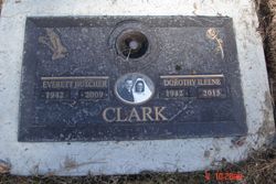
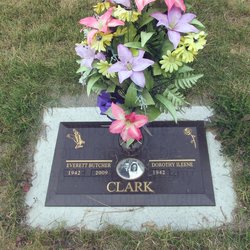
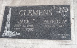
Dorothy Ileene Clemens Clark
| Birth | : | 21 Jun 1942 Pincher Creek, Claresholm Census Division, Alberta, Canada |
| Death | : | 17 May 2015 |
| Burial | : | Marysville Cemetery, Marysville, East Kootenay Regional District, Canada |
| Coordinate | : | 49.6386900, -115.9513300 |
| Description | : | Dorothy was born on June 21, 1942 to Wilf and Eileen Clemens of Pincher Creek, Alberta and was the second oldest of eight children. She was married to her loving husband Butch for 46 years before he was tragically taken from us in 2009. Dorothy’s greatest love was her family and especially her grandchildren. She was a mother, grandmother, sister, aunt and friend to many and touched so many lives in such a positive and loving way. Many people will remember her from over the 20 years that she and Butch owned and operated the Petro Canada in Marysville... Read More |
frequently asked questions (FAQ):
-
Where is Dorothy Ileene Clemens Clark's memorial?
Dorothy Ileene Clemens Clark's memorial is located at: Marysville Cemetery, Marysville, East Kootenay Regional District, Canada.
-
When did Dorothy Ileene Clemens Clark death?
Dorothy Ileene Clemens Clark death on 17 May 2015 in
-
Where are the coordinates of the Dorothy Ileene Clemens Clark's memorial?
Latitude: 49.6386900
Longitude: -115.9513300
Family Members:
Parent

Spouse
Siblings
Flowers:


Nearby Cemetories:
1. Marysville Cemetery
Marysville, East Kootenay Regional District, Canada
Coordinate: 49.6386900, -115.9513300
2. Kimberley Cemetery
Kimberley, East Kootenay Regional District, Canada
Coordinate: 49.6766700, -115.9746000
3. Aqam Cemetery
Cranbrook, East Kootenay Regional District, Canada
Coordinate: 49.5833840, -115.7574800
4. Cranbrook New General Cemetery
Cranbrook, East Kootenay Regional District, Canada
Coordinate: 49.5118890, -115.7837250
5. Cranbrook Old General Cemetery
Cranbrook, East Kootenay Regional District, Canada
Coordinate: 49.5116630, -115.7826420
6. Westlawn Cemetery
Cranbrook, East Kootenay Regional District, Canada
Coordinate: 49.5112220, -115.7821910
7. Cranbrook Catholic Cemetery
Cranbrook, East Kootenay Regional District, Canada
Coordinate: 49.5114080, -115.7813930
8. Fort Steele Cemetery
Fort Steele, East Kootenay Regional District, Canada
Coordinate: 49.6260109, -115.6225662
9. Moyie Cemetery
Moyie, East Kootenay Regional District, Canada
Coordinate: 49.2743920, -115.8350350
10. Sand Creek Cemetery
Jaffray, East Kootenay Regional District, Canada
Coordinate: 49.3362250, -115.2909390
11. Canal Flats Cemetery
Canal Flats, East Kootenay Regional District, Canada
Coordinate: 50.1617820, -115.8049420
12. Gray Creek Cemetery
Gray Creek, Central Kootenay Regional District, Canada
Coordinate: 49.6259540, -116.7854990
13. Yahk Cemetery
Yahk, Central Kootenay Regional District, Canada
Coordinate: 49.0885510, -116.0776230
14. Boswell Cemetery
Boswell, Central Kootenay Regional District, Canada
Coordinate: 49.4552000, -116.7615000
15. Crawford Bay Cemetery
Crawford Bay, Central Kootenay Regional District, Canada
Coordinate: 49.6945390, -116.8138077
16. Goat River Cemetery
Creston, Central Kootenay Regional District, Canada
Coordinate: 49.1411200, -116.3992060
17. Fernie Cemetery
Fernie, East Kootenay Regional District, Canada
Coordinate: 49.5002240, -115.0579050
18. East Fernie Cemetery
Fernie, East Kootenay Regional District, Canada
Coordinate: 49.5018590, -115.0566640
19. Saint Margaret's Cemetery
Fernie, East Kootenay Regional District, Canada
Coordinate: 49.4989900, -115.0550900
20. Ainsworth Cemetery
Ainsworth Hot Springs, Central Kootenay Regional District, Canada
Coordinate: 49.7333330, -116.9094190
21. Baynes Lake Cemetery
Baynes Lake, East Kootenay Regional District, Canada
Coordinate: 49.2369900, -115.2106000
22. Elko Cemetery
Elko, East Kootenay Regional District, Canada
Coordinate: 49.2978200, -115.1353500
23. Forest Lawn Cemetery
Creston, Central Kootenay Regional District, Canada
Coordinate: 49.0991400, -116.4626400
24. Hosmer Cemetery
Hosmer, East Kootenay Regional District, Canada
Coordinate: 49.5863580, -114.9565980