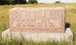
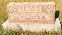
Dorothy Krythe De Boer
| Birth | : | 18 Jun 1917 Fort Macleod, Claresholm Census Division, Alberta, Canada |
| Death | : | 28 Feb 2006 |
| Burial | : | Granum Christian Reformed Church Cemetery, Granum, Claresholm Census Division, Canada |
| Coordinate | : | 49.8622100, -113.3436600 |
| Description | : | Dorothy De Boer (nee Krythe) passed away to be with her Lord on Tuesday, Feb. 28, 2006. Romans 10:9: ³That if you confess with your mouth, ŒJesus is Lord¹ and believe in your heart that God raised him from the dead, you will be saved.² Dorothy was born on June 18, 1917 on a farm north of Fort Macleod, across the road from the Hollandale school, and she completed her schooling there. For some years she helped on the farm until she married Peter De Boer. Together they farmed near the old home place and raised four children.... Read More |
frequently asked questions (FAQ):
-
Where is Dorothy Krythe De Boer's memorial?
Dorothy Krythe De Boer's memorial is located at: Granum Christian Reformed Church Cemetery, Granum, Claresholm Census Division, Canada.
-
When did Dorothy Krythe De Boer death?
Dorothy Krythe De Boer death on 28 Feb 2006 in
-
Where are the coordinates of the Dorothy Krythe De Boer's memorial?
Latitude: 49.8622100
Longitude: -113.3436600
Family Members:
Parent
Spouse
Children
Nearby Cemetories:
1. Granum Christian Reformed Church Cemetery
Granum, Claresholm Census Division, Canada
Coordinate: 49.8622100, -113.3436600
2. Jumbo Valley Hutterite Cemetery
Granum, Claresholm Census Division, Canada
Coordinate: 49.8452911, -113.3425358
3. White Lake Cemetery
Nobleford, Lethbridge Census Division, Canada
Coordinate: 49.9018700, -113.2107750
4. White Lake Hutterite Cemetery
Nobleford, Lethbridge Census Division, Canada
Coordinate: 49.9154153, -113.2084160
5. Granum Cemetery
Granum, Claresholm Census Division, Canada
Coordinate: 49.8812800, -113.5251600
6. Orton Cemetery
Orton, Claresholm Census Division, Canada
Coordinate: 49.7484600, -113.2540900
7. Union Cemetery
Fort Macleod, Claresholm Census Division, Canada
Coordinate: 49.7306500, -113.3882000
8. Holy Cross Cemetery
Fort Macleod, Claresholm Census Division, Canada
Coordinate: 49.7283000, -113.3882400
9. Nobleford Monarch Cemetery
Nobleford, Lethbridge Census Division, Canada
Coordinate: 49.8456500, -113.0942100
10. Granum Hutterite Cemetery
Granum, Claresholm Census Division, Canada
Coordinate: 49.8513248, -113.6038772
11. Monarch Cemetery
Monarch, Lethbridge Census Division, Canada
Coordinate: 49.8020980, -113.0953220
12. Five Mile Cemetery
Claresholm, Claresholm Census Division, Canada
Coordinate: 50.0188250, -113.4705730
13. Elinor Cemetery
Barons, Lethbridge Census Division, Canada
Coordinate: 50.0271520, -113.2340240
14. Barons Cemetery
Barons, Lethbridge Census Division, Canada
Coordinate: 49.9756500, -113.0993100
15. Saint Peter's Lutheran Cemetery
Claresholm, Claresholm Census Division, Canada
Coordinate: 50.0487620, -113.4822460
16. Claresholm Cemetery
Claresholm, Claresholm Census Division, Canada
Coordinate: 50.0114784, -113.5946503
17. Keho Lake Hutterite Cemetery
Barons, Lethbridge Census Division, Canada
Coordinate: 49.9891594, -113.0160634
18. Carmangay Cemetery
Carmangay, Strathmore Census Division, Canada
Coordinate: 50.1214300, -113.1434300
19. Albion Ridge Cemetery
Barons, Lethbridge Census Division, Canada
Coordinate: 49.9598350, -112.9169650
20. Alston Cemetery
Vulcan, Strathmore Census Division, Canada
Coordinate: 50.1652820, -113.2450470
21. Carmangay Hutterite Cemetery
Carmangay, Strathmore Census Division, Canada
Coordinate: 50.0841743, -113.0067984
22. Archmount Cemetery
Lethbridge, Lethbridge Census Division, Canada
Coordinate: 49.7057900, -112.9017500
23. Isol Russell Grave
Champion, Strathmore Census Division, Canada
Coordinate: 50.1792300, -113.2102100
24. Bratton Family Cemetery
Spring Point, Claresholm Census Division, Canada
Coordinate: 49.7150200, -113.8017500

