
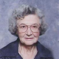
Dorothy L McNary Gilliland
| Birth | : | 14 Jan 1911 Mont Ida, Anderson County, Kansas, USA |
| Death | : | 22 May 2012 Overbrook, Osage County, Kansas, USA |
| Burial | : | Dean Cemetery, Pomona, Franklin County, USA |
| Coordinate | : | 38.7038994, -95.4781036 |
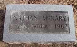
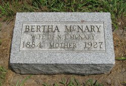
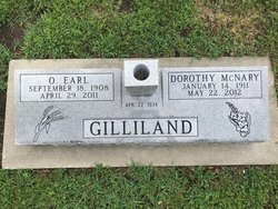
| Description | : | . Gilliland passed away May 22, 2012, in Overbrook, Kansas. She was born January 14, 1911 at Mount Ida, Kansas, the daughter of Nathan T. and Bertha A. McNary. She attended schools in the Burlington, Kansas area and graduated from Pomona High School in1930. She taught four years in rural schools around Pomona. She married Earl Gilliland April 22, 1934 and farmed with him in the Pomona area. She was active in the Beacon Light EHU and later in the county at large group. She was a 4-H leader for the Appanoose 4-H for several years. In 1970 she was... Read More |
frequently asked questions (FAQ):
-
Where is Dorothy L McNary Gilliland's memorial?
Dorothy L McNary Gilliland's memorial is located at: Dean Cemetery, Pomona, Franklin County, USA.
-
When did Dorothy L McNary Gilliland death?
Dorothy L McNary Gilliland death on 22 May 2012 in Overbrook, Osage County, Kansas, USA
-
Where are the coordinates of the Dorothy L McNary Gilliland's memorial?
Latitude: 38.7038994
Longitude: -95.4781036
Family Members:
Parent
Spouse
Siblings
Flowers:


Nearby Cemetories:
1. Dean Cemetery
Pomona, Franklin County, USA
Coordinate: 38.7038994, -95.4781036
2. Appanoose Cemetery
Globe, Douglas County, USA
Coordinate: 38.7392006, -95.4642029
3. Pleasant Hill Cemetery
Centropolis, Franklin County, USA
Coordinate: 38.7243996, -95.4021988
4. Pleasant Ridge Cemetery
Osage County, USA
Coordinate: 38.6492004, -95.5271988
5. Kaub Cemetery
Centropolis, Franklin County, USA
Coordinate: 38.7172012, -95.3899994
6. Valley Brook Cemetery
Michigan Valley, Osage County, USA
Coordinate: 38.7242279, -95.5646362
7. Dodder Cemetery
Baldwin City, Douglas County, USA
Coordinate: 38.7827988, -95.4452972
8. Overbrook Cemetery
Overbrook, Osage County, USA
Coordinate: 38.7751083, -95.5487442
9. Union Cemetery
Globe, Douglas County, USA
Coordinate: 38.7407800, -95.3713000
10. Woodlawn Cemetery
Pomona, Franklin County, USA
Coordinate: 38.6100006, -95.4681015
11. Parkinson Cemetery
Franklin County, USA
Coordinate: 38.6479500, -95.3804800
12. Centropolis Cemetery
Centropolis, Franklin County, USA
Coordinate: 38.7242737, -95.3525009
13. Eastview Cemetery
Quenemo, Osage County, USA
Coordinate: 38.6081009, -95.5235977
14. Mount Zion Cemetery
Vassar, Osage County, USA
Coordinate: 38.6796989, -95.6181030
15. Minneola Cemetery
Centropolis, Franklin County, USA
Coordinate: 38.7036200, -95.3345900
16. Lamont Hill Cemetery
Vassar, Osage County, USA
Coordinate: 38.6392400, -95.6004600
17. Oak Hill Cemetery
Quenemo, Osage County, USA
Coordinate: 38.5918999, -95.5333023
18. Foster Cemetery
Ottawa, Franklin County, USA
Coordinate: 38.6651390, -95.3324460
19. Salt Creek Cemetery
Osage County, USA
Coordinate: 38.6164100, -95.5875300
20. Bethel Cemetery
Worden, Douglas County, USA
Coordinate: 38.7675018, -95.3439026
21. Nightingale Farm Cemetery
Pomona, Franklin County, USA
Coordinate: 38.5815300, -95.4409300
22. Vassar Cemetery
Osage County, USA
Coordinate: 38.6408005, -95.6192017
23. Greenwood Cemetery
Franklin County, USA
Coordinate: 38.5781700, -95.4145900
24. Washington Creek Cemetery
Lone Star, Douglas County, USA
Coordinate: 38.8273800, -95.3997900