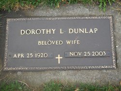
Dorothy Louise “Dote” Hardenbrook Dunlap
| Birth | : | 25 Apr 1920 Beaver City, Furnas County, Nebraska, USA |
| Death | : | 25 Nov 2003 Kelso, Cowlitz County, Washington, USA |
| Burial | : | Iberia Cemetery, Iberia, Morrow County, USA |
| Coordinate | : | 40.6683006, -82.8343964 |
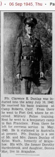
| Description | : | Dorothy L. Dunlap, 83, passed away November 23, 2003 at home, after a long illness. Dorothy was born April 25, 1920 in the family's home near Beaver City, Furnas County, Nebraska. Dorothy graduated from Arapahoe Sr. High in Nebraska in 1938. She was engaged to her future husband Clarence E. Dunlap on August 6, 1936. They married on June 16, 1941 in Trenton, Nebraska, and stayed devoted to each other until his death on July 29, 1998. Dorothy was employed under the W.P.A. program created by F.D.R. during the depression. Part of the W.P.A. program was responsible for the preservation... Read More |
frequently asked questions (FAQ):
-
Where is Dorothy Louise “Dote” Hardenbrook Dunlap's memorial?
Dorothy Louise “Dote” Hardenbrook Dunlap's memorial is located at: Iberia Cemetery, Iberia, Morrow County, USA.
-
When did Dorothy Louise “Dote” Hardenbrook Dunlap death?
Dorothy Louise “Dote” Hardenbrook Dunlap death on 25 Nov 2003 in Kelso, Cowlitz County, Washington, USA
-
Where are the coordinates of the Dorothy Louise “Dote” Hardenbrook Dunlap's memorial?
Latitude: 40.6683006
Longitude: -82.8343964
Family Members:
Spouse
Children
Flowers:
Nearby Cemetories:
1. Iberia Cemetery
Iberia, Morrow County, USA
Coordinate: 40.6683006, -82.8343964
2. Parrott Family Cemetery
Morrow County, USA
Coordinate: 40.6468198, -82.8215029
3. Tuttle Cemetery
Morrow County, USA
Coordinate: 40.6925011, -82.8210983
4. Goodrich Cemetery
Washington Township, Morrow County, USA
Coordinate: 40.6981820, -82.8175930
5. Forbes Cemetery
Morrow County, USA
Coordinate: 40.7042007, -82.8268967
6. Autin Cemetery
Washington Township, Morrow County, USA
Coordinate: 40.7122002, -82.8264008
7. Dye Cemetery
Morrow County, USA
Coordinate: 40.6910950, -82.7775550
8. West Point Cemetery
West Point, Morrow County, USA
Coordinate: 40.6366997, -82.7844009
9. Ebenezer Methodist Episcopal Cemetery
West Point, Morrow County, USA
Coordinate: 40.6702430, -82.7660500
10. Rush Cemetery
Martel, Marion County, USA
Coordinate: 40.6904660, -82.8980260
11. Armstrong Cemetery
Washington Township, Morrow County, USA
Coordinate: 40.6144000, -82.8228960
12. Park Cemetery
Galion, Crawford County, USA
Coordinate: 40.7266410, -82.8213790
13. Garverick Cemetery
West Point, Morrow County, USA
Coordinate: 40.6394005, -82.7658005
14. Zoar Cemetery
Crawford County, USA
Coordinate: 40.7299995, -82.8488998
15. Cooley Cemetery
Canaan Township, Morrow County, USA
Coordinate: 40.6445040, -82.9177850
16. German Sixteen Methodist Church Cemetery
Martel, Marion County, USA
Coordinate: 40.6893270, -82.9194560
17. Sixteen Cemetery
Crawford County, USA
Coordinate: 40.7047005, -82.9107971
18. Moffit Cemetery
Morrow County, USA
Coordinate: 40.6027985, -82.7983017
19. Pletcher Cemetery
Galion, Crawford County, USA
Coordinate: 40.7395348, -82.8392529
20. Bortner Cemetery
Morrow County, USA
Coordinate: 40.6531142, -82.7412886
21. Peace Lutheran Church Columbarium
Galion, Crawford County, USA
Coordinate: 40.7331469, -82.7897680
22. Union Green Cemetery
Galion, Crawford County, USA
Coordinate: 40.7359860, -82.7919280
23. North Canaan Cemetery
Denmark, Morrow County, USA
Coordinate: 40.6231003, -82.9171982
24. Hershner Cemetery
Mount Gilead, Morrow County, USA
Coordinate: 40.5893030, -82.8336760


