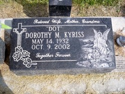
Dorothy Marie “Dot” Encinger Kyriss
| Birth | : | 14 May 1932 Grand Island, Hall County, Nebraska, USA |
| Death | : | 9 Oct 2002 Columbus, Platte County, Nebraska, USA |
| Burial | : | Lakeview Cemetery, Sugar City, Crowley County, USA |
| Coordinate | : | 38.2332993, -103.6725006 |
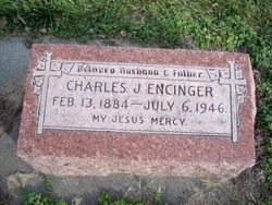
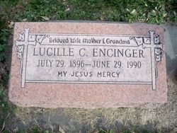
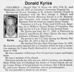
| Description | : | Daughter of Charles & Lucille (Swolek) Encinger. She moved to Columbus and attended St. Anthony Grade School & graduated from Kramer High School in 1950. On June 12, 1954 Dorothy was united in marriage to Donald E. Kyriss. She worked as Deputy County Clerk under Carl Hoge until being appointed Platte County Election Commissioner until retiring in 1996. Dorothy was a member of St. Anthony Catholic Church, St. Theresa Sodality, served as EME and Church Lector. She was a member of the American Business Womens Association , Eagles Auxiliary , Womens Division, and Alumni Board at Columbus High School. Dorothy enjoyed... Read More |
frequently asked questions (FAQ):
-
Where is Dorothy Marie “Dot” Encinger Kyriss's memorial?
Dorothy Marie “Dot” Encinger Kyriss's memorial is located at: Lakeview Cemetery, Sugar City, Crowley County, USA.
-
When did Dorothy Marie “Dot” Encinger Kyriss death?
Dorothy Marie “Dot” Encinger Kyriss death on 9 Oct 2002 in Columbus, Platte County, Nebraska, USA
-
Where are the coordinates of the Dorothy Marie “Dot” Encinger Kyriss's memorial?
Latitude: 38.2332993
Longitude: -103.6725006
Family Members:
Parent
Spouse
Siblings
Flowers:
Nearby Cemetories:
1. Lakeview Cemetery
Sugar City, Crowley County, USA
Coordinate: 38.2332993, -103.6725006
2. Valley View Cemetery
Ordway, Crowley County, USA
Coordinate: 38.2546997, -103.7489014
3. Holbrook Cemetery
Otero County, USA
Coordinate: 38.0842018, -103.5432968
4. Hillcrest Cemetery
Rocky Ford, Otero County, USA
Coordinate: 38.0388985, -103.7071991
5. Valley View Cemetery
Rocky Ford, Otero County, USA
Coordinate: 38.0388985, -103.7093964
6. East Holbrook Mennonite Cemetery
Cheraw, Otero County, USA
Coordinate: 38.1101837, -103.4729767
7. Manzanola Mountainview Cemetery
Manzanola, Otero County, USA
Coordinate: 38.0900002, -103.8764038
8. Olney Springs Cemetery
Olney Springs, Crowley County, USA
Coordinate: 38.1472282, -103.9310684
9. Barnard Burial Site
Elder, Otero County, USA
Coordinate: 38.1235554, -103.9665095
10. Sand Arroyo Cemetery
Crowley County, USA
Coordinate: 38.4658500, -103.5229300
11. Fairview Cemetery
La Junta, Otero County, USA
Coordinate: 37.9873000, -103.5607000
12. Arlington Cemetery
Arlington, Kiowa County, USA
Coordinate: 38.3232994, -103.3597031
13. Saint Paul’s Lutheran Cemetery
Otero County, USA
Coordinate: 38.0342000, -103.4542000
14. Calvary Cemetery
La Junta, Otero County, USA
Coordinate: 37.9832000, -103.5622000
15. Bents Old Fort Cemetery
La Junta, Otero County, USA
Coordinate: 38.0416000, -103.4297000
16. Saint Andrews Episcopal Church Columbarium
La Junta, Otero County, USA
Coordinate: 37.9809000, -103.5455000
17. Ormega Cemetery
La Junta, Otero County, USA
Coordinate: 37.9684000, -103.5770000
18. Fowler Cemetery
Fowler, Otero County, USA
Coordinate: 38.1301000, -104.0076000
19. Nepesta Cemetery
Nepesta, Pueblo County, USA
Coordinate: 38.1672000, -104.1436000
20. Lucero Family Cemetery
Nepesta, Pueblo County, USA
Coordinate: 38.1677340, -104.1480540
21. Las Animas Cemetery
Las Animas, Bent County, USA
Coordinate: 38.0424995, -103.2174988
22. Boggsville National Historic Site Grounds
Boggsville, Bent County, USA
Coordinate: 38.0425130, -103.2102730
23. Spring Hill Cemetery
Lincoln County, USA
Coordinate: 38.6458015, -103.7427979
24. Grandma Forgey Grave
Karval, Lincoln County, USA
Coordinate: 38.6511028, -103.6674361


