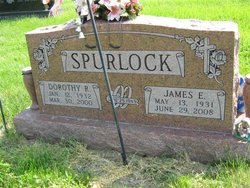
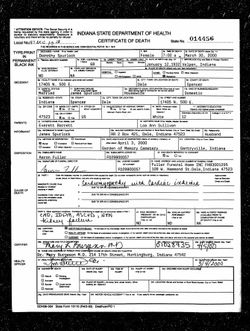
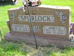
Dorothy Rae Barrett Spurlock
| Birth | : | 12 Jan 1932 Velpen, Pike County, Indiana, USA |
| Death | : | 30 Mar 2000 Dale, Spencer County, Indiana, USA |
| Burial | : | Saint Matthew's Anglican Cemetery, New Norfolk, Derwent Valley Council, Australia |
| Coordinate | : | -42.7806289, 147.0664250 |
| Plot | : | North of the flag pole. |
| Inscription | : | "Married June 25, 1949 -- Our children, LaDonna, Lynn, Connie, Gary" |
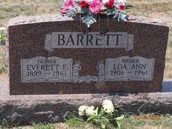
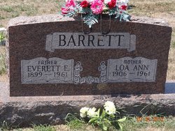
| Description | : | Daughter of Everett Edward Barrett and Loa Ann Sullivan Barrett. Married to James E Spurlock. ********************************** 1940 United States Federal Census Name: Dorothy R Barrett Age: 8 Estimated birth year: abt 1932 Gender: Female Race: White Birthplace: Indiana Marital status: Single Relation to Head of House: Daughter Home in 1940: Marion, Pike, Indiana Street: Different Short Street In Velpen(As Mimbised On Map Inferred Residence in 1935: Marion, Pike, Indiana Residence in 1935: Same Place Sheet Number: 6A Attended School or College: Yes Highest Grade Completed: Elementary school, 2nd grade Household Members: Name Age Everett Barrett 40 Lou Barrett... Read More |
frequently asked questions (FAQ):
-
Where is Dorothy Rae Barrett Spurlock's memorial?
Dorothy Rae Barrett Spurlock's memorial is located at: Saint Matthew's Anglican Cemetery, New Norfolk, Derwent Valley Council, Australia.
-
When did Dorothy Rae Barrett Spurlock death?
Dorothy Rae Barrett Spurlock death on 30 Mar 2000 in Dale, Spencer County, Indiana, USA
-
Where are the coordinates of the Dorothy Rae Barrett Spurlock's memorial?
Latitude: -42.7806289
Longitude: 147.0664250
Family Members:
Parent
Spouse
Siblings
Children
Flowers:
Nearby Cemetories:
1. Saint Matthew's Anglican Cemetery
New Norfolk, Derwent Valley Council, Australia
Coordinate: -42.7806289, 147.0664250
2. St. Matthew’s Anglican Columbarium Wall
New Norfolk, Derwent Valley Council, Australia
Coordinate: -42.7792220, 147.0673080
3. New Norfolk Old Cemetery
New Norfolk, Derwent Valley Council, Australia
Coordinate: -42.7719330, 147.0579860
4. Lawitta Church Cemetery
Magra, Derwent Valley Council, Australia
Coordinate: -42.7661690, 147.0331060
5. Malbina General Cemetery
Malbina, Derwent Valley Council, Australia
Coordinate: -42.7866610, 147.1184830
6. Plenty Anglican Church Cemetery
Plenty, Derwent Valley Council, Australia
Coordinate: -42.7382900, 146.9605860
7. Jackman Graveyard
Collinsvale, Glenorchy City, Australia
Coordinate: -42.8406720, 147.1639470
8. Collinsvale Uniting Church Cemetery
Collinsvale, Glenorchy City, Australia
Coordinate: -42.8410560, 147.1991720
9. St. Mary's Anglican Cemetery
Bridgewater, Brighton Council, Australia
Coordinate: -42.7374010, 147.2282310
10. Hestercombe Uniting Church Cemetery
Austins Ferry, Glenorchy City, Australia
Coordinate: -42.7695190, 147.2448030
11. St. Augustine's Anglican Cemetery
Broadmarsh, Southern Midlands Council, Australia
Coordinate: -42.6380880, 147.1158740
12. Red Hills Cemetery
Bushy Park, Derwent Valley Council, Australia
Coordinate: -42.7091350, 146.8893740
13. St. Mary's Church of England Cemetery
Gretna, Central Highlands Council, Australia
Coordinate: -42.6669200, 146.9333810
14. Broadmarsh Congregational Cemetery
Broadmarsh, Southern Midlands Council, Australia
Coordinate: -42.6344620, 147.1129760
15. St. Paul's Anglican Church Cemetery
Glenorchy, Glenorchy City, Australia
Coordinate: -42.8275410, 147.2665830
16. Glenorchy Chapel Burial Ground
Glenorchy, Glenorchy City, Australia
Coordinate: -42.8317820, 147.2704320
17. St George's Church of England Cemetery
Gagebrook, Brighton Council, Australia
Coordinate: -42.7499706, 147.2793948
18. St Matthews Church Cemetery
Glenorchy, Glenorchy City, Australia
Coordinate: -42.8329730, 147.2743670
19. Pontville Saint Matthews Roman Catholic Cemetery
Brighton, Brighton Council, Australia
Coordinate: -42.6900390, 147.2629800
20. St. Mark's Anglican Cemetery
Pontville, Southern Midlands Council, Australia
Coordinate: -42.6807150, 147.2663860
21. St John’s Anglican Church Cemetery
New Town, Hobart City, Australia
Coordinate: -42.8550230, 147.2969180
22. New Town Congregational Cemetery
New Town, Hobart City, Australia
Coordinate: -42.8545680, 147.3026230
23. East Risdon Cemetery
Risdon, Clarence City, Australia
Coordinate: -42.8211910, 147.3184970
24. St. Michael's Anglican Cemetery
Bagdad, Southern Midlands Council, Australia
Coordinate: -42.6263790, 147.2226500

