

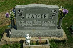
Dorothy Verlee Barr Van Amerongen
| Birth | : | 26 Dec 1935 Henry County, Iowa, USA |
| Death | : | 23 May 2009 Mount Pleasant, Henry County, Iowa, USA |
| Burial | : | Lambirth Cemetery, Henry County, USA |
| Coordinate | : | 40.9230995, -91.7149963 |
| Description | : | Verlee Carver Van Amerongen, 73, of Mt. Pleasant, IA, died Saturday, May 23, 2009, at the Park Place Long Term Care Unit in Mt. Pleasant. Born December 27, 1935, in Henry County, IA, D. Verlee was the daughter of Earl Paxton and Opal Verlee Nihart Barr. She was a Mt. Pleasant High School graduate. On June 19, 1953, she married Donald Carver, who preceded her in death on November 22, 1985. Verlee married Clarence Cornelius Van Amerongen on April 22, 1989, at Harmony Bible Church. He survives. Following high school, Verlee worked at Sheaffer Pen in Fort Madison, and then General Electric... Read More |
frequently asked questions (FAQ):
-
Where is Dorothy Verlee Barr Van Amerongen's memorial?
Dorothy Verlee Barr Van Amerongen's memorial is located at: Lambirth Cemetery, Henry County, USA.
-
When did Dorothy Verlee Barr Van Amerongen death?
Dorothy Verlee Barr Van Amerongen death on 23 May 2009 in Mount Pleasant, Henry County, Iowa, USA
-
Where are the coordinates of the Dorothy Verlee Barr Van Amerongen's memorial?
Latitude: 40.9230995
Longitude: -91.7149963
Family Members:
Spouse

Flowers:


Nearby Cemetories:
1. Lambirth Cemetery
Henry County, USA
Coordinate: 40.9230995, -91.7149963
2. Crane Cemetery
Glasgow, Jefferson County, USA
Coordinate: 40.9250189, -91.7279368
3. Gilmer Cemetery
Jefferson County, USA
Coordinate: 40.9486008, -91.7564011
4. Hickory Grove Cemetery
Van Buren County, USA
Coordinate: 40.8869019, -91.7469025
5. Pleasant Point Cemetery
Henry County, USA
Coordinate: 40.9448000, -91.6545000
6. Upland Cemetery
Lockridge, Jefferson County, USA
Coordinate: 40.9700012, -91.7461014
7. Smith Family Burial Site
Mount Pleasant, Henry County, USA
Coordinate: 40.9755300, -91.6987500
8. Glasgow Cemetery
Glasgow, Jefferson County, USA
Coordinate: 40.9375000, -91.7838974
9. Grant Cemetery
Rome, Henry County, USA
Coordinate: 40.9880981, -91.6992035
10. Cedar Creek Cemetery
Salem, Henry County, USA
Coordinate: 40.8983002, -91.6307983
11. Hopkirk Family Cemetery
Lockridge, Jefferson County, USA
Coordinate: 40.9928820, -91.7396530
12. Oakland Mills Cemetery
Oakland Mills, Henry County, USA
Coordinate: 40.9340000, -91.6183000
13. Sample Cemetery
Henry County, USA
Coordinate: 40.9812000, -91.6528000
14. Jones Family Cemetery
Jefferson County, USA
Coordinate: 40.9302000, -91.8164000
15. Spencer Cemetery
Stockport, Van Buren County, USA
Coordinate: 40.8792000, -91.8007965
16. Lockridge Cemetery
Lockridge, Jefferson County, USA
Coordinate: 40.9952000, -91.7558500
17. Mount Zion Cemetery
Jefferson County, USA
Coordinate: 40.9617004, -91.8082962
18. Hopkirk Cemetery
Jefferson County, USA
Coordinate: 41.0029000, -91.7566000
19. Fiedler Cemetery
Glasgow, Jefferson County, USA
Coordinate: 40.9321000, -91.8280000
20. Short Family Burials
Henry County, USA
Coordinate: 40.9352500, -91.6019800
21. Bonnifield Cemetery
Lockridge, Jefferson County, USA
Coordinate: 40.9874992, -91.7966995
22. Faulkner Cemetery
Oakland Mills, Henry County, USA
Coordinate: 40.9207000, -91.5966000
23. Hillsboro Cemetery
Hillsboro, Henry County, USA
Coordinate: 40.8310400, -91.7145000
24. New Swedish Methodist Church Cemetery
Jefferson County, USA
Coordinate: 41.0037384, -91.7763519