
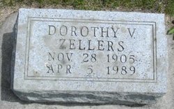
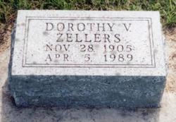

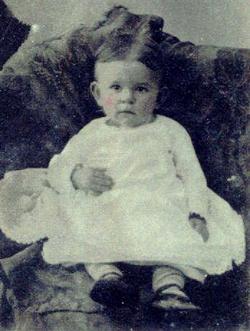
Dorothy Verna Zellers Short
| Birth | : | 28 Nov 1905 Redfield, Dallas County, Iowa, USA |
| Death | : | 5 Apr 1989 Fort Dodge, Webster County, Iowa, USA |
| Burial | : | St. Paul's Wesleyan Methodist Churchyard, Swinton, Metropolitan Borough of Salford, England |
| Coordinate | : | 53.5133900, -2.3397500 |
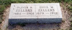
| Description | : | Dorothy V. (Zellers)Short was the D/O Oliver Benton Zellers & Effie (Myers) Zellers, married in 1926 to Carlton Short, who passed away in 1961, then Dorothy took back her maiden name.∼REDFIELD -- A funeral for Dorothy Zellers, 83, of Fort Dodge was held April 8, 1989 at the United Methodist Church here. Miss Zellers died of a stroke on April 5 at Tompkin Memorial Health Center at Fort Dodge. Burial was in the Panther Creek Brethren Cemetery near Adel. She was born in Dallas County and lived in Redfield from 1973 to 1985 when she moved... Read More |
frequently asked questions (FAQ):
-
Where is Dorothy Verna Zellers Short's memorial?
Dorothy Verna Zellers Short's memorial is located at: St. Paul's Wesleyan Methodist Churchyard, Swinton, Metropolitan Borough of Salford, England.
-
When did Dorothy Verna Zellers Short death?
Dorothy Verna Zellers Short death on 5 Apr 1989 in Fort Dodge, Webster County, Iowa, USA
-
Where are the coordinates of the Dorothy Verna Zellers Short's memorial?
Latitude: 53.5133900
Longitude: -2.3397500
Family Members:
Parent
Siblings
Children
Flowers:


Nearby Cemetories:
1. St. Paul's Wesleyan Methodist Churchyard
Swinton, Metropolitan Borough of Salford, England
Coordinate: 53.5133900, -2.3397500
2. St. Peter's Churchyard
Swinton, Metropolitan Borough of Salford, England
Coordinate: 53.5119130, -2.3413860
3. Swinton Cemetery
Swinton, Metropolitan Borough of Salford, England
Coordinate: 53.5183372, -2.3457739
4. Saint Augustine's Churchyard
Pendlebury, Metropolitan Borough of Salford, England
Coordinate: 53.5107070, -2.3223960
5. St Anne Churchyard
Clifton, Metropolitan Borough of Salford, England
Coordinate: 53.5277070, -2.3391650
6. St Mary's Catholic Cemetery
Wardley, Metropolitan Borough of Salford, England
Coordinate: 53.5163700, -2.3645900
7. St John The Evangelist Churchyard
Pendlebury, Metropolitan Borough of Salford, England
Coordinate: 53.5036200, -2.3088500
8. Agecroft Jewish Cemetery
Pendlebury, Metropolitan Borough of Salford, England
Coordinate: 53.5110302, -2.2955830
9. Agecroft Cemetery and Crematorium
Salford, Metropolitan Borough of Salford, England
Coordinate: 53.5100250, -2.2940500
10. St Mark Churchyard
Worsley, Metropolitan Borough of Salford, England
Coordinate: 53.5024361, -2.3833430
11. St Mary the Virgin Churchyard
Eccles, Metropolitan Borough of Salford, England
Coordinate: 53.4843810, -2.3346810
12. Rainsough Jewish Cemetery
Prestwich, Metropolitan Borough of Bury, England
Coordinate: 53.5185530, -2.2906950
13. St Stephen churchyard
Kearsley, Metropolitan Borough of Bolton, England
Coordinate: 53.5381650, -2.3717160
14. St Saviour churchyard
Ringley, Metropolitan Borough of Bolton, England
Coordinate: 53.5439030, -2.3576830
15. St Paul Churchyard
Walkden, Metropolitan Borough of Salford, England
Coordinate: 53.5231133, -2.3947620
16. St. Mary the Virgin Churchyard
Prestwich, Metropolitan Borough of Bury, England
Coordinate: 53.5294033, -2.2864891
17. Great Synagogue Cemetery
Prestwich, Metropolitan Borough of Bury, England
Coordinate: 53.5315510, -2.2845730
18. Barton Wesleyan Methodist Chapelyard
Eccles, Metropolitan Borough of Salford, England
Coordinate: 53.4763680, -2.3559280
19. St. Thomas' Churchyard
Salford, Metropolitan Borough of Salford, England
Coordinate: 53.4921430, -2.2856130
20. Barton Upon Irwell Roman Catholic Graveyard
Metropolitan Borough of Salford, England
Coordinate: 53.4753010, -2.3554530
21. St Paul's Churchyard
Salford, Metropolitan Borough of Salford, England
Coordinate: 53.5148800, -2.2725500
22. Weaste Cemetery
Weaste, Metropolitan Borough of Salford, England
Coordinate: 53.4795227, -2.3017540
23. Stand United Reformed Church Burial Ground
Radcliffe, Metropolitan Borough of Bury, England
Coordinate: 53.5512300, -2.3140600
24. St. Catherine's Churchyard
Barton-upon-Irwell, Metropolitan Borough of Salford, England
Coordinate: 53.4733160, -2.3542070