
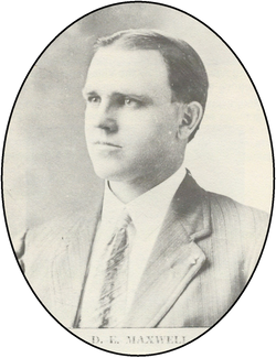
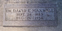
Dr David Edward Maxwell
| Birth | : | 26 Sep 1883 Cedar Rapids, Boone County, Nebraska, USA |
| Death | : | 26 Dec 1954 |
| Burial | : | Bantam Burying Ground, Bantam, Litchfield County, USA |
| Coordinate | : | 41.7250900, -73.2322083 |
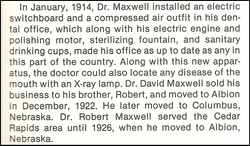
| Description | : | Web site @ http://www.usgennet.org/usa/ne/county/platte/whoplabios.html MAXWELL, DAVID EDWARD: Dentist; b Cedar Rapids, Neb Sept 26, 1883; s of John Maxwell-Anna Dobson; ed Cedar Rapids HS; U of N, DDS 1908; m Lucy E Farley June 26, 1912 Cedar Rapids, d Helen Lucille; 1908-17 prac dentistry at Cedar Rapids; 1918-26 prac at Albion; 1926- prac, Columbus; Platte Co Dental Soc; Neb State Dental Assn; ADA; C of C; Kiwanis; Wayside Country Club, past pres; AF&AM, 32°; Scot Rite; Tangier Shrine; Meth Ch; Rep; hobby, golf; res Columbus. |
frequently asked questions (FAQ):
-
Where is Dr David Edward Maxwell's memorial?
Dr David Edward Maxwell's memorial is located at: Bantam Burying Ground, Bantam, Litchfield County, USA.
-
When did Dr David Edward Maxwell death?
Dr David Edward Maxwell death on 26 Dec 1954 in
-
Where are the coordinates of the Dr David Edward Maxwell's memorial?
Latitude: 41.7250900
Longitude: -73.2322083
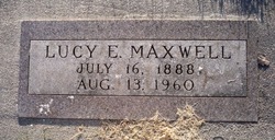
Family Members:
Parent

Spouse
Siblings
Flowers:


Nearby Cemetories:
1. Bantam Burying Ground
Bantam, Litchfield County, USA
Coordinate: 41.7250900, -73.2322083
2. Our Lady of Grace Cemetery
Bantam, Litchfield County, USA
Coordinate: 41.7242250, -73.2325500
3. Saint Anthony Cemetery
Litchfield, Litchfield County, USA
Coordinate: 41.7380409, -73.1982956
4. West Cemetery
Litchfield, Litchfield County, USA
Coordinate: 41.7383003, -73.1980972
5. Headquarters Cemetery
Litchfield, Litchfield County, USA
Coordinate: 41.7517014, -73.2643967
6. Saint Michaels Parish Memorial Garden
Litchfield, Litchfield County, USA
Coordinate: 41.7460500, -73.1887600
7. First Congregational Church Memorial Garden
Litchfield, Litchfield County, USA
Coordinate: 41.7479470, -73.1880910
8. Footville Burying Ground
Morris, Litchfield County, USA
Coordinate: 41.6820602, -73.2374191
9. East Cemetery
Litchfield, Litchfield County, USA
Coordinate: 41.7482070, -73.1813800
10. Morris Burying Ground
Morris, Litchfield County, USA
Coordinate: 41.6883300, -73.1865400
11. Farband Cemetery
Morris, Litchfield County, USA
Coordinate: 41.6890182, -73.1839447
12. Milton Cemetery
Litchfield, Litchfield County, USA
Coordinate: 41.7691994, -73.2782974
13. Davies Hollow Burying Ground
Washington, Litchfield County, USA
Coordinate: 41.6734238, -73.2905426
14. Old Bethlehem Cemetery
Bethlehem, Litchfield County, USA
Coordinate: 41.6486015, -73.2089005
15. New Warren Cemetery
Warren, Litchfield County, USA
Coordinate: 41.7439480, -73.3438790
16. Carmel Hill Cemetery
Bethlehem, Litchfield County, USA
Coordinate: 41.6385994, -73.2481003
17. Warren Center Cemetery Old
Warren, Litchfield County, USA
Coordinate: 41.7467117, -73.3492203
18. Southeast Cemetery
Cornwall, Litchfield County, USA
Coordinate: 41.7877998, -73.3197021
19. West Goshen Cemetery
West Goshen, Litchfield County, USA
Coordinate: 41.8133011, -73.2636032
20. Old Middle Street Cemetery
Goshen, Litchfield County, USA
Coordinate: 41.8181000, -73.2205963
21. Evergreen Cemetery
Bethlehem, Litchfield County, USA
Coordinate: 41.6306000, -73.2099991
22. Bentley Cemetery
Goshen, Litchfield County, USA
Coordinate: 41.8210869, -73.2316971
23. Hillside Cemetery
Torrington, Litchfield County, USA
Coordinate: 41.7871819, -73.1269608
24. Northfield Cemetery
Northfield, Litchfield County, USA
Coordinate: 41.6972008, -73.1031036