
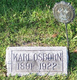


Dr Karl Edison Osborn
| Birth | : | 1 Oct 1891 Soldier, Jackson County, Kansas, USA |
| Death | : | 11 Jun 1922 Saint Joseph, Buchanan County, Missouri, USA |
| Burial | : | Myers Cemetery, Goshen, Clermont County, USA |
| Coordinate | : | 39.2236900, -84.1836300 |
| Plot | : | Section A east |
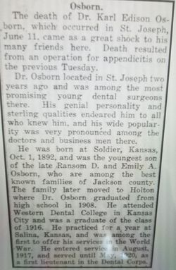
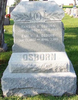
| Description | : | The death of Dr. Karl Edison Osborn, which occurred in St. Joseph, June 11 ... Death resulted from an operation for appendicitis on the previous Friday. Dr. Osborn located in St. Joseph two years ago and was among the most promising young dental surgeons there. ... He was born at Soldier, Kansas, Oct. 1, 1892, and was the youngest son of the late Ransom D. and Emily A. Osborn, who are among the best known families of Jackson county. The family later moved to Holton where Dr. Osborn graduated from high school in 1908. He attended Western Dental College in... Read More |
frequently asked questions (FAQ):
-
Where is Dr Karl Edison Osborn's memorial?
Dr Karl Edison Osborn's memorial is located at: Myers Cemetery, Goshen, Clermont County, USA.
-
When did Dr Karl Edison Osborn death?
Dr Karl Edison Osborn death on 11 Jun 1922 in Saint Joseph, Buchanan County, Missouri, USA
-
Where are the coordinates of the Dr Karl Edison Osborn's memorial?
Latitude: 39.2236900
Longitude: -84.1836300
Family Members:
Parent

Siblings
Flowers:


Nearby Cemetories:
1. Myers Cemetery
Goshen, Clermont County, USA
Coordinate: 39.2236900, -84.1836300
2. Irwin Cemetery
Goshen, Clermont County, USA
Coordinate: 39.2176850, -84.1543670
3. Goshen Cemetery
Goshen, Clermont County, USA
Coordinate: 39.2377300, -84.1579100
4. Graceland Memorial Gardens
Milford, Clermont County, USA
Coordinate: 39.1963997, -84.1999969
5. Stouder Cemetery
Goshen Township, Clermont County, USA
Coordinate: 39.2312700, -84.1335700
6. Union Cemetery
Branch Hill, Clermont County, USA
Coordinate: 39.2152850, -84.2409180
7. Tiger Cemetery
Pleasant Plain, Warren County, USA
Coordinate: 39.2694016, -84.1568985
8. Simpkins Family Cemetery
Williams Corners, Clermont County, USA
Coordinate: 39.1733900, -84.1532700
9. Paxton Cemetery
Loveland, Clermont County, USA
Coordinate: 39.2549000, -84.2433500
10. Mulberry Cemetery
Milford, Clermont County, USA
Coordinate: 39.1947784, -84.2469864
11. Murdoch Cemetery
Maineville, Warren County, USA
Coordinate: 39.2813988, -84.1986008
12. Ingle Cemetery
Pleasant Plain, Warren County, USA
Coordinate: 39.2699390, -84.1352750
13. Concord Methodist Episcopal Cemetery
Sundale, Clermont County, USA
Coordinate: 39.2318820, -84.2599380
14. Hill Family Cemetery
Stonelick, Clermont County, USA
Coordinate: 39.1622490, -84.1826090
15. Jewish Cemeteries of Greater Cincinnati – Loveland
Loveland, Clermont County, USA
Coordinate: 39.2281970, -84.2641830
16. Jones Cemetery
Pleasant Plain, Warren County, USA
Coordinate: 39.2644005, -84.1219025
17. Mount Zion Cemetery
Craver, Clermont County, USA
Coordinate: 39.1613464, -84.1940231
18. Shiloh Cemetery
Goshen, Clermont County, USA
Coordinate: 39.2328500, -84.1025500
19. Seyforth Cemetery
Loveland, Warren County, USA
Coordinate: 39.2743988, -84.2343979
20. Grailville Cemetery
Loveland, Warren County, USA
Coordinate: 39.2704290, -84.2434720
21. Ford Cemetery
Loveland, Warren County, USA
Coordinate: 39.2901830, -84.1813170
22. Plainview Cemetery
Newtonsville, Clermont County, USA
Coordinate: 39.1796989, -84.1177979
23. Prickett Cemetery
Newtonsville, Clermont County, USA
Coordinate: 39.1756700, -84.1188800
24. McCollum Cemetery
Wayne Township, Clermont County, USA
Coordinate: 39.2053980, -84.0968030