
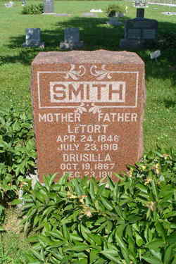
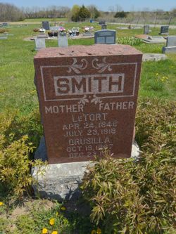
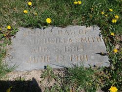
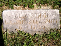
Drusilla Crapson Smith
| Birth | : | 19 Oct 1867 Schuyler County, Missouri, USA |
| Death | : | 23 Dec 1911 Chanute, Neosho County, Kansas, USA |
| Burial | : | River Dale Cemetery, Riverhead, Shelburne County, Canada |
| Coordinate | : | 43.5709930, -65.5878290 |
| Description | : | CHANUTE TIMES, DECEMBER 29, 1911 Druscilla Crapson was born in Schuyler county, Missouri October 19, 1867 and came to Chanute with her parents in 1869. She was married to L. T. Smith March, 1887 and died December 23, 1911 at the home of her sister in Chanute age 44 years, 2 months and 4 days. She leaves a husband and 6 children, 4 boys and 2 girls, one grandchild, a mother, five brothers, two sisters and a host of other relatives and friends to mourn her loss, she was loved and esteemed by all her knew her. She united with the... Read More |
frequently asked questions (FAQ):
-
Where is Drusilla Crapson Smith's memorial?
Drusilla Crapson Smith's memorial is located at: River Dale Cemetery, Riverhead, Shelburne County, Canada.
-
When did Drusilla Crapson Smith death?
Drusilla Crapson Smith death on 23 Dec 1911 in Chanute, Neosho County, Kansas, USA
-
Where are the coordinates of the Drusilla Crapson Smith's memorial?
Latitude: 43.5709930
Longitude: -65.5878290
Family Members:
Parent

Spouse

Siblings

Children
Flowers:


Nearby Cemetories:
1. River Dale Cemetery
Riverhead, Shelburne County, Canada
Coordinate: 43.5709930, -65.5878290
2. Barrington River Cemetery
Barrington, Shelburne County, Canada
Coordinate: 43.5667700, -65.5797000
3. Hillside Cemetery
Barrington, Shelburne County, Canada
Coordinate: 43.5520000, -65.6014667
4. Villagedale Cemetery
Villagedale, Shelburne County, Canada
Coordinate: 43.5379720, -65.5476840
5. Forest Hill Cemetery
Barrington Passage, Shelburne County, Canada
Coordinate: 43.5275000, -65.6091670
6. United Baptist Church Cemetery
Barrington Passage, Shelburne County, Canada
Coordinate: 43.5192870, -65.6316240
7. Atwoods Brook Cemetery - Old
Atwoods Brook, Shelburne County, Canada
Coordinate: 43.5036110, -65.6611110
8. Centreville Cemetery
Centreville, Shelburne County, Canada
Coordinate: 43.4842510, -65.6117500
9. Birch Hill Cemetery
Shelburne, Shelburne County, Canada
Coordinate: 43.4990405, -65.6608886
10. Port Clyde Cemetery
Port Clyde, Shelburne County, Canada
Coordinate: 43.5944429, -65.4657523
11. Ponds Cemetery
Port La Tour, Shelburne County, Canada
Coordinate: 43.4977020, -65.5054660
12. Hillside Cemetery
Cape Negro, Shelburne County, Canada
Coordinate: 43.5563700, -65.4534960
13. Saint Matthews Cemetery
Clyde River, Shelburne County, Canada
Coordinate: 43.6319900, -65.4779200
14. Camp Hill Cemetery
Port La Tour, Shelburne County, Canada
Coordinate: 43.5033050, -65.4845240
15. Atlantic Cemetery
Stoney Island, Shelburne County, Canada
Coordinate: 43.4681600, -65.5755600
16. Parkdale Cemetery
Upper Port La Tour, Shelburne County, Canada
Coordinate: 43.5156570, -65.4655722
17. Seaview Cemetery
Cape Negro, Shelburne County, Canada
Coordinate: 43.5540850, -65.4438020
18. Central Woods Harbour Cemetery
Central Woods Harbour, Shelburne County, Canada
Coordinate: 43.5335700, -65.7277500
19. Greenwood Cemetery
Lower Woods Harbour, Shelburne County, Canada
Coordinate: 43.5336390, -65.7279050
20. Mount Pleasant Cemetery
Woods Harbour, Shelburne County, Canada
Coordinate: 43.5672500, -65.7378200
21. Old Nickerson Family Graveyard
Central Woods Harbour, Shelburne County, Canada
Coordinate: 43.5572300, -65.7392110
22. Harbour View Cemetery
Port Saxon, Shelburne County, Canada
Coordinate: 43.5866700, -65.4284730
23. Forbes Family Cemetery
Forbes Point, Shelburne County, Canada
Coordinate: 43.5542950, -65.7495750
24. Old Farm Cemetery
Shag Harbour, Shelburne County, Canada
Coordinate: 43.4985969, -65.7252369