
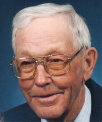

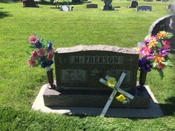
Earl Eugene McPherson
| Birth | : | 14 Dec 1909 Sturgis, Meade County, South Dakota, USA |
| Death | : | 22 Apr 2011 Sturgis, Meade County, South Dakota, USA |
| Burial | : | Saint Aloysius Cemetery, Sturgis, Meade County, USA |
| Coordinate | : | 44.4141340, -103.5193420 |
| Description | : | Earl Eugene McPherson died Friday, April 22, 2011 at the Sturgis Senior Care Center at the age of 101. He was born December 14, 1909 in Sturgis and made his first trip home, 27 miles by horse and buggy to the family ranch on Alkali creek in the middle of winter. He was the oldest son in a family of 8 children born to Eugene H. and Ida (Theirs) McPherson. Earl grew up on the family ranch helping his father raise working horses and cattle on their Alkali Creek ranch. He used to take horses with his Dad to many... Read More |
frequently asked questions (FAQ):
-
Where is Earl Eugene McPherson's memorial?
Earl Eugene McPherson's memorial is located at: Saint Aloysius Cemetery, Sturgis, Meade County, USA.
-
When did Earl Eugene McPherson death?
Earl Eugene McPherson death on 22 Apr 2011 in Sturgis, Meade County, South Dakota, USA
-
Where are the coordinates of the Earl Eugene McPherson's memorial?
Latitude: 44.4141340
Longitude: -103.5193420
Family Members:
Spouse
Siblings
Flowers:


Nearby Cemetories:
1. Saint Aloysius Cemetery
Sturgis, Meade County, USA
Coordinate: 44.4141340, -103.5193420
2. Bear Butte Cemetery
Sturgis, Meade County, USA
Coordinate: 44.4111595, -103.4947968
3. Fort Meade National Cemetery
Sturgis, Meade County, USA
Coordinate: 44.4021988, -103.4757996
4. Curley Grimes Memorial Cemetery
Sturgis, Meade County, USA
Coordinate: 44.3764500, -103.4691300
5. Black Hills National Cemetery
Sturgis, Meade County, USA
Coordinate: 44.3689003, -103.4753036
6. Crook City Cemetery
Crook City, Lawrence County, USA
Coordinate: 44.4432100, -103.6241500
7. Whitewood Cemetery
Whitewood, Lawrence County, USA
Coordinate: 44.4617820, -103.6330030
8. Oak Ridge Cemetery
Deadwood, Lawrence County, USA
Coordinate: 44.3891983, -103.6766968
9. Galena Cemetery
Galena, Lawrence County, USA
Coordinate: 44.3349220, -103.6438410
10. Anderson Cemetery
Lawrence County, USA
Coordinate: 44.4747009, -103.6896973
11. Saint Ambrose Cemetery
Deadwood, Lawrence County, USA
Coordinate: 44.3821983, -103.7266998
12. Mount Moriah Cemetery
Deadwood, Lawrence County, USA
Coordinate: 44.3760986, -103.7253036
13. Pleasant Valley Cemetery
Tilford, Meade County, USA
Coordinate: 44.3192500, -103.3531160
14. Little Dane Cemetery
Saint Onge, Lawrence County, USA
Coordinate: 44.5252500, -103.6705540
15. Roubaix Cemetery
Roubaix, Lawrence County, USA
Coordinate: 44.2789380, -103.6656600
16. South Lead Cemetery
Lead, Lawrence County, USA
Coordinate: 44.3478510, -103.7606260
17. Gate of Heaven Cemetery
Saint Onge, Lawrence County, USA
Coordinate: 44.5353000, -103.7237000
18. Piedmont Cemetery
Piedmont, Meade County, USA
Coordinate: 44.2425780, -103.3871730
19. West Lead Cemetery
Lead, Lawrence County, USA
Coordinate: 44.3484001, -103.7779999
20. Beals Cemetery
Vale, Butte County, USA
Coordinate: 44.6185989, -103.4366989
21. Vale Cemetery
Vale, Butte County, USA
Coordinate: 44.6138992, -103.4052963
22. Terry Cemetery
Terry, Lawrence County, USA
Coordinate: 44.3344290, -103.8165110
23. Nemo Cemetery
Nemo, Lawrence County, USA
Coordinate: 44.1872800, -103.5066410
24. Mountain Meadow Cemetery
Lawrence County, USA
Coordinate: 44.2038994, -103.6557999