
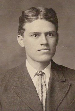

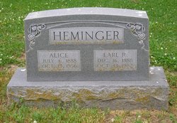
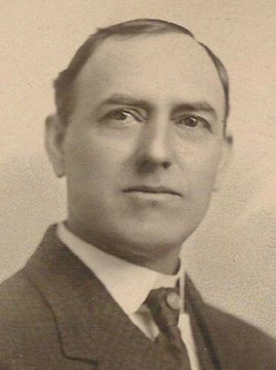
Earl Royster Heminger
| Birth | : | 16 Dec 1888 Buffalo, Wilson County, Kansas, USA |
| Death | : | 13 Oct 1982 Chanute, Neosho County, Kansas, USA |
| Burial | : | Eldon Cemetery, Eldon, Miller County, USA |
| Coordinate | : | 38.3642006, -92.5868988 |
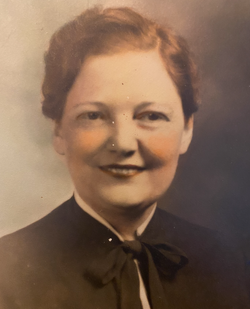
| Description | : | Earl was a very colorful character. Anyone who knew Earl understood that he was a man who knew and appreciated the value of hard work and thrift. He was well known in Chanute and surrounding area for his enterprising nature. Earl married Alice Mathews on Dec. 29, 1909 in Kansas City, MO. He apprenticed as a carpenter under the supervision of his father, John Calvin Heminger, and eventually moved on to the role of a building contractor and real estate developer. He was a member of the Nazarene Church, and a member of Masonic Cedar Lodge... Read More |
frequently asked questions (FAQ):
-
Where is Earl Royster Heminger's memorial?
Earl Royster Heminger's memorial is located at: Eldon Cemetery, Eldon, Miller County, USA.
-
When did Earl Royster Heminger death?
Earl Royster Heminger death on 13 Oct 1982 in Chanute, Neosho County, Kansas, USA
-
Where are the coordinates of the Earl Royster Heminger's memorial?
Latitude: 38.3642006
Longitude: -92.5868988
Family Members:
Parent
Spouse
Siblings
Flowers:


Nearby Cemetories:
1. Salem Cemetery
Eldon, Miller County, USA
Coordinate: 38.3697014, -92.5714035
2. Salem Cemetery
Saline Township, Miller County, USA
Coordinate: 38.3691232, -92.5697260
3. Mount Vernon Cemetery
Eldon, Miller County, USA
Coordinate: 38.3624992, -92.5606003
4. Taylor Cemetery
Eldon, Miller County, USA
Coordinate: 38.3443985, -92.6303024
5. Hite Cemetery
Miller County, USA
Coordinate: 38.4039001, -92.5935974
6. Mount Pleasant Cemetery
Eldon, Miller County, USA
Coordinate: 38.3667700, -92.5300800
7. Green Ridge Baptist Church Cemetery
Eldon, Miller County, USA
Coordinate: 38.4116200, -92.5645700
8. Dooley Cemetery
Eldon, Miller County, USA
Coordinate: 38.3191400, -92.6353500
9. Olean Cemetery
Olean, Miller County, USA
Coordinate: 38.4131012, -92.5413971
10. Greenmore Memorial Gardens
Barnett, Morgan County, USA
Coordinate: 38.3787155, -92.6676254
11. White Cemetery
Miller County, USA
Coordinate: 38.3408012, -92.6647034
12. Colburn Cemetery
Eldon, Miller County, USA
Coordinate: 38.4246300, -92.6275500
13. Artz-Wenzel Cemetery
Eldon, Miller County, USA
Coordinate: 38.2980995, -92.5622025
14. Phillips Cemetery
Barnett, Morgan County, USA
Coordinate: 38.4227982, -92.6367035
15. Etter-Walker Cemetery
Burris Fork, Moniteau County, USA
Coordinate: 38.4333700, -92.5525400
16. Walker Cemetery
Moniteau County, USA
Coordinate: 38.4338989, -92.5522003
17. Phillips Cemetery
High Point, Moniteau County, USA
Coordinate: 38.4430300, -92.6125300
18. Farris Cemetery
Moniteau County, USA
Coordinate: 38.4369900, -92.5380000
19. Allen Cemetery
Olean, Miller County, USA
Coordinate: 38.4150009, -92.5008011
20. Skinner Cemetery
Miller County, USA
Coordinate: 38.2806015, -92.5481033
21. Jackson Chapel Methodist Church Cemetery
California, Moniteau County, USA
Coordinate: 38.4447900, -92.5286500
22. Gray Cemetery
Moniteau County, USA
Coordinate: 38.4536018, -92.5456009
23. Blue Springs Cemetery
Eldon, Miller County, USA
Coordinate: 38.2778015, -92.6603012
24. Kelsay Cemetery
Miller County, USA
Coordinate: 38.2663994, -92.5397034