
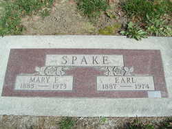
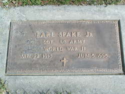
Earl Spake Sr.
| Birth | : | 14 Feb 1887 Rochester, Andrew County, Missouri, USA |
| Death | : | 24 Feb 1974 Chelan, Chelan County, Washington, USA |
| Burial | : | Saint Johns Cemetery, Lansford, Bottineau County, USA |
| Coordinate | : | 48.6314011, -101.3961029 |
| Plot | : | Row 5, Street Block 37, Lot 4 |
| Inscription | : | Mary E Spake |
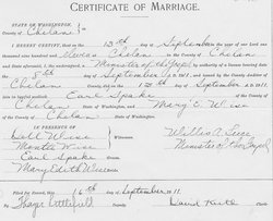
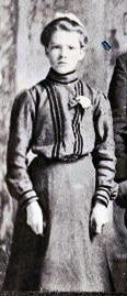
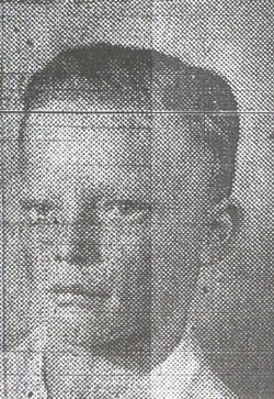
| Description | : | Earl Spake, 87, Manson, died Sunday at a Chelan hospital following a short illness. He was born on Feb. 14, 1887, at Rochester, Mo. In 1904 he moved to Union Valley with his family. He married Mary Edith Wise at Chelan on Sept. 13, 1911. They made their home there, while he was employed as a logger and in the orchards, until 1944, when they moved to Coeur d'Alene. In 1959, they moved to Lynnwood where they lived until 1966, when they returned to Manson. Surviving are five sons, Harry of Chelan, Burke of Pateros, Earl of Mountlake Terrace, and... Read More |
frequently asked questions (FAQ):
-
Where is Earl Spake Sr.'s memorial?
Earl Spake Sr.'s memorial is located at: Saint Johns Cemetery, Lansford, Bottineau County, USA.
-
When did Earl Spake Sr. death?
Earl Spake Sr. death on 24 Feb 1974 in Chelan, Chelan County, Washington, USA
-
Where are the coordinates of the Earl Spake Sr.'s memorial?
Latitude: 48.6314011
Longitude: -101.3961029
Family Members:
Parent
Spouse
Siblings
Children
Flowers:


Nearby Cemetories:
1. Saint Johns Cemetery
Lansford, Bottineau County, USA
Coordinate: 48.6314011, -101.3961029
2. Lansford Cemetery
Lansford, Bottineau County, USA
Coordinate: 48.6189003, -101.3867035
3. Shook Cemetery
Renville County, USA
Coordinate: 48.5419273, -101.3651505
4. Renville Cemetery
Renville, Bottineau County, USA
Coordinate: 48.7485900, -101.3220700
5. Grano Cemetery
Grano, Renville County, USA
Coordinate: 48.6136017, -101.6038971
6. Mohall Cemetery
Cut Bank Township, Bottineau County, USA
Coordinate: 48.7627983, -101.4850006
7. Brotherhood Cemetery
Bottineau County, USA
Coordinate: 48.7780991, -101.4736023
8. Saint Philomena Catholic Cemetery
Glenburn, Renville County, USA
Coordinate: 48.5110168, -101.2291183
9. Fairview Cemetery
Glenburn, Renville County, USA
Coordinate: 48.5099983, -101.2288971
10. Saint Henrys Cemetery
Renville County, USA
Coordinate: 48.4846992, -101.5108032
11. Graceland Cemetery
Maxbass, Bottineau County, USA
Coordinate: 48.7344017, -101.1363983
12. Lynch Immanuel Lutheran Church Cemetery
Ward County, USA
Coordinate: 48.4293213, -101.3009720
13. Our Saviors Cemetery
Eckman, Bottineau County, USA
Coordinate: 48.5459500, -101.1025900
14. Gethsemane Cemetery
Carpio, Ward County, USA
Coordinate: 48.5747261, -101.7124481
15. Riverside Cemetery
Eckman, Bottineau County, USA
Coordinate: 48.6315117, -101.0602493
16. Nazareth Lutheran Cemetery
Renville County, USA
Coordinate: 48.4733180, -101.6480450
17. Bethany Lutheran Cemetery
Minot, Ward County, USA
Coordinate: 48.4294000, -101.2133000
18. Holden Cemetery
Eckman, Bottineau County, USA
Coordinate: 48.6906776, -101.0336533
19. Bethel Lutheran Brethren Cemetery
Antler, Bottineau County, USA
Coordinate: 48.8720245, -101.3008423
20. Loraine Cemetery
Loraine, Renville County, USA
Coordinate: 48.8672000, -101.5627000
21. Haas Cemetery
Antler, Bottineau County, USA
Coordinate: 48.8931007, -101.3977966
22. Hamel Catholic Cemetery
Dunning, Bottineau County, USA
Coordinate: 48.7707930, -101.0599920
23. Saint Johns United Lutheran Cemetery
Mohall, Renville County, USA
Coordinate: 48.7928429, -101.7149429
24. Betania Cemetery
Brander Township, Bottineau County, USA
Coordinate: 48.7480060, -101.0259820