
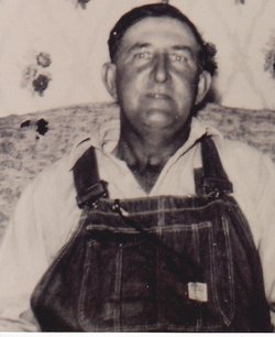
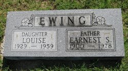
Earnest “Sam” Ewing
| Birth | : | 28 Nov 1900 Ingalls, Payne County, Oklahoma, USA |
| Death | : | 13 May 1978 Iola, Allen County, Kansas, USA |
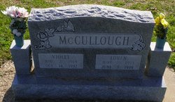
| Burial | : | Fairview Cemetery, Mildred, Allen County, USA |
| Coordinate | : | 38.0238020, -95.1401740 |
| Description | : | The Iola Register, Mon, May 15, 1978 Ernest S. Ewing, 77, of 225 North Third, died Saturday, May 13th, at the Allen County Hospital. He was born, Nov. 28, 1900, near Perry, Okla., and moved to the Mildred area with his parents at an early age. He worked most of his life for the railroad and was employed in the maintenance department of the Missouri Pacific Railroad here for a number of years. He retired in 1965. He was a member of the Community Baptist Church. He married Agnes Mae Tremain July 7, 1926. They divorced Dec.... Read More |
frequently asked questions (FAQ):
-
Where is Earnest “Sam” Ewing's memorial?
Earnest “Sam” Ewing's memorial is located at: Fairview Cemetery, Mildred, Allen County, USA.
-
When did Earnest “Sam” Ewing death?
Earnest “Sam” Ewing death on 13 May 1978 in Iola, Allen County, Kansas, USA
-
Where are the coordinates of the Earnest “Sam” Ewing's memorial?
Latitude: 38.0238020
Longitude: -95.1401740
Family Members:
Parent

Spouse
Siblings


Children


Flowers:


Nearby Cemetories:
1. Fairview Cemetery
Mildred, Allen County, USA
Coordinate: 38.0238020, -95.1401740
2. Osage Valley Cemetery
Mildred, Allen County, USA
Coordinate: 38.0313988, -95.0969009
3. Stanley Cemetery
Bayard, Allen County, USA
Coordinate: 37.9944200, -95.0970400
4. Gillham Cemetery
Allen County, USA
Coordinate: 37.9795100, -95.1103500
5. Kincaid Cemetery
Kincaid, Anderson County, USA
Coordinate: 38.0917015, -95.1513977
6. Mount Zion Cemetery
Kincaid, Anderson County, USA
Coordinate: 38.1046982, -95.1864014
7. Boulware Cemetery
Mapleton, Bourbon County, USA
Coordinate: 38.0264600, -95.0245400
8. Old Blue Mound Cemetery
Blue Mound, Linn County, USA
Coordinate: 38.0636600, -95.0249000
9. Entswood Cemetery
Bronson, Bourbon County, USA
Coordinate: 37.9431480, -95.0603200
10. Lone Elm Cemetery
Lone Elm, Anderson County, USA
Coordinate: 38.0882988, -95.2422028
11. Anderson Cemetery #1
Xenia, Bourbon County, USA
Coordinate: 37.9907700, -95.0025000
12. Pleasant View Cemetery
Blue Mound, Linn County, USA
Coordinate: 38.0952988, -95.0175018
13. Sunny Slope Cemetery
Blue Mound, Linn County, USA
Coordinate: 38.0952988, -95.0149994
14. Stevenson Cemetery
Mapleton, Bourbon County, USA
Coordinate: 38.0210991, -94.9847031
15. Moran Cemetery
Moran, Allen County, USA
Coordinate: 37.9068985, -95.1892014
16. Ozark Cemetery #1
Anderson County, USA
Coordinate: 38.0424200, -95.2992300
17. Bronson Cemetery
Bronson, Bourbon County, USA
Coordinate: 37.8997100, -95.0792500
18. Pleasant Valley Cemetery
Allen County, USA
Coordinate: 38.0093994, -95.3328018
19. Oakwood Cemetery
Centerville, Linn County, USA
Coordinate: 38.1605988, -95.0391998
20. Golden Valley Cemetery
Allen County, USA
Coordinate: 37.8792572, -95.2235718
21. Pleasant View Cemetery
Bronson, Bourbon County, USA
Coordinate: 37.8996900, -95.0040500
22. Northway Cemetery
Mapleton, Bourbon County, USA
Coordinate: 37.9935989, -94.9321976
23. Sugar Valley Cemetery
Anderson County, USA
Coordinate: 38.1903300, -95.1130200
24. La Harpe Cemetery
La Harpe, Allen County, USA
Coordinate: 37.9067001, -95.3022003