
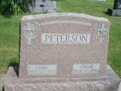
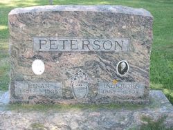
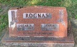
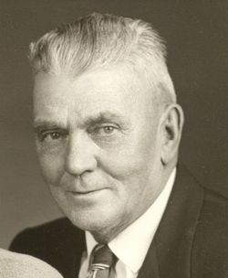
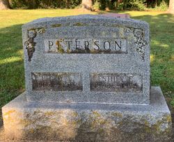
Edgar Peterson
| Birth | : | 12 Oct 1904 Iowa, USA |
| Death | : | 22 Feb 1984 Decorah, Winneshiek County, Iowa, USA |
| Burial | : | Saint Johns Catholic Cemetery, Foley, Benton County, USA |
| Coordinate | : | 45.6666985, -93.8989029 |
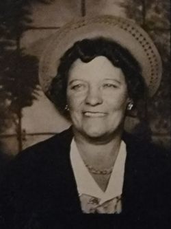
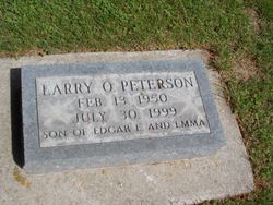
| Description | : | Edgar E. Peterson, 79, died Wednesday at his home. He was a retired farmer. Survivors are a son, Larry of Rochester, Minn.; and a sister, Mrs. Bill Lester of Los Angeles. Services: 1 p.m. Saturday at Hesper Lutheran Church, Hesper. Burial: Church Cemetery. Visitation after 2 p.m. today at Sensor-French’s and at the church from noon until service time. Source: Cedar Rapids Gazzette 24 Feb 1984 |
frequently asked questions (FAQ):
-
Where is Edgar Peterson's memorial?
Edgar Peterson's memorial is located at: Saint Johns Catholic Cemetery, Foley, Benton County, USA.
-
When did Edgar Peterson death?
Edgar Peterson death on 22 Feb 1984 in Decorah, Winneshiek County, Iowa, USA
-
Where are the coordinates of the Edgar Peterson's memorial?
Latitude: 45.6666985
Longitude: -93.8989029
Family Members:
Parent
Spouse
Siblings
Children
Flowers:


Nearby Cemetories:
1. Saint Johns Catholic Cemetery
Foley, Benton County, USA
Coordinate: 45.6666985, -93.8989029
2. Saint Pauls Lutheran Cemetery
Foley, Benton County, USA
Coordinate: 45.6670420, -93.8994690
3. Riverside Lutheran Cemetery
Ronneby, Benton County, USA
Coordinate: 45.6847000, -93.8685989
4. Maywood Cemetery
Ronneby, Benton County, USA
Coordinate: 45.6556015, -93.8153000
5. Saint Peter and Paul Catholic Cemetery
Gilman, Benton County, USA
Coordinate: 45.7359770, -93.9447680
6. Popple Creek Pioneer Cemetery
Foley, Benton County, USA
Coordinate: 45.6763600, -94.0110700
7. Mound Cemetery
Benton County, USA
Coordinate: 45.7340890, -93.8340570
8. Saint Johns Lutheran Cemetery
Popple Creek, Benton County, USA
Coordinate: 45.6656800, -94.0235600
9. Saint Lawrence Cemetery
Duelm, Benton County, USA
Coordinate: 45.5738983, -93.9356003
10. Estes Brook Cemetery
Mille Lacs County, USA
Coordinate: 45.6630280, -93.7602420
11. Estes Brook Evangelical Free Church Cemetery
Oak Park, Benton County, USA
Coordinate: 45.6630380, -93.7599000
12. Saint Francis River Cemetery
Duelm, Benton County, USA
Coordinate: 45.5671997, -93.8516998
13. United Church of Christ Cemetery
Sauk Rapids, Benton County, USA
Coordinate: 45.6325710, -94.0490520
14. Saint Patrick's Cemetery
Benton County, USA
Coordinate: 45.5827900, -94.0119700
15. Polish Church Cemetery
North Benton, Benton County, USA
Coordinate: 45.7811800, -93.9463900
16. Glendorado Lutheran Cemetery
Glendorado, Benton County, USA
Coordinate: 45.5819800, -93.7784500
17. Pilgrims Rest Cemetery
Foreston, Mille Lacs County, USA
Coordinate: 45.7228012, -93.7332993
18. Milo Cemetery
Mille Lacs County, USA
Coordinate: 45.6649370, -93.7082560
19. Saint Elizabeths Cemetery
Brennyville, Benton County, USA
Coordinate: 45.8079400, -93.9045400
20. Santiago Lutheran Cemetery
Santiago, Sherburne County, USA
Coordinate: 45.5289323, -93.8106766
21. Fairview Cemetery
Gilman, Benton County, USA
Coordinate: 45.8161011, -93.9366989
22. Our Savior Cemetery
Santiago, Sherburne County, USA
Coordinate: 45.5438889, -93.7708333
23. Saint Louis Cemetery
Foreston, Mille Lacs County, USA
Coordinate: 45.7305650, -93.7013720
24. Church of the Annunciation Cemetery
Mayhew, Benton County, USA
Coordinate: 45.7012634, -94.1152344