

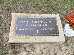
Edith Charbonnier Driver
| Birth | : | 17 Nov 1915 Pennsylvania, USA |
| Death | : | 7 Mar 2010 Germantown, Shelby County, Tennessee, USA |
| Burial | : | Silver Lake Cemetery, Athol, Worcester County, USA |
| Coordinate | : | 42.6018982, -72.2249985 |
| Plot | : | Sec G |
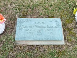
| Description | : | Mrs. Edith Charbonnier Miller Driver, 94, of Germantown, Tennessee passed away at her home on March 7, 2010. She attended Taylor University in Upland, Indiana and worked at the university for ten years before spending the remainder of her career at Brotherhood Mutual Company, attaining the title of Vice President before her retirement. She was very active in the Solteau-Morrow-Stevens Sunday School class and Triple L at First Evangelical Church in Memphis, Tennessee. Edith was preceded in death by husbands Luther Widrig Miller and Harvey Alan Driver. She is survived by her son Luther Charbonnier... Read More |
frequently asked questions (FAQ):
-
Where is Edith Charbonnier Driver's memorial?
Edith Charbonnier Driver's memorial is located at: Silver Lake Cemetery, Athol, Worcester County, USA.
-
When did Edith Charbonnier Driver death?
Edith Charbonnier Driver death on 7 Mar 2010 in Germantown, Shelby County, Tennessee, USA
-
Where are the coordinates of the Edith Charbonnier Driver's memorial?
Latitude: 42.6018982
Longitude: -72.2249985
Family Members:
Parent
Spouse
Flowers:


Nearby Cemetories:
1. Silver Lake Cemetery
Athol, Worcester County, USA
Coordinate: 42.6018982, -72.2249985
2. Old Burial Ground
Athol, Worcester County, USA
Coordinate: 42.5889840, -72.2270420
3. Mount Pleasant Cemetery
Athol, Worcester County, USA
Coordinate: 42.5943985, -72.2433014
4. Highland Cemetery
Athol, Worcester County, USA
Coordinate: 42.5889015, -72.2110977
5. Old Pleasant Street Cemetery
Athol, Worcester County, USA
Coordinate: 42.5860800, -72.2145100
6. Calvary Cemetery
Athol, Worcester County, USA
Coordinate: 42.5842018, -72.2117004
7. Chestnut Hill Cemetery
Athol, Worcester County, USA
Coordinate: 42.6296997, -72.2042007
8. Gethsemane Cemetery
Athol, Worcester County, USA
Coordinate: 42.5791960, -72.2578310
9. Jones Cemetery
Orange, Franklin County, USA
Coordinate: 42.6148224, -72.2728806
10. Tully Cemetery
Orange, Franklin County, USA
Coordinate: 42.6398000, -72.2504700
11. Ellinwood Cemetery
Athol, Worcester County, USA
Coordinate: 42.5589400, -72.2142600
12. North Orange Cemetery
Orange, Franklin County, USA
Coordinate: 42.6360230, -72.2690530
13. Maple Cemetery
Royalston, Worcester County, USA
Coordinate: 42.6545520, -72.2235460
14. Fay Cemetery
Athol, Worcester County, USA
Coordinate: 42.5466300, -72.2364200
15. Adams Road Cemetery
Athol, Worcester County, USA
Coordinate: 42.5425560, -72.2133610
16. Central Cemetery
Orange, Franklin County, USA
Coordinate: 42.5932960, -72.3066420
17. Stratton Cemetery
Athol, Worcester County, USA
Coordinate: 42.5407872, -72.2151265
18. New Sherborn Cemetery
Athol, Worcester County, USA
Coordinate: 42.5402985, -72.2166977
19. Riverside Cemetery
Royalston, Worcester County, USA
Coordinate: 42.6302986, -72.1453018
20. Nahum Greene Gravesite
Royalston, Worcester County, USA
Coordinate: 42.6545700, -72.1712900
21. South Cemetery
Orange, Franklin County, USA
Coordinate: 42.5657880, -72.3043410
22. Old Centre Cemetery
Royalston, Worcester County, USA
Coordinate: 42.6713982, -72.1889038
23. Lower Cemetery
Phillipston, Worcester County, USA
Coordinate: 42.5583000, -72.1425018
24. Harvard Cemetery
Petersham, Worcester County, USA
Coordinate: 42.5305000, -72.1896100