
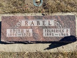
Edith M. Higgenbottom Rabel
| Birth | : | 24 Oct 1896 Pond Creek, Grant County, Oklahoma, USA |
| Death | : | 21 Dec 1972 Gage County, Nebraska, USA |
| Burial | : | Highland Cemetery, Adams, Gage County, USA |
| Coordinate | : | 40.4580994, -96.5196991 |
| Description | : | Beatrice Daily Sun, Beatrice, Nebraska, Thurs., Dec. 21, 1972, p. 2 (Newspapers.com image 507129145): "ADAMS -- Edith M. Rabel, 76, of Adams, passed away in a Lincoln hospital Thursday morning. She was born on Oct. 24, 1896, at Pond Creek, Okla., and had lived in Adams most of her life. Survivors include two sons, Roger R. Rabel of Lincoln, and Erwin Rabel of Miami, Okla.; a daughter, Mrs. Harlan (Verda) Baehr, Lincoln; three sisters, Mrs. Ben (Maude) Day, Vancouver, Wash., Mrs. Wilbur (Rosa) Young, Chester, Calif., and Mrs. Darrel (Beulah) Bacon, Vancouver, Wash.; and eight grandchildren. She was... Read More |
frequently asked questions (FAQ):
-
Where is Edith M. Higgenbottom Rabel's memorial?
Edith M. Higgenbottom Rabel's memorial is located at: Highland Cemetery, Adams, Gage County, USA.
-
When did Edith M. Higgenbottom Rabel death?
Edith M. Higgenbottom Rabel death on 21 Dec 1972 in Gage County, Nebraska, USA
-
Where are the coordinates of the Edith M. Higgenbottom Rabel's memorial?
Latitude: 40.4580994
Longitude: -96.5196991
Family Members:
Parent

Spouse

Siblings
Children
Flowers:


Nearby Cemetories:
1. Highland Cemetery
Adams, Gage County, USA
Coordinate: 40.4580994, -96.5196991
2. Hooker Cemetery
Adams, Gage County, USA
Coordinate: 40.4207993, -96.4732971
3. Grandview Cemetery
Gage County, USA
Coordinate: 40.4617004, -96.6091995
4. Granite Hill Cemetery
Johnson County, USA
Coordinate: 40.4180984, -96.4417038
5. Immanuel Cemetery
Sterling, Johnson County, USA
Coordinate: 40.4692001, -96.4253006
6. Latrobe Cemetery
Sterling, Johnson County, USA
Coordinate: 40.5151000, -96.4557000
7. Weber Cemetery
Sterling, Johnson County, USA
Coordinate: 40.4581000, -96.4177000
8. Saint Johns Lutheran Cemetery
Cortland, Gage County, USA
Coordinate: 40.5078300, -96.6252700
9. Firth Cemetery
Firth, Lancaster County, USA
Coordinate: 40.5250015, -96.6085968
10. Pella Cemetery
Panama, Lancaster County, USA
Coordinate: 40.5555992, -96.5014038
11. Saint John North Lutheran Cemetery
Sterling, Johnson County, USA
Coordinate: 40.4689500, -96.3878500
12. Sunnyside Cemetery
Cortland, Gage County, USA
Coordinate: 40.4799200, -96.6511800
13. South Saint John Lutheran Cemetery
Sterling, Johnson County, USA
Coordinate: 40.4355500, -96.3858000
14. Dietz Cemetery
Firth, Lancaster County, USA
Coordinate: 40.5449982, -96.6286011
15. Sterling Cemetery
Sterling, Johnson County, USA
Coordinate: 40.4585991, -96.3582993
16. Panama Cemetery
Panama, Lancaster County, USA
Coordinate: 40.5821991, -96.5255966
17. Zion Evangelical Lutheran Cemetery
Pickrell, Gage County, USA
Coordinate: 40.3456001, -96.6147003
18. Christ Lutheran Church Cemetery
Pickrell, Gage County, USA
Coordinate: 40.4079410, -96.6848370
19. Saint James Cemetery
Cortland, Gage County, USA
Coordinate: 40.4886050, -96.7036050
20. Cortland Cemetery
Cortland, Gage County, USA
Coordinate: 40.4879200, -96.7041250
21. Crab Orchard Cemetery
Crab Orchard, Johnson County, USA
Coordinate: 40.3274994, -96.4366989
22. Solon Cemetery
Otoe County, USA
Coordinate: 40.5917015, -96.4436035
23. Holland Cemetery
Holland, Lancaster County, USA
Coordinate: 40.5957985, -96.5997009
24. Rosehill Cemetery
Douglas, Otoe County, USA
Coordinate: 40.5845940, -96.3867900