

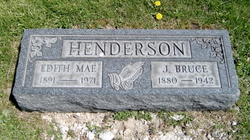
Edith Mae Parkinson Henderson
| Birth | : | 6 Jan 1891 Reynoldsburg, Franklin County, Ohio, USA |
| Death | : | 22 Jun 1971 Columbus, Franklin County, Ohio, USA |
| Burial | : | Saint Andrew Churchyard, Gorleston-on-Sea, Great Yarmouth Borough, England |
| Coordinate | : | 52.5788550, 1.7249070 |
| Plot | : | section F |
| Description | : | Wife of J. Bruce Henderson |
frequently asked questions (FAQ):
-
Where is Edith Mae Parkinson Henderson's memorial?
Edith Mae Parkinson Henderson's memorial is located at: Saint Andrew Churchyard, Gorleston-on-Sea, Great Yarmouth Borough, England.
-
When did Edith Mae Parkinson Henderson death?
Edith Mae Parkinson Henderson death on 22 Jun 1971 in Columbus, Franklin County, Ohio, USA
-
Where are the coordinates of the Edith Mae Parkinson Henderson's memorial?
Latitude: 52.5788550
Longitude: 1.7249070
Family Members:
Parent
Spouse
Flowers:


Nearby Cemetories:
1. Saint Andrew Churchyard
Gorleston-on-Sea, Great Yarmouth Borough, England
Coordinate: 52.5788550, 1.7249070
2. Gorleston Cemetery
Gorleston-on-Sea, Great Yarmouth Borough, England
Coordinate: 52.5786850, 1.7171760
3. Magdalen Lawn Cemetery
Great Yarmouth, Great Yarmouth Borough, England
Coordinate: 52.5719600, 1.7073100
4. Gorleston Crematorium
Gorleston-on-Sea, Great Yarmouth Borough, England
Coordinate: 52.5718100, 1.7044000
5. St Nicholas Churchyard
Bradwell, Great Yarmouth Borough, England
Coordinate: 52.5748650, 1.6928610
6. Black Friars Priory
Great Yarmouth, Great Yarmouth Borough, England
Coordinate: 52.6003760, 1.7285340
7. Colby Gate Jewish Burial Ground
Great Yarmouth, Great Yarmouth Borough, England
Coordinate: 52.6014625, 1.7310622
8. White Friars Carmelite Priory
Great Yarmouth, Great Yarmouth Borough, England
Coordinate: 52.6079960, 1.7233900
9. Dissenters' Grave Yard
Great Yarmouth, Great Yarmouth Borough, England
Coordinate: 52.6088420, 1.7279481
10. St Nicholas Churchyard
Great Yarmouth, Great Yarmouth Borough, England
Coordinate: 52.6109500, 1.7269100
11. Kitchener Road Cemetery
Great Yarmouth, Great Yarmouth Borough, England
Coordinate: 52.6125100, 1.7333200
12. Great Yarmouth New Cemetery
Great Yarmouth, Great Yarmouth Borough, England
Coordinate: 52.6151000, 1.7335100
13. All Saints Churchyard
Belton, Great Yarmouth Borough, England
Coordinate: 52.5674970, 1.6662540
14. St Margaret Churchyard
Hopton-on-Sea, Great Yarmouth Borough, England
Coordinate: 52.5395717, 1.7211316
15. Saint Margaret Old Churchyard
Hopton-on-Sea, Great Yarmouth Borough, England
Coordinate: 52.5387720, 1.7296733
16. St Peter and St Paul Churchyard
Burgh Castle, Great Yarmouth Borough, England
Coordinate: 52.5861230, 1.6542990
17. St John the Baptist Churchyard
Lound, Waveney District, England
Coordinate: 52.5310680, 1.6937750
18. Caister Road Roman Catholic Cemetery
Great Yarmouth, Great Yarmouth Borough, England
Coordinate: 52.6332800, 1.7284900
19. St Mary's Parish Churchyard
Ashby, Waveney District, England
Coordinate: 52.5322480, 1.6693690
20. St Bartholomew Churchyard
Corton, Waveney District, England
Coordinate: 52.5213100, 1.7404800
21. St Edmund's Churchyard
Fritton, Great Yarmouth Borough, England
Coordinate: 52.5430920, 1.6460460
22. St Mary The Virgin Churchyard
Blundeston, Waveney District, England
Coordinate: 52.5151100, 1.7029600
23. Corton War Memorial
Corton, Waveney District, England
Coordinate: 52.5148430, 1.7471340
24. Caister-on-Sea Cemetery
Caister-on-Sea, Great Yarmouth Borough, England
Coordinate: 52.6492100, 1.7248600