
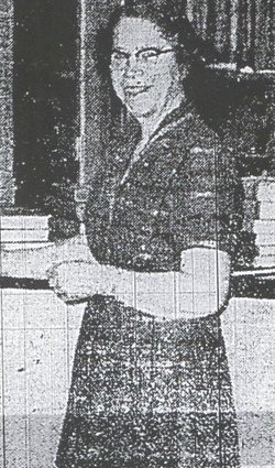

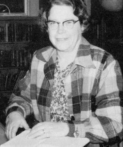
Edith Marjorie “Sunny” Hogan Ashmun
| Birth | : | 10 Dec 1908 Albany, Albany County, New York, USA |
| Death | : | 19 Sep 1983 Chelan, Chelan County, Washington, USA |
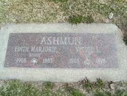
| Burial | : | Wessington Cemetery, Hand County, USA |
| Coordinate | : | 44.4569016, -98.7102966 |
| Plot | : | South Fraternal Row54 STBLK55 LN4 |
| Inscription | : | Victor L. "Vic" Ashmun |
| Description | : | E. Marjorie Ashmun, 74, of Manson, died Tuesday evening at Lake Chelan Community Hospital. She was born Marjorie Hogan on December 10, 1908, at Albany, New York. She was graduated from public school and the Albany Academy for Girls and attended the Yew York State College for Teachers. In 1927, she moved to Pullman and attended Washington State College. She received her Bachelor of Arts degree in 1930 and her Master of Arts degree in 1937. Mrs. Ashmun taught in Washington high schools for many years. From 1955 until failing health forced her retirement in 1973, she taught in Manson High... Read More |
frequently asked questions (FAQ):
-
Where is Edith Marjorie “Sunny” Hogan Ashmun's memorial?
Edith Marjorie “Sunny” Hogan Ashmun's memorial is located at: Wessington Cemetery, Hand County, USA.
-
When did Edith Marjorie “Sunny” Hogan Ashmun death?
Edith Marjorie “Sunny” Hogan Ashmun death on 19 Sep 1983 in Chelan, Chelan County, Washington, USA
-
Where are the coordinates of the Edith Marjorie “Sunny” Hogan Ashmun's memorial?
Latitude: 44.4569016
Longitude: -98.7102966
Family Members:
Spouse
Flowers:


Nearby Cemetories:
1. Wessington Cemetery
Hand County, USA
Coordinate: 44.4569016, -98.7102966
2. Saint Josephs Catholic Cemetery
Hand County, USA
Coordinate: 44.4574400, -98.7100400
3. McCord Cemetery
Wessington, Beadle County, USA
Coordinate: 44.3998500, -98.6673100
4. Sand Creek Cemetery
Beadle County, USA
Coordinate: 44.3055800, -98.6791200
5. Beulah Cemetery
Vayland, Hand County, USA
Coordinate: 44.6060982, -98.8060989
6. Saint Johns Lutheran Cemetery
Wolsey, Beadle County, USA
Coordinate: 44.3927994, -98.4985962
7. Rosehill Cemetery
Hand County, USA
Coordinate: 44.2980995, -98.7731018
8. Saint Lawrence Cemetery
Saint Lawrence, Hand County, USA
Coordinate: 44.5292015, -98.9321976
9. Wolsey Cemetery
Wolsey, Beadle County, USA
Coordinate: 44.4000015, -98.4546967
10. Saint Ann's Cemetery
Miller, Hand County, USA
Coordinate: 44.5222015, -98.9732971
11. G A R Cemetery
Miller, Hand County, USA
Coordinate: 44.5078011, -98.9858017
12. Bonilla Cemetery
Bonilla, Beadle County, USA
Coordinate: 44.5830994, -98.4835968
13. Molvig Cemetery
Virgil, Beadle County, USA
Coordinate: 44.2552900, -98.6145900
14. Hillcrest Cemetery
Miller, Hand County, USA
Coordinate: 44.5207000, -99.0006100
15. Garfield Cemetery
Spink County, USA
Coordinate: 44.6622009, -98.5535965
16. Buffalo Cemetery
Spink County, USA
Coordinate: 44.6918983, -98.6853027
17. Sunbeam Cemetery
Hand County, USA
Coordinate: 44.6777992, -98.8407974
18. Burdette Cemetery
Burdette, Hand County, USA
Coordinate: 44.7002983, -98.7869034
19. Earlville Cemetery
Beadle County, USA
Coordinate: 44.2118988, -98.6091995
20. Altoona Cemetery
Hitchcock, Beadle County, USA
Coordinate: 44.6108017, -98.4113998
21. New Zion Cemetery
Hand County, USA
Coordinate: 44.2043991, -98.8206024
22. Saint Johns Cemetery
Tulare, Spink County, USA
Coordinate: 44.7202988, -98.6600037
23. Virgil Cemetery
Virgil, Beadle County, USA
Coordinate: 44.2904800, -98.4176700
24. Broadland Catholic Cemetery
Broadland, Beadle County, USA
Coordinate: 44.5005000, -98.3380800