
| Birth | : | 27 Jul 1897 Mount Zion, Van Buren County, Iowa, USA |
| Death | : | 23 Nov 1985 Keosauqua, Van Buren County, Iowa, USA |
| Burial | : | Bath Union Workhouse Burial Ground, Bath, Bath and North East Somerset Unitary Authority, England |
| Coordinate | : | 51.3570889, -2.3773370 |
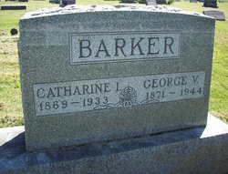
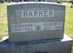
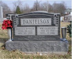
| Description | : | Edith Rebecca Dodds, daughter of George V. and Catherine McIntosh Barker was born July 27, 1897 near Mt. Zion and departed this life the evening of Saturday, November 23, 1985 at Van Buren Co., memorial hospital, Keosauqua at the age of 88. She attended Van Buren county schools and Parsons College in Fairfield and taught school for a time. On October 30, 1920 she married Ralph L. Dodds at Mt. Pleasant. They farmed in Harrisburg township north of Bonaparte. Mr. Dodds died May 18, 1968. Edith was baptized in the Mt. Zion Presbyterian Church and later joined the Harrisburg Baptist... Read More |
frequently asked questions (FAQ):
-
Where is Edith Rebecca Barker Dodds's memorial?
Edith Rebecca Barker Dodds's memorial is located at: Bath Union Workhouse Burial Ground, Bath, Bath and North East Somerset Unitary Authority, England.
-
When did Edith Rebecca Barker Dodds death?
Edith Rebecca Barker Dodds death on 23 Nov 1985 in Keosauqua, Van Buren County, Iowa, USA
-
Where are the coordinates of the Edith Rebecca Barker Dodds's memorial?
Latitude: 51.3570889
Longitude: -2.3773370
Family Members:
Parent
Spouse

Siblings

Children
Flowers:


Nearby Cemetories:
1. Bath Union Workhouse Burial Ground
Bath, Bath and North East Somerset Unitary Authority, England
Coordinate: 51.3570889, -2.3773370
2. Bath Union Workhouse Graveyard
Bath, Bath and North East Somerset Unitary Authority, England
Coordinate: 51.3584160, -2.3711140
3. St. James' Churchyard
South Stoke, Bath and North East Somerset Unitary Authority, England
Coordinate: 51.3497220, -2.3652780
4. Jewish Burial Ground
Combe Down, Bath and North East Somerset Unitary Authority, England
Coordinate: 51.3599170, -2.3534670
5. Combe Hay Cemetery
Combe Hay, Bath and North East Somerset Unitary Authority, England
Coordinate: 51.3397819, -2.3814323
6. Unitarian Chapel Burial Ground
Widcombe, Bath and North East Somerset Unitary Authority, England
Coordinate: 51.3704650, -2.3539270
7. Haycombe Cemetery and Crematorium
Bath, Bath and North East Somerset Unitary Authority, England
Coordinate: 51.3703430, -2.4014760
8. Combe Hay Parish Churchyard
Combe Hay, Bath and North East Somerset Unitary Authority, England
Coordinate: 51.3371120, -2.3817390
9. St Mary Magdalen Chapel
Widcombe, Bath and North East Somerset Unitary Authority, England
Coordinate: 51.3760486, -2.3643405
10. Union Chapel
Combe Down, Bath and North East Somerset Unitary Authority, England
Coordinate: 51.3594751, -2.3443662
11. St Peter Churchyard
Englishcombe, Bath and North East Somerset Unitary Authority, England
Coordinate: 51.3640600, -2.4088700
12. St John the Evangelist Cemetery
Bath, Bath and North East Somerset Unitary Authority, England
Coordinate: 51.3696700, -2.3487400
13. Prior Park College
Bath, Bath and North East Somerset Unitary Authority, England
Coordinate: 51.3645990, -2.3442400
14. Saint Mark's Churchyard
Widcombe, Bath and North East Somerset Unitary Authority, England
Coordinate: 51.3766660, -2.3588010
15. Bath Abbey Cemetery
Widcombe, Bath and North East Somerset Unitary Authority, England
Coordinate: 51.3712850, -2.3483060
16. Abbey & St James' Graveyard for the Poor
Widcombe, Bath and North East Somerset Unitary Authority, England
Coordinate: 51.3753550, -2.3545640
17. Old Baptist Burial Ground
Walcot, Bath and North East Somerset Unitary Authority, England
Coordinate: 51.3755070, -2.3544360
18. St. James' Cemetery
Bath, Bath and North East Somerset Unitary Authority, England
Coordinate: 51.3802000, -2.3722200
19. Twerton Cemetery
Twerton, Bath and North East Somerset Unitary Authority, England
Coordinate: 51.3802500, -2.3836220
20. Baptist Burial Ground
Widcombe, Bath and North East Somerset Unitary Authority, England
Coordinate: 51.3764216, -2.3556947
21. Quaker Burial Ground
Widcombe, Bath and North East Somerset Unitary Authority, England
Coordinate: 51.3744350, -2.3498460
22. St James Old Burial Ground
Bath, Bath and North East Somerset Unitary Authority, England
Coordinate: 51.3798600, -2.3610100
23. St Thomas à Becket's Church
Widcombe, Bath and North East Somerset Unitary Authority, England
Coordinate: 51.3734250, -2.3465560
24. Old Orchard Street Catholic Burial Vault
Bath, Bath and North East Somerset Unitary Authority, England
Coordinate: 51.3800370, -2.3579910