
| Birth | : | 12 Apr 1918 South Carolina, USA |
| Death | : | 12 Oct 2001 Richland County, South Carolina, USA |
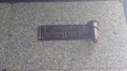
| Burial | : | Toowoomba Garden of Remembrance, Toowoomba, Toowoomba Region, Australia |
| Coordinate | : | -27.6072330, 151.9426800 |
| Description | : | COLUMBIA Edna Lewis Edna Earle Best Lewis, formerly of Florence, died Friday, Oct. 12, 2001, in Columbia after a long illness. She was a daughter of Jamie M. and Laura Wingard Best of Galivants Ferry. She was the oldest of nine children. She was predeceased by her husband of 55 years, Andrew Lee Lewis, who died in June 2001. She was a 1940 graduate of Columbia College, where she received a bachelor's of science degree in home economics. She taught school for almost 40 years, mostly in Florence School District 1. She taught thousands of young women the art and... Read More |
frequently asked questions (FAQ):
-
Where is Edna Earle Best Lewis's memorial?
Edna Earle Best Lewis's memorial is located at: Toowoomba Garden of Remembrance, Toowoomba, Toowoomba Region, Australia.
-
When did Edna Earle Best Lewis death?
Edna Earle Best Lewis death on 12 Oct 2001 in Richland County, South Carolina, USA
-
Where are the coordinates of the Edna Earle Best Lewis's memorial?
Latitude: -27.6072330
Longitude: 151.9426800
Family Members:
Parent

Spouse
Siblings
Flowers:


Nearby Cemetories:
1. Toowoomba Garden of Remembrance
Toowoomba, Toowoomba Region, Australia
Coordinate: -27.6072330, 151.9426800
2. Drayton Cemetery
Toowoomba Region, Australia
Coordinate: -27.5768740, 151.9546226
3. Drayton and Toowoomba Cemetery
Toowoomba, Toowoomba Region, Australia
Coordinate: -27.5768090, 151.9184880
4. St Patrick's Cathedral
Toowoomba Region, Australia
Coordinate: -27.5694185, 151.9533937
5. Westbrook Cemetery
Toowoomba Region, Australia
Coordinate: -27.6023480, 151.8005810
6. Highfields Baptist Church Cemetery
Highfields, Toowoomba Region, Australia
Coordinate: -27.4605410, 151.9449660
7. Glencoe Lawn Cemetery
Toowoomba Region, Australia
Coordinate: -27.4716670, 151.8744210
8. Glencoe Bethlehem Lutheran Congregational Cemetery
Toowoomba Region, Australia
Coordinate: -27.4700680, 151.8608750
9. Cabarlah Cemetery
Cabarlah, Toowoomba Region, Australia
Coordinate: -27.4513410, 151.9876760
10. Toowoomba Region Lone Graves
Toowoomba Region, Australia
Coordinate: -27.7082200, 151.7925340
11. Helidon Catholic Cemetery
Helidon, Lockyer Valley Region, Australia
Coordinate: -27.5456350, 152.1191570
12. Murphy's Creek Cemetery
Murphys Creek, Lockyer Valley Region, Australia
Coordinate: -27.4598700, 152.0405800
13. Greenmount Cemetery
Cambooya, Toowoomba Region, Australia
Coordinate: -27.7838780, 151.9306530
14. Helidon General Cemetery
Helidon, Lockyer Valley Region, Australia
Coordinate: -27.5488500, 152.1313000
15. Meringandan Cemetery
Meringandan, Toowoomba Region, Australia
Coordinate: -27.4255316, 151.8993308
16. Ma Ma Creek Anglican Cemetery
Ma Ma Creek, Lockyer Valley Region, Australia
Coordinate: -27.6294760, 152.1897330
17. Nobby Cemetery
Nobby, Toowoomba Region, Australia
Coordinate: -27.8322200, 151.8662000
18. Caffey Cemetery
Toowoomba, Toowoomba Region, Australia
Coordinate: -27.6964730, 152.2198720
19. Oakey Cemetery
Oakey, Toowoomba Region, Australia
Coordinate: -27.4327915, 151.7094802
20. Aubigny Catholic Cemetery
Aubigny, Toowoomba Region, Australia
Coordinate: -27.5251080, 151.6469360
21. Ropeley Lutheran Cemetery
Ropeley, Lockyer Valley Region, Australia
Coordinate: -27.6453990, 152.2538760
22. Aubigny Lutheran Cemetery
Aubigny, Toowoomba Region, Australia
Coordinate: -27.5226480, 151.6429360
23. Ingoldsby Lutheran Cemetery
Laidley, Lockyer Valley Region, Australia
Coordinate: -27.7083320, 152.2491290
24. Ropeley Scandinavian Lutheran Cemetery
Ropeley, Lockyer Valley Region, Australia
Coordinate: -27.6716340, 152.2626990