
| Birth | : | 20 Aug 1895 Salinas, Monterey County, California, USA |
| Death | : | 26 Oct 1964 Carmichael, Sacramento County, California, USA |
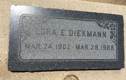
| Burial | : | San Ardo Cemetery, San Ardo, Monterey County, USA |
| Coordinate | : | 36.0269089, -120.9120941 |
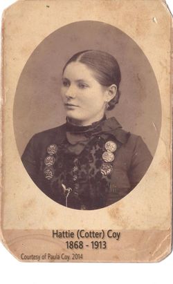
| Description | : | Edna May Coy, born to Hattie Cotter and Darwin Coy. Edna married Adolph (Adolfe) John Wittman in 1912, one year later their twin boys were born in San Ardo. Edna filed for divorce from John Wittman the following year on July 13, 1914. Within a few days her mother, Hattie passed away. Edna lived in Watsonville with her aunt, (Hattie Cotter's sister) until she tragically passed away from rectal cancer after complications from experimental surgery. Edna reconciled with her husband, but their marriage did not last. Edna then moved to... Read More |
frequently asked questions (FAQ):
-
Where is Edna May Coy Johnson's memorial?
Edna May Coy Johnson's memorial is located at: San Ardo Cemetery, San Ardo, Monterey County, USA.
-
When did Edna May Coy Johnson death?
Edna May Coy Johnson death on 26 Oct 1964 in Carmichael, Sacramento County, California, USA
-
Where are the coordinates of the Edna May Coy Johnson's memorial?
Latitude: 36.0269089
Longitude: -120.9120941
Family Members:
Parent

Spouse
Siblings
Children
Flowers:


Nearby Cemetories:
1. San Ardo Cemetery
San Ardo, Monterey County, USA
Coordinate: 36.0269089, -120.9120941
2. Paris Valley Cemetery
Monterey County, USA
Coordinate: 36.0230828, -120.9571273
3. Long Valley Cemetery
San Lucas, Monterey County, USA
Coordinate: 36.1467700, -120.9545100
4. San Lucas Cemetery
San Lucas, Monterey County, USA
Coordinate: 36.1258354, -121.0134735
5. Paulsen Cemetery
Monterey County, USA
Coordinate: 35.9663353, -121.0780716
6. Barbree Ranch Cemetery
San Lucas, Monterey County, USA
Coordinate: 36.0914030, -121.0822670
7. Gillett Family Cemetery
Lockwood, Monterey County, USA
Coordinate: 35.9362144, -121.0729828
8. Hames Valley Cemetery
Bradley, Monterey County, USA
Coordinate: 35.8644660, -120.8505700
9. Pleyto Cemetery
Monterey County, USA
Coordinate: 35.8645248, -121.0176468
10. Mansfield Cemetery
King City, Monterey County, USA
Coordinate: 36.1030320, -121.1478060
11. Dutton Hotel Burial Site
Jolon, Monterey County, USA
Coordinate: 35.9749220, -121.1757270
12. Jolon Cemetery
Jolon, Monterey County, USA
Coordinate: 35.9713478, -121.1769333
13. Clayton Cemetery
Priest Valley, San Benito County, USA
Coordinate: 36.2028008, -120.7285995
14. Gil Family Cemetery
Jolon, Monterey County, USA
Coordinate: 35.9609220, -121.1890660
15. King City Cemetery
King City, Monterey County, USA
Coordinate: 36.2066078, -121.1374207
16. Sierra Camp Cemetery
Jolon, Monterey County, USA
Coordinate: 35.9840900, -121.2285400
17. Williams-Duckworth Cemetery
Priest Valley, San Benito County, USA
Coordinate: 36.2356600, -120.7100800
18. Sands Cemetery
Bryson, Monterey County, USA
Coordinate: 35.7981840, -121.0882190
19. Mission San Antonio de Padua Cemetery
Monterey County, USA
Coordinate: 36.0153313, -121.2502441
20. Warthan Cemetery
Coalinga, Fresno County, USA
Coordinate: 36.0844180, -120.5279590
21. Mission San Miguel Cemetery
San Miguel, San Luis Obispo County, USA
Coordinate: 35.7452610, -120.6977370
22. Anderson Akers Cemetery
Coalinga, Fresno County, USA
Coordinate: 36.2642690, -120.6226220
23. San Miguel District Cemetery
San Miguel, San Luis Obispo County, USA
Coordinate: 35.7392006, -120.7013550
24. Imusdale Cemetery
Monterey County, USA
Coordinate: 35.9247017, -120.5074997