

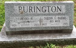
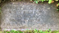
Edward Arthur “Bud” Purington
| Birth | : | 4 May 1926 Greenfield, Franklin County, Massachusetts, USA |
| Death | : | 25 Oct 2011 Colrain, Franklin County, Massachusetts, USA |
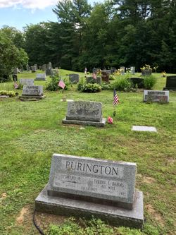
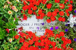
| Burial | : | Brick School Cemetery, Colrain, Franklin County, USA |
| Coordinate | : | 42.6641998, -72.6660995 |
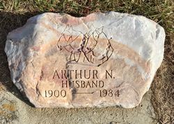
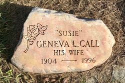
| Description | : | __________________________________________________ He married, first, on Nov 24,1949 at Claremont,NH, Evelyn (Kennison) Dahms. He married, second, on Jun 22,1974 at Colrain,MA, Myrtle Louise (Waite) Fish. Obituary -- Greenfield Recorder - Friday, October 28,2011: COLRAIN -- Edward "Bud" Arthur Purington, 85, of Colrain died on Tuesday (10-25-11) at home. Born on May 4, 1926 in Greenfield, he was the son of Arthur N. and Geneva (Call) Purington. Edward lived most of his life in Colrain. In his early years, he worked on the family farm in East Colrain, eventually buying the farm from his father.... Read More |
frequently asked questions (FAQ):
-
Where is Edward Arthur “Bud” Purington's memorial?
Edward Arthur “Bud” Purington's memorial is located at: Brick School Cemetery, Colrain, Franklin County, USA.
-
When did Edward Arthur “Bud” Purington death?
Edward Arthur “Bud” Purington death on 25 Oct 2011 in Colrain, Franklin County, Massachusetts, USA
-
Where are the coordinates of the Edward Arthur “Bud” Purington's memorial?
Latitude: 42.6641998
Longitude: -72.6660995
Family Members:
Parent
Spouse
Siblings
Flowers:


Nearby Cemetories:
1. Brick School Cemetery
Colrain, Franklin County, USA
Coordinate: 42.6641998, -72.6660995
2. Chandler Hill Cemetery
Colrain, Franklin County, USA
Coordinate: 42.6683006, -72.6832962
3. North River Cemetery
Colrain, Franklin County, USA
Coordinate: 42.6856003, -72.6917038
4. South Leyden Cemetery
Leyden, Franklin County, USA
Coordinate: 42.6831400, -72.6311200
5. Colrain West Branch Cemetery
Colrain, Franklin County, USA
Coordinate: 42.6671982, -72.7221985
6. West Leyden Cemetery
Leyden, Franklin County, USA
Coordinate: 42.7061005, -72.6572037
7. Country Farms Cemetery
Greenfield, Franklin County, USA
Coordinate: 42.6393900, -72.6165400
8. North Meadows Cemetery
Greenfield, Franklin County, USA
Coordinate: 42.6171989, -72.6333008
9. East Shelburne Cemetery
Shelburne, Franklin County, USA
Coordinate: 42.6105995, -72.6694031
10. East Hill Cemetery
Leyden, Franklin County, USA
Coordinate: 42.6931000, -72.6025009
11. Hessian Cemetery
Bernardston, Franklin County, USA
Coordinate: 42.6679174, -72.5897169
12. Beaver Meadow Cemetery
Leyden, Franklin County, USA
Coordinate: 42.7188988, -72.6183014
13. Hill Cemetery
Shelburne, Franklin County, USA
Coordinate: 42.5984344, -72.6878815
14. Arms Cemetery
Shelburne Falls, Franklin County, USA
Coordinate: 42.6166992, -72.7332993
15. Billings Cemetery
Guilford, Windham County, USA
Coordinate: 42.7353100, -72.6481800
16. Log Plain Cemetery
Greenfield, Franklin County, USA
Coordinate: 42.6378320, -72.5725800
17. Stark Cemetery
Guilford, Windham County, USA
Coordinate: 42.7402992, -72.6746979
18. Lower Meadow Cemetery
Greenfield, Franklin County, USA
Coordinate: 42.5945600, -72.6200300
19. Greenfield Hebrew Congregation Cemetery
Greenfield, Franklin County, USA
Coordinate: 42.6409410, -72.5653360
20. Groll Cemetery
Guilford, Windham County, USA
Coordinate: 42.7383400, -72.6331000
21. Bell Cemetery
Halifax, Windham County, USA
Coordinate: 42.7423800, -72.6972900
22. Henry Farm Cemetery
West Halifax, Windham County, USA
Coordinate: 42.7379712, -72.7132938
23. Baker Cemetery
Guilford, Windham County, USA
Coordinate: 42.7378006, -72.6160965
24. South Cemetery
Shelburne, Franklin County, USA
Coordinate: 42.5819016, -72.6699982