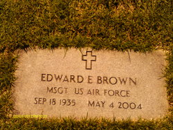
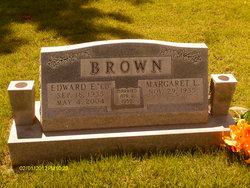
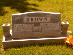
Edward E Brown
| Birth | : | 18 Sep 1935 |
| Death | : | 4 May 2004 Osage Beach, Camden County, Missouri, USA |
| Burial | : | Riverside Cemetery, Gas City, Grant County, USA |
| Coordinate | : | 40.4858017, -85.6226807 |
| Description | : | Jefferson City Post-Tribune, May 2004 Edward E. Brown, age 68, of Brumley, Mo., died Tuesday, May 4, 2004, in Osage Beach, Mo. Survivors include: his wife, Margaret Brown, of the home; three sons, Donald R. Brown of Urbana, Illinois, Gerald L. Brown and Steven E. Brown, both of Kaiser, Missouri; his father, Harley C. Brown of Osage Beach; two sisters, Ruby Irwin of Lake Ozark, and Ruth Faye Bartch of the state of Florida; and two step-grandchildren. Visitation will be held from 7-9 p.m. on Friday, May 7, at the Phillips Funeral Home, Eldon. Funeral services... Read More |
frequently asked questions (FAQ):
-
Where is Edward E Brown's memorial?
Edward E Brown's memorial is located at: Riverside Cemetery, Gas City, Grant County, USA.
-
When did Edward E Brown death?
Edward E Brown death on 4 May 2004 in Osage Beach, Camden County, Missouri, USA
-
Where are the coordinates of the Edward E Brown's memorial?
Latitude: 40.4858017
Longitude: -85.6226807
Family Members:
Parent
Spouse
Siblings
Flowers:
Nearby Cemetories:
1. Riverside Cemetery
Gas City, Grant County, USA
Coordinate: 40.4858017, -85.6226807
2. Walnut Creek Cemetery
Gas City, Grant County, USA
Coordinate: 40.4949570, -85.6062170
3. Gas City Cemetery
Gas City, Grant County, USA
Coordinate: 40.4803960, -85.6023840
4. Mount Hope Cemetery
Gas City, Grant County, USA
Coordinate: 40.5049591, -85.6156311
5. Griffin Cemetery
Home Corner, Grant County, USA
Coordinate: 40.5182037, -85.6174011
6. Deer Creek Cemetery
Marion, Grant County, USA
Coordinate: 40.4934769, -85.6685638
7. Bethel Cemetery
Jonesboro, Grant County, USA
Coordinate: 40.4557910, -85.5971240
8. Marion National Cemetery
Marion, Grant County, USA
Coordinate: 40.5237732, -85.6303406
9. Paxton Farm Cemetery
Grant County, USA
Coordinate: 40.5240288, -85.5993729
10. McCormick Cemetery
Jonesboro, Grant County, USA
Coordinate: 40.4546967, -85.5833054
11. Back Creek Friends Cemetery
Fairmount, Grant County, USA
Coordinate: 40.4450798, -85.6450119
12. Pet Rest Cemetery
Marion, Grant County, USA
Coordinate: 40.5314636, -85.6350555
13. Estates of Serenity
Marion, Grant County, USA
Coordinate: 40.5377500, -85.6396900
14. Park Cemetery
Fairmount, Grant County, USA
Coordinate: 40.4346008, -85.6447372
15. Puckett Cemetery
Marion, Grant County, USA
Coordinate: 40.5246544, -85.5733109
16. Foster Cemetery
Marion, Grant County, USA
Coordinate: 40.5409310, -85.6557460
17. Branson Cemetery
Marion, Grant County, USA
Coordinate: 40.5434850, -85.6485360
18. Grant Memorial Park
Marion, Grant County, USA
Coordinate: 40.5393982, -85.6757965
19. McKinney Lugar Creek Cemetery
Marion, Grant County, USA
Coordinate: 40.5388680, -85.5644150
20. Oak Ridge Cemetery
Liberty Township, Grant County, USA
Coordinate: 40.4368477, -85.6928635
21. Jefferson Cemetery
Upland, Grant County, USA
Coordinate: 40.4801941, -85.5239792
22. Burson Cemetery
Marion, Grant County, USA
Coordinate: 40.5531006, -85.5774994
23. Ballinger Cemetery
Upland, Grant County, USA
Coordinate: 40.4774437, -85.5230713
24. Gallatin Street Cemetery (Defunct)
Marion, Grant County, USA
Coordinate: 40.5567060, -85.6618150

