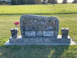
Edward Lewis “Ed” Stump
| Birth | : | 22 Aug 1956 Franklin, Franklin County, Nebraska, USA |
| Death | : | 4 Jan 2020 Funk, Phelps County, Nebraska, USA |
| Burial | : | Fridhem Cemetery, Funk, Phelps County, USA |
| Coordinate | : | 40.4678001, -99.2174988 |
| Description | : | Edward Lewis “Ed” Stump, 63 years of age, of Funk, passed away on Saturday, January 4, 2020, at his home in Funk surrounded by his family, after three and half years of battling cancer. Ed was born August 22, 1956, in Franklin, Nebraska, the eldest of five children to Edward “Duane” and Glenda Mae (Schriner) Stump. Ed received his primary education at Oxford, graduating from Oxford High School with the class of 1974. He then pursued higher education at Kearney State College in Kearney, Nebraska, and then received his Associates Degree from Central Community College in Grand... Read More |
frequently asked questions (FAQ):
-
Where is Edward Lewis “Ed” Stump's memorial?
Edward Lewis “Ed” Stump's memorial is located at: Fridhem Cemetery, Funk, Phelps County, USA.
-
When did Edward Lewis “Ed” Stump death?
Edward Lewis “Ed” Stump death on 4 Jan 2020 in Funk, Phelps County, Nebraska, USA
-
Where are the coordinates of the Edward Lewis “Ed” Stump's memorial?
Latitude: 40.4678001
Longitude: -99.2174988
Family Members:
Parent
Flowers:
Nearby Cemetories:
1. Fridhem Cemetery
Funk, Phelps County, USA
Coordinate: 40.4678001, -99.2174988
2. Salem Methodist Church Cemetery
Axtell, Kearney County, USA
Coordinate: 40.4528000, -99.1790000
3. Bethel Cemetery
Phelps County, USA
Coordinate: 40.4463997, -99.3031006
4. Pleasant Hill Cemetery
Axtell, Kearney County, USA
Coordinate: 40.4870000, -99.1235000
5. Bethphage Cemetery
Axtell, Kearney County, USA
Coordinate: 40.4882750, -99.1190130
6. Magill Cemetery
Phelps County, USA
Coordinate: 40.5539017, -99.2850037
7. Prairie Home Cemetery
Holdrege, Phelps County, USA
Coordinate: 40.4547005, -99.3491974
8. Bethany Cemetery
Axtell, Kearney County, USA
Coordinate: 40.4665413, -99.0843201
9. Wilcox Cemetery
Wilcox, Kearney County, USA
Coordinate: 40.3657990, -99.1511002
10. Keene Cemetery
Keene, Kearney County, USA
Coordinate: 40.4227700, -99.0747900
11. Zion Swedish Methodist Cemetery
Phelps County, USA
Coordinate: 40.3792000, -99.3202972
12. Keene Family Cemetery
Keene, Kearney County, USA
Coordinate: 40.4270500, -99.0658900
13. Mound Valley Cemetery
Blaine Township, Kearney County, USA
Coordinate: 40.5849341, -99.1428820
14. Antelope Cemetery
Ragan, Harlan County, USA
Coordinate: 40.3356018, -99.2557983
15. Saint Johns Cemetery
Franklin County, USA
Coordinate: 40.3222008, -99.1631012
16. Immanuel Lutheran Cemetery
Ragan, Harlan County, USA
Coordinate: 40.3352750, -99.3205050
17. Freewater Cemetery
Ragan, Harlan County, USA
Coordinate: 40.3083000, -99.2071991
18. Moses Hill Cemetery
Loomis, Phelps County, USA
Coordinate: 40.5104490, -99.4388600
19. Garden Plain Cemetery
Minden, Kearney County, USA
Coordinate: 40.3792000, -99.0186005
20. Industry Cemetery
Atlanta, Phelps County, USA
Coordinate: 40.4071999, -99.4419022
21. Saint Peters Cemetery
Hildreth, Franklin County, USA
Coordinate: 40.3280983, -99.0475006
22. Minden Cemetery
Minden, Kearney County, USA
Coordinate: 40.4950400, -98.9619900
23. Hildreth Cemetery
Hildreth, Franklin County, USA
Coordinate: 40.3293991, -99.0294037
24. White Hill Cemetery
Kearney County, USA
Coordinate: 40.5675011, -98.9805984


