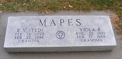
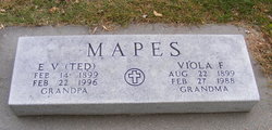
Edward Victor “Ted” Mapes
| Birth | : | 14 Feb 1899 Phillips, Hamilton County, Nebraska, USA |
| Death | : | 22 Feb 1996 Aurora, Hamilton County, Nebraska, USA |
| Burial | : | Cashmere Cemetery, Cashmere, Chelan County, USA |
| Coordinate | : | 47.5186996, -120.4869003 |
| Plot | : | 10A 24 |
| Description | : | Edward Victor "Ted" Mapes, the son of Benjamin and Louisa (Reinhard) Mapes, was born at Phillips, Nebraska, on February 14, 1899, and died at Aurora, Nebraska, on February 22, 1996, at the age of 97 years, and 8 days. He grew up on the family farm and received his education at Phillips. On December 23, 1918, he was united in marriage to Viola Sloan at the courthouse in Grand Island. Their first married years were spent farming in the Phillips area. Later, "Ted" worked on various projects including the building of Highway #11 to Ord. He also traveled... Read More |
frequently asked questions (FAQ):
-
Where is Edward Victor “Ted” Mapes's memorial?
Edward Victor “Ted” Mapes's memorial is located at: Cashmere Cemetery, Cashmere, Chelan County, USA.
-
When did Edward Victor “Ted” Mapes death?
Edward Victor “Ted” Mapes death on 22 Feb 1996 in Aurora, Hamilton County, Nebraska, USA
-
Where are the coordinates of the Edward Victor “Ted” Mapes's memorial?
Latitude: 47.5186996
Longitude: -120.4869003
Family Members:
Parent
Spouse
Siblings
Flowers:
Nearby Cemetories:
1. Brisky Treadwell Cemetery
Cashmere, Chelan County, USA
Coordinate: 47.5149770, -120.4955480
2. Old Missionary Indian Cemetery
Cashmere, Chelan County, USA
Coordinate: 47.5166000, -120.4493000
3. George W. Parrish Gravesite
Monitor, Chelan County, USA
Coordinate: 47.4688600, -120.4256400
4. Sunnyslope Church of the Brethren Cemetery
Sunnyslope, Chelan County, USA
Coordinate: 47.4784431, -120.3465576
5. Peshastin Cemetery
Peshastin, Chelan County, USA
Coordinate: 47.5828018, -120.6074982
6. Wenatchee City Cemetery
Wenatchee, Chelan County, USA
Coordinate: 47.4510994, -120.3463974
7. Mountain View Cemetery
Leavenworth, Chelan County, USA
Coordinate: 47.5546989, -120.6778030
8. Valley View Cemetery
Douglas County, USA
Coordinate: 47.4730988, -120.2981033
9. Jack Burpee Gravesite
Leavenworth, Chelan County, USA
Coordinate: 47.5947792, -120.6562080
10. Grace Lutheran Church Memorial Garden
Wenatchee, Chelan County, USA
Coordinate: 47.4233020, -120.3359630
11. Leavenworth North Road Cemetery
Leavenworth, Chelan County, USA
Coordinate: 47.6089410, -120.6458040
12. Leavenworth Cemetery
Leavenworth, Chelan County, USA
Coordinate: 47.5902778, -120.6719444
13. Blewett Cemetery
Chelan County, USA
Coordinate: 47.4249000, -120.6595000
14. Saint Lukes Episcopal Church Columbarium
Wenatchee, Chelan County, USA
Coordinate: 47.4220400, -120.3177260
15. Stutesman Family Cemetery
Leavenworth, Chelan County, USA
Coordinate: 47.6217100, -120.6508400
16. Home of Peace Mausoleum
Wenatchee, Chelan County, USA
Coordinate: 47.4124985, -120.3248978
17. William E. and LaDean C. Steward Memorial Garden
Wenatchee, Chelan County, USA
Coordinate: 47.4041166, -120.3248520
18. Pat King Burial Site
Wenatchee, Chelan County, USA
Coordinate: 47.3846940, -120.6553890
19. Ingalls Creek Cemetery
Peshastin, Chelan County, USA
Coordinate: 47.3827780, -120.6533340
20. Evergreen Memorial Park
East Wenatchee, Douglas County, USA
Coordinate: 47.4216995, -120.2649994
21. Hamilton Cemetery
East Wenatchee, Douglas County, USA
Coordinate: 47.4336014, -120.2482986
22. Badger Mountain Cemetery
Douglas County, USA
Coordinate: 47.5063000, -120.1938000
23. Entiat Cemetery
Entiat, Chelan County, USA
Coordinate: 47.6755981, -120.3043976
24. Orondo Community Cemetery
Orondo, Douglas County, USA
Coordinate: 47.6486015, -120.2136002


