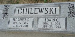
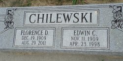
Edwin Clemens Chilewski
| Birth | : | 11 Nov 1909 Rockville, Sherman County, Nebraska, USA |
| Death | : | 23 Apr 1998 Loup City, Sherman County, Nebraska, USA |
| Burial | : | St Mary Magdalene Churchyard, Gillingham, Medway Unitary Authority, England |
| Coordinate | : | 51.3903530, 0.5622230 |
| Description | : | Son of John & Agnes (Goc) Chilewski. Married to Florence Badura on 10-28-1936 at Loup City, NE. Their farm was once known as that "pile of sand" because of its poor soil. However, Mr. Chilewski was given the Conservationist of the Year Award in 1949 by the Soil Conservation Service. The Omaha World-Herald also gave him a Service Award for his efforts in converting the land into a productive farm property within five years. |
frequently asked questions (FAQ):
-
Where is Edwin Clemens Chilewski's memorial?
Edwin Clemens Chilewski's memorial is located at: St Mary Magdalene Churchyard, Gillingham, Medway Unitary Authority, England.
-
When did Edwin Clemens Chilewski death?
Edwin Clemens Chilewski death on 23 Apr 1998 in Loup City, Sherman County, Nebraska, USA
-
Where are the coordinates of the Edwin Clemens Chilewski's memorial?
Latitude: 51.3903530
Longitude: 0.5622230
Family Members:
Parent
Spouse
Siblings
Children
Flowers:
Nearby Cemetories:
1. St Mary Magdalene Churchyard
Gillingham, Medway Unitary Authority, England
Coordinate: 51.3903530, 0.5622230
2. Grange Road Cemetery
Gillingham, Medway Unitary Authority, England
Coordinate: 51.3902512, 0.5639850
3. Woodlands Cemetery
Gillingham, Medway Unitary Authority, England
Coordinate: 51.3839989, 0.5680000
4. St. Barnabas Church
Gillingham, Medway Unitary Authority, England
Coordinate: 51.3801400, 0.5505370
5. St. Augustine's Church
Gillingham, Medway Unitary Authority, England
Coordinate: 51.3745050, 0.5474930
6. St George Churchyard
Chatham, Medway Unitary Authority, England
Coordinate: 51.3974070, 0.5346770
7. Chatham Naval Memorial
Chatham, Medway Unitary Authority, England
Coordinate: 51.3836479, 0.5321670
8. Brompton War Memorial
Chatham, Medway Unitary Authority, England
Coordinate: 51.3932140, 0.5293660
9. Christ Church Cemetery
Chatham, Medway Unitary Authority, England
Coordinate: 51.3716730, 0.5462690
10. Chatham Burial Ground
Chatham, Medway Unitary Authority, England
Coordinate: 51.3849900, 0.5272600
11. St Mary Churchyard
Chatham, Medway Unitary Authority, England
Coordinate: 51.3874550, 0.5244280
12. St. Werburgh Churchyard
Hoo St Werburgh, Medway Unitary Authority, England
Coordinate: 51.4176500, 0.5634340
13. Chatham Unitarian Church
Chatham, Medway Unitary Authority, England
Coordinate: 51.3826090, 0.5195850
14. St Philip and St James Churchyard
Upnor, Medway Unitary Authority, England
Coordinate: 51.4106250, 0.5250480
15. Chatham Palmerston Road Cemetery
Chatham, Medway Unitary Authority, England
Coordinate: 51.3678600, 0.5267300
16. Chatham Maidstone Road Cemetery
Chatham, Medway Unitary Authority, England
Coordinate: 51.3703300, 0.5227600
17. Fort Pitt Military Cemetery
Rochester, Medway Unitary Authority, England
Coordinate: 51.3769790, 0.5114570
18. Rochester Baptist Church
Rochester, Medway Unitary Authority, England
Coordinate: 51.3871570, 0.5052370
19. All Saints Churchyard
Frindsbury, Medway Unitary Authority, England
Coordinate: 51.4004440, 0.5058970
20. St Nicholas Churchyard
Rochester, Medway Unitary Authority, England
Coordinate: 51.3894170, 0.5035320
21. Rochester Cathedral
Rochester, Medway Unitary Authority, England
Coordinate: 51.3889750, 0.5031160
22. Rochester Castle Moat Burial Ground
Rochester, Medway Unitary Authority, England
Coordinate: 51.3894140, 0.5024580
23. St. Nicholas's Cemetery
Rochester, Medway Unitary Authority, England
Coordinate: 51.3780081, 0.5021076
24. St Margaret Churchyard
Rochester, Medway Unitary Authority, England
Coordinate: 51.3849380, 0.4993630

