
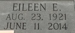


Eileen Emma “Bobbie” Theer Kohmetscher
| Birth | : | 23 Aug 1921 Lawrence, Nuckolls County, Nebraska, USA |
| Death | : | 11 Jun 2014 Hastings, Adams County, Nebraska, USA |
| Burial | : | Sacred Heart Cemetery, Lawrence, Nuckolls County, USA |
| Coordinate | : | 40.2921982, -98.2268982 |
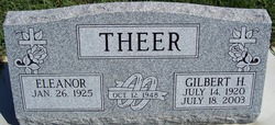
| Inscription | : | June 17, 1947 Parents of Richard Linda Susan Carl Julie Paul Jane |
| Description | : | The Lawrence Locomotive (Lawrence, NE), Thursday, June 26, 1947; pg. 1 THEER - KOHMETSCHER Miss Eileen Theer, the youngest daughter of Mr. and Mrs. Robert Theer, was united in marriage to Reynold Kohmetscher, son of Mr. and Mrs. Tony Kohmetscher, at Sacred Heart Church on Tuesday, June 17, at 8:30 in the morning. The Rt. Rev. Monsignor F.J. Kopecky officiated at the single ring ceremony and the Nuptial High Mass which followed. Miss Claudia Bishoff of Harvard, gowned in aqua, and Miss Joan Kahmetscher (sic), in yellow, were bridesmaids. Their gowns of nylon marqpisette (sic) fashioned... Read More |
frequently asked questions (FAQ):
-
Where is Eileen Emma “Bobbie” Theer Kohmetscher's memorial?
Eileen Emma “Bobbie” Theer Kohmetscher's memorial is located at: Sacred Heart Cemetery, Lawrence, Nuckolls County, USA.
-
When did Eileen Emma “Bobbie” Theer Kohmetscher death?
Eileen Emma “Bobbie” Theer Kohmetscher death on 11 Jun 2014 in Hastings, Adams County, Nebraska, USA
-
Where are the coordinates of the Eileen Emma “Bobbie” Theer Kohmetscher's memorial?
Latitude: 40.2921982
Longitude: -98.2268982
Family Members:
Parent
Spouse
Siblings

Flowers:


Nearby Cemetories:
1. Sacred Heart Cemetery
Lawrence, Nuckolls County, USA
Coordinate: 40.2921982, -98.2268982
2. Evergreen Cemetery
Lawrence, Nuckolls County, USA
Coordinate: 40.2922401, -98.2723236
3. Saint Stephens Cemetery
Nuckolls County, USA
Coordinate: 40.2544899, -98.2562485
4. Liberty Creek Cemetery
Nuckolls County, USA
Coordinate: 40.3361015, -98.2035980
5. OBanion Cemetery
Blue Hill, Webster County, USA
Coordinate: 40.2850000, -98.3020000
6. Hannum Graves
Lawrence, Nuckolls County, USA
Coordinate: 40.3456500, -98.1766800
7. Saint Martin-Loucky Cemetery
Deweese, Clay County, USA
Coordinate: 40.3652496, -98.1948624
8. Zion Cemetery
Webster County, USA
Coordinate: 40.2277985, -98.2921982
9. Union Cemetery
Nuckolls County, USA
Coordinate: 40.3146706, -98.1236877
10. Assumption Church Cemetery
Deweese, Clay County, USA
Coordinate: 40.3507000, -98.1324000
11. Rosemont Presbyterian Cemetery
Rosemont, Webster County, USA
Coordinate: 40.2775002, -98.3475037
12. Oak Creek Cemetery
Webster County, USA
Coordinate: 40.3436012, -98.3293991
13. Spring Ranch Cemetery
Clay County, USA
Coordinate: 40.4065100, -98.2484100
14. Saint Aloysius Cemetery
Deweese, Clay County, USA
Coordinate: 40.3932991, -98.1278000
15. Smith Cemetery
Nelson, Nuckolls County, USA
Coordinate: 40.3078003, -98.0567017
16. Eckley Cemetery
Webster County, USA
Coordinate: 40.2057991, -98.3581009
17. Salem Cemetery
Webster County, USA
Coordinate: 40.2341995, -98.3855972
18. Beaver Creek Cemetery
Webster County, USA
Coordinate: 40.1617012, -98.2882996
19. Emmanuel Lutheran Cemetery
Webster County, USA
Coordinate: 40.2057991, -98.3728027
20. Nelson Cemetery
Nelson, Nuckolls County, USA
Coordinate: 40.2056084, -98.0791702
21. Walker Cemetery
Blue Hill, Webster County, USA
Coordinate: 40.2881012, -98.4255981
22. Fairfield Cemetery
Fairfield, Clay County, USA
Coordinate: 40.4094009, -98.0982971
23. Monia Cemetery
Webster County, USA
Coordinate: 40.1605988, -98.3296967
24. Howe Cemetery
Webster County, USA
Coordinate: 40.2341730, -98.4154440