
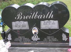
Elaine E. Schrader Breitbarth
| Birth | : | 4 Apr 1923 Cuming County, Nebraska, USA |
| Death | : | 26 Feb 2009 West Point, Cuming County, Nebraska, USA |
| Burial | : | Grandville Cemetery, Grandville, Kent County, USA |
| Coordinate | : | 42.9043999, -85.7514038 |
| Description | : | Daughter of Louis and Myrtle Kauffman Schrader. She entered Grace Lutheran Church through confirmation on April 10 1938. Elaine graduated from West Point High School with the class of 1941, and never missed an Alumni Banquet since. On June 27, 1943, Elaine married Harry J. Breitbarth at Grace Lutheran Church. The couple resided in West Point where Elaine worked, in the early years, at West Point Cold Storage, candling eggs. She worked many years in the newsroom at the West Point Democrat, and then at Bob's Bakery. Elaine enjoyed writing correspondence for the Norfolk Daily News, all the while providing... Read More |
frequently asked questions (FAQ):
-
Where is Elaine E. Schrader Breitbarth's memorial?
Elaine E. Schrader Breitbarth's memorial is located at: Grandville Cemetery, Grandville, Kent County, USA.
-
When did Elaine E. Schrader Breitbarth death?
Elaine E. Schrader Breitbarth death on 26 Feb 2009 in West Point, Cuming County, Nebraska, USA
-
Where are the coordinates of the Elaine E. Schrader Breitbarth's memorial?
Latitude: 42.9043999
Longitude: -85.7514038
Family Members:
Spouse
Flowers:


Nearby Cemetories:
1. Grandville Cemetery
Grandville, Kent County, USA
Coordinate: 42.9043999, -85.7514038
2. River Bend Cemetery
Walker, Kent County, USA
Coordinate: 42.9352989, -85.7750015
3. Jenison Cemetery
Jenison, Ottawa County, USA
Coordinate: 42.8897018, -85.8019028
4. Smallpox Cemetery
Georgetown Township, Ottawa County, USA
Coordinate: 42.8994500, -85.8063100
5. Floral View Memorial Gardens
Jenison, Ottawa County, USA
Coordinate: 42.8699989, -85.8032990
6. Resurrection Cemetery
Wyoming, Kent County, USA
Coordinate: 42.8905983, -85.6819000
7. Ridgeview Memorial Gardens
Georgetown Township, Ottawa County, USA
Coordinate: 42.8632600, -85.8023900
8. Hanley Cemetery
Jenison, Ottawa County, USA
Coordinate: 42.8565090, -85.7924940
9. Sleepy Hollow Pet Cemetery and Crematory
Byron Center, Kent County, USA
Coordinate: 42.8477040, -85.7329940
10. Holy Trinity Columbarium
Wyoming, Kent County, USA
Coordinate: 42.8669010, -85.6847490
11. Shackhuddle Cemetery
Georgetown Township, Ottawa County, USA
Coordinate: 42.8634460, -85.8229030
12. Boynton Cemetery
Byron Center, Kent County, USA
Coordinate: 42.8377991, -85.7433014
13. Saint Pauls Anglican Church Columbarium
Grand Rapids, Kent County, USA
Coordinate: 42.9711200, -85.7321700
14. Haire Cemetery
Jenison, Ottawa County, USA
Coordinate: 42.9363260, -85.8374910
15. Rosedale Memorial Park
Tallmadge Township, Ottawa County, USA
Coordinate: 42.9721160, -85.7876870
16. Georgetown Township Cemetery
Hudsonville, Ottawa County, USA
Coordinate: 42.8941710, -85.8519780
17. Lowing Cemetery
Jenison, Ottawa County, USA
Coordinate: 42.9219444, -85.8525000
18. Rest Lawn Memorial Park
Grand Rapids, Kent County, USA
Coordinate: 42.9007988, -85.6438980
19. Saint Andrews Catholic Cemetery
Grand Rapids, Kent County, USA
Coordinate: 42.9463997, -85.6567001
20. Oakhill Cemetery
Grand Rapids, Kent County, USA
Coordinate: 42.9411011, -85.6517029
21. Gerald R Ford Museum
Grand Rapids, Kent County, USA
Coordinate: 42.9668140, -85.6771000
22. Kent Memorial Gardens
Byron Center, Kent County, USA
Coordinate: 42.8356018, -85.6883011
23. Westminster Presbyterian Church Columbarium
Grand Rapids, Kent County, USA
Coordinate: 42.9619070, -85.6646760
24. Mount Calvary Cemetery
Grand Rapids, Kent County, USA
Coordinate: 42.9846992, -85.7043991