

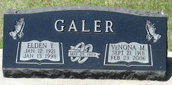
Elden Thomas Galer
| Birth | : | 12 Jan 1921 Springfield, Bon Homme County, South Dakota, USA |
| Death | : | 13 Jan 1998 Chandler, Maricopa County, Arizona, USA |
| Burial | : | L'Eau Qui Court Cemetery, Niobrara, Knox County, USA |
| Coordinate | : | 42.7458000, -98.0231018 |
| Description | : | Elden Thomas Galer, 77, of Chandler, a retired plumber and pipefitter, died Jan. 13, 1998. He was bom in Springfield, S.D. Survivors include his wife, VeNona; daughter, Jean Koster; sister, Annabelle Jardee; brother, Gerry; three grandchildren; and two great grandchildren. Services: 2 p.m. Thursday, Bueler Mortuary, 14 W. Hulet Drive, Chandler, with visitation at 1 p.m. ...Contributor: Duane Skeel (48892580) • |
frequently asked questions (FAQ):
-
Where is Elden Thomas Galer's memorial?
Elden Thomas Galer's memorial is located at: L'Eau Qui Court Cemetery, Niobrara, Knox County, USA.
-
When did Elden Thomas Galer death?
Elden Thomas Galer death on 13 Jan 1998 in Chandler, Maricopa County, Arizona, USA
-
Where are the coordinates of the Elden Thomas Galer's memorial?
Latitude: 42.7458000
Longitude: -98.0231018
Family Members:
Parent

Spouse
Flowers:


Nearby Cemetories:
1. L'Eau Qui Court Cemetery
Niobrara, Knox County, USA
Coordinate: 42.7458000, -98.0231018
2. Mormon Monument
Ponca, Knox County, USA
Coordinate: 42.7443000, -98.0632500
3. Ponka Tribal Cemetery
Knox County, USA
Coordinate: 42.7122700, -98.0830000
4. Bazile Creek Cemetery
Bazile Mills, Knox County, USA
Coordinate: 42.7377500, -97.9311500
5. Emanuel Cemetery
Springfield, Bon Homme County, USA
Coordinate: 42.8400002, -97.9903030
6. Kurka Family Cemetery
Dukesville, Knox County, USA
Coordinate: 42.6918000, -98.1374000
7. Ponca Evangelical Lutheran Cemetery
Niobrara, Knox County, USA
Coordinate: 42.7428000, -98.1621000
8. Riverview Cemetery
Knox County, USA
Coordinate: 42.7322006, -98.1619034
9. Pioneer Cemetery
Springfield, Bon Homme County, USA
Coordinate: 42.8513985, -98.0500031
10. Hillcrest Cemetery
Verdigre, Knox County, USA
Coordinate: 42.6356010, -98.0378036
11. Pleasant Hill Cemetery
Verdigre, Knox County, USA
Coordinate: 42.6837500, -98.1619500
12. Bethlehem Lutheran Cemetery
Springfield, Bon Homme County, USA
Coordinate: 42.8727989, -98.0494003
13. Saint Wenceslaus Cemetery
Verdigre, Knox County, USA
Coordinate: 42.6039009, -98.0428009
14. Riverside Cemetery
Verdigre, Knox County, USA
Coordinate: 42.6011009, -98.0286026
15. Ponca Valley Cemetery
Verdel, Knox County, USA
Coordinate: 42.8135000, -98.1990000
16. Springfield Cemetery
Springfield, Bon Homme County, USA
Coordinate: 42.8732986, -97.9132996
17. Saint Vincents Cemetery
Springfield, Bon Homme County, USA
Coordinate: 42.8744011, -97.9132996
18. Congregational Cemetery
Santee, Knox County, USA
Coordinate: 42.8330000, -97.8523000
19. Friedensberg Mennonite Cemetery
Avon, Bon Homme County, USA
Coordinate: 42.8958015, -98.0667038
20. Bohemian National Cemetery
Knox County, USA
Coordinate: 42.6178017, -98.1483002
21. Santee Mission Cemetery
Knox County, USA
Coordinate: 42.8408000, -97.8378200
22. Howe Creek Cemetery
Lindy, Knox County, USA
Coordinate: 42.6810000, -97.8127000
23. National Cemetery
Pishelville, Knox County, USA
Coordinate: 42.7190000, -98.2500000
24. Santee Catholic Cemetery
Santee, Knox County, USA
Coordinate: 42.8373000, -97.8287400