
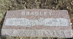
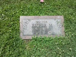
Eleanor Elizabeth Bohannon Bradley
| Birth | : | 19 Apr 1906 Holton, Jackson County, Kansas, USA |
| Death | : | 17 Jul 1969 USA |
| Burial | : | Rosebud Cemetery, Glenwood Springs, Garfield County, USA |
| Coordinate | : | 39.5168991, -107.3189011 |
| Plot | : | Section K |
| Description | : | Mrs. Eleanor Elizabeth Bradley, 63, route 1, Holton, died here Sunday in a hospital where she had been a patient about three months. Earlier she had been a patient in a Topeka hospital. She had cancer. She was born April 19, 1906 at Holton and spent most of her life in the Holton community. She served in the office of the Jackson county clerk 12 years before she retired last January. She was a member of the First Christian church, Columbian chapter No. 152, Order of Eastern Star, and Rebekah... Read More |
frequently asked questions (FAQ):
-
Where is Eleanor Elizabeth Bohannon Bradley's memorial?
Eleanor Elizabeth Bohannon Bradley's memorial is located at: Rosebud Cemetery, Glenwood Springs, Garfield County, USA.
-
When did Eleanor Elizabeth Bohannon Bradley death?
Eleanor Elizabeth Bohannon Bradley death on 17 Jul 1969 in USA
-
Where are the coordinates of the Eleanor Elizabeth Bohannon Bradley's memorial?
Latitude: 39.5168991
Longitude: -107.3189011
Family Members:
Parent

Spouse

Siblings
Children
Flowers:


Nearby Cemetories:
1. Rosebud Cemetery
Glenwood Springs, Garfield County, USA
Coordinate: 39.5168991, -107.3189011
2. Pioneer Cemetery
Glenwood Springs, Garfield County, USA
Coordinate: 39.5392000, -107.3192000
3. Farnum Holt Columbarium
Glenwood Springs, Garfield County, USA
Coordinate: 39.5469640, -107.3299900
4. Fisher Cemetery
Carbondale, Garfield County, USA
Coordinate: 39.4791985, -107.1911011
5. Evergreen Cemetery
Carbondale, Garfield County, USA
Coordinate: 39.4077988, -107.2155991
6. Marion Cemetery
Garfield County, USA
Coordinate: 39.3689003, -107.3047028
7. Hillcrest Cemetery
Carbondale, Garfield County, USA
Coordinate: 39.3922005, -107.1936035
8. Highland Cemetery
New Castle, Garfield County, USA
Coordinate: 39.5875015, -107.5192032
9. Dotsero Cemetery
Dotsero, Eagle County, USA
Coordinate: 39.6477600, -107.0672200
10. Union Divide Creek Cemetery
Silt, Garfield County, USA
Coordinate: 39.4508018, -107.6200027
11. Skyline Cemetery
Silt, Garfield County, USA
Coordinate: 39.5520060, -107.6575300
12. Basalt Cemetery
Basalt, Eagle County, USA
Coordinate: 39.3646800, -107.0213100
13. Cedar Hill Memorial Cemetery
Gypsum, Eagle County, USA
Coordinate: 39.6445990, -106.9600620
14. Wheatley Cemetery
Pitkin County, USA
Coordinate: 39.3325720, -106.9807170
15. Hillside Cemetery
Redstone, Pitkin County, USA
Coordinate: 39.1843300, -107.2418900
16. Rose Hill Cemetery
Rifle, Garfield County, USA
Coordinate: 39.5381012, -107.7742004
17. Saint Benedicts Monastery Cemetery
Snowmass, Pitkin County, USA
Coordinate: 39.2617000, -107.0038000
18. Sunset View Cemetery
Eagle, Eagle County, USA
Coordinate: 39.6510500, -106.8254400
19. Prospect Mountain Ranch Cemetery
Marble, Gunnison County, USA
Coordinate: 39.0927230, -107.2395980
20. Hidden Valley Cemetery
Snowmass Village, Pitkin County, USA
Coordinate: 39.2200690, -106.9181890
21. Snowmass Village Community Cemetery
Snowmass Village, Pitkin County, USA
Coordinate: 39.2200000, -106.9181000
22. Marble Cemetery
Marble, Gunnison County, USA
Coordinate: 39.0797005, -107.2277985
23. Collins Cemetery
Woody Creek, Pitkin County, USA
Coordinate: 39.2585040, -106.8480060
24. Rulison Cemetery
Rulison, Garfield County, USA
Coordinate: 39.4768000, -107.9357000