Elias Oliver Pruitt
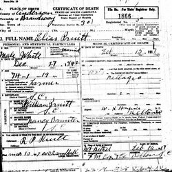
| Birth | : | 27 Dec 1842 Anderson County, South Carolina, USA |
| Death | : | 15 Feb 1917 Anderson County, South Carolina, USA |
| Burial | : | Mount Bethel Baptist Church Cemetery, Anderson, Anderson County, USA |
| Coordinate | : | 34.3972015, -82.4991989 |
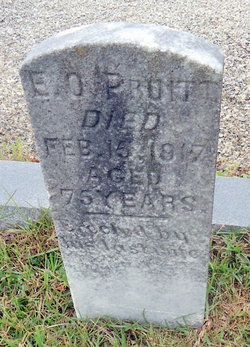
| Description | : | E. O. Pruitt on headstone. Died Feb. 15, 1917 at 75 years old. Name: Elias O. Pruitt Side: Confederate Regiment State/Origin: South Carolina Regiment Name: 20 South Carolina Infantry. Regiment Name Expanded: 20th Regiment, South Carolina Infantry |
frequently asked questions (FAQ):
-
Where is Elias Oliver Pruitt's memorial?
Elias Oliver Pruitt's memorial is located at: Mount Bethel Baptist Church Cemetery, Anderson, Anderson County, USA.
-
When did Elias Oliver Pruitt death?
Elias Oliver Pruitt death on 15 Feb 1917 in Anderson County, South Carolina, USA
-
Where are the coordinates of the Elias Oliver Pruitt's memorial?
Latitude: 34.3972015
Longitude: -82.4991989
Family Members:
Parent
Spouse
Siblings
Children
Flowers:
Nearby Cemetories:
1. Old Emerson Family Cemetery
Anderson, Anderson County, USA
Coordinate: 34.3975882, -82.5238359
2. Bethany Baptist Church Cemetery
Belton, Anderson County, USA
Coordinate: 34.4296989, -82.5081024
3. Pleasant Hill Baptist Church Cemetery
Belton, Anderson County, USA
Coordinate: 34.4366660, -82.5197780
4. Duncan Cemetery
Abbeville County, USA
Coordinate: 34.3642006, -82.4657974
5. Prince Family Cemetery
Due West, Abbeville County, USA
Coordinate: 34.3722610, -82.4549810
6. Williamson Family Cemetery
Belton, Anderson County, USA
Coordinate: 34.4437500, -82.5137833
7. Ebenezer United Methodist Church Cemetery
Anderson, Anderson County, USA
Coordinate: 34.3993988, -82.5586014
8. Rice Cemetery
Anderson County, USA
Coordinate: 34.4401300, -82.5335830
9. Armstrong Family Cemetery
Anderson County, USA
Coordinate: 34.4253170, -82.4438290
10. New Friendship Baptist Church Cemetery
Level Land, Abbeville County, USA
Coordinate: 34.3589300, -82.4520900
11. Long Branch Cemetery
Anderson, Anderson County, USA
Coordinate: 34.4380989, -82.5500031
12. Barkers Creek Baptist Church Cemetery
Honea Path, Anderson County, USA
Coordinate: 34.4359900, -82.4451200
13. Keowee Baptist Church Cemetery
Abbeville County, USA
Coordinate: 34.3888580, -82.4240890
14. Little River Baptist Church Cemetery
Level Land, Abbeville County, USA
Coordinate: 34.3460999, -82.4550018
15. Asaville Baptist Church Cemetery
Anderson, Anderson County, USA
Coordinate: 34.3491450, -82.5555750
16. Whispering Pines Mennonite Church Cemetery
Honea Path, Abbeville County, USA
Coordinate: 34.3671700, -82.4249650
17. Todd Family Cemetery
Belton, Anderson County, USA
Coordinate: 34.4622350, -82.5245180
18. Cedar Grove Baptist Church Cemetery
Belton, Anderson County, USA
Coordinate: 34.4646900, -82.4708870
19. Springfield Baptist Church Cemetery #1
Level Land, Abbeville County, USA
Coordinate: 34.3304570, -82.4683030
20. Shiloh Baptist Church Cemetery
Anderson, Anderson County, USA
Coordinate: 34.4018820, -82.5864280
21. First Creek Baptist Church Cemetery
Flat Rock, Anderson County, USA
Coordinate: 34.3378920, -82.5497800
22. Massey Family Cemetery
Honea Path, Anderson County, USA
Coordinate: 34.4534000, -82.4405170
23. Storeville Cemetery
Anderson County, USA
Coordinate: 34.3586274, -82.5797132
24. Antreville Church of God Cemetery
Antreville, Abbeville County, USA
Coordinate: 34.3295260, -82.5524240

