
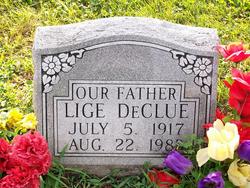
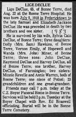
Elijah “Lige” DeClue
| Birth | : | 5 Jul 1917 Fredericktown, Madison County, Missouri, USA |
| Death | : | 22 Aug 1983 Bonne Terre, St. Francois County, Missouri, USA |
| Burial | : | Delphos Cemetery, Delphos, Ottawa County, USA |
| Coordinate | : | 39.2778015, -97.7416992 |
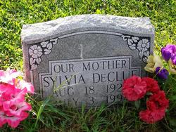
| Description | : | Husband of Sylvia Maude Cain Son of Samuel DeClue & Elizabeth Jackson |
frequently asked questions (FAQ):
-
Where is Elijah “Lige” DeClue's memorial?
Elijah “Lige” DeClue's memorial is located at: Delphos Cemetery, Delphos, Ottawa County, USA.
-
When did Elijah “Lige” DeClue death?
Elijah “Lige” DeClue death on 22 Aug 1983 in Bonne Terre, St. Francois County, Missouri, USA
-
Where are the coordinates of the Elijah “Lige” DeClue's memorial?
Latitude: 39.2778015
Longitude: -97.7416992
Family Members:
Parent
Spouse
Siblings
Children
Flowers:


Nearby Cemetories:
1. Delphos Cemetery
Delphos, Ottawa County, USA
Coordinate: 39.2778015, -97.7416992
2. Saint Paul Cemetery
Delphos, Ottawa County, USA
Coordinate: 39.2677994, -97.7518997
3. Bethel Cemetery
Meredith Township, Cloud County, USA
Coordinate: 39.3506000, -97.7029000
4. Hall Cemetery
Delphos, Ottawa County, USA
Coordinate: 39.2404970, -97.6302360
5. Crosson Cemetery
Minneapolis, Ottawa County, USA
Coordinate: 39.2011940, -97.6544720
6. Saint Marys Catholic Cemetery
Glasco, Cloud County, USA
Coordinate: 39.3574000, -97.8245000
7. Glasco Cemetery
Glasco, Cloud County, USA
Coordinate: 39.3574000, -97.8265000
8. Saint Peters Cemetery
Miltonvale, Cloud County, USA
Coordinate: 39.3652350, -97.6483570
9. Thomas Cemetery
Miltonvale, Cloud County, USA
Coordinate: 39.3300000, -97.5750000
10. Bohemian National Cemetery
Ada, Ottawa County, USA
Coordinate: 39.2193870, -97.9054030
11. Pleasant Hill Cemetery
Lamar, Ottawa County, USA
Coordinate: 39.2050018, -97.5832977
12. Baldwin Cemetery
Ottawa County, USA
Coordinate: 39.2061005, -97.9111023
13. Oakland Union Cemetery
Miltonvale, Cloud County, USA
Coordinate: 39.3647003, -97.5824966
14. Fairview Cemetery
Ada, Ottawa County, USA
Coordinate: 39.1610985, -97.8735962
15. Saint Borgia Cemetery
Ada, Ottawa County, USA
Coordinate: 39.1612050, -97.8739330
16. Fairview Cemetery
Lamar, Ottawa County, USA
Coordinate: 39.2928009, -97.5299988
17. Highland Cemetery
Minneapolis, Ottawa County, USA
Coordinate: 39.1175003, -97.6877975
18. Pleasant Hill Cemetery
Henry Township, Ottawa County, USA
Coordinate: 39.1183014, -97.8078003
19. Hall Cemetery
Cloud County, USA
Coordinate: 39.4455986, -97.7033005
20. Enterprise Cemetery
Cloud County, USA
Coordinate: 39.4230995, -97.6106033
21. Simpson Cemetery
Simpson, Mitchell County, USA
Coordinate: 39.3633003, -97.9471970
22. Coursen Grove Cemetery
Simpson, Mitchell County, USA
Coordinate: 39.3060989, -97.9792023
23. Kindel Cemetery
Center Township, Cloud County, USA
Coordinate: 39.4519005, -97.6464005
24. Green Mound Cemetery
Asherville, Mitchell County, USA
Coordinate: 39.3203011, -97.9858017