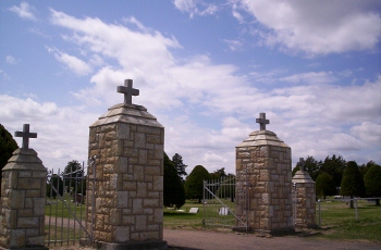
| Memorials | : | 276 |
| Location | : | Glasco, Cloud County, USA |
| Coordinate | : | 39.3574000, -97.8245000 |
| Description | : | The Sun, Glasco, Kansas, Saturday, March 28, 1891, page 1: Surveyor Doran was over from Clyde last Friday and Saturday laying out the new Catholic Cemetery. The Society bought three acres of ground of Mr. Horn, joining the Glasco Cemetery on the east, for $150. The Catholics living in this vicinity will remove the remains of their dead from the old Delphos burying ground which had to be abandoned on account of the railroad passing through it, to this one. As this ground has been in cultivation for a number of years, it can easily be improved and... Read More |
frequently asked questions (FAQ):
-
Where is Saint Marys Catholic Cemetery?
Saint Marys Catholic Cemetery is located at Glasco, Cloud County ,Kansas ,USA.
-
Saint Marys Catholic Cemetery cemetery's updated grave count on graveviews.com?
270 memorials
-
Where are the coordinates of the Saint Marys Catholic Cemetery?
Latitude: 39.3574000
Longitude: -97.8245000
Nearby Cemetories:
1. Glasco Cemetery
Glasco, Cloud County, USA
Coordinate: 39.3574000, -97.8265000
2. Bethel Cemetery
Meredith Township, Cloud County, USA
Coordinate: 39.3506000, -97.7029000
3. Simpson Cemetery
Simpson, Mitchell County, USA
Coordinate: 39.3633003, -97.9471970
4. Delphos Cemetery
Delphos, Ottawa County, USA
Coordinate: 39.2778015, -97.7416992
5. Saint Paul Cemetery
Delphos, Ottawa County, USA
Coordinate: 39.2677994, -97.7518997
6. Morrison Cemetery
Center Township, Cloud County, USA
Coordinate: 39.4817009, -97.7975006
7. Asherville Cemetery
Asherville, Mitchell County, USA
Coordinate: 39.4205000, -97.9672900
8. Summit Cemetery
Jamestown, Cloud County, USA
Coordinate: 39.4813200, -97.8628800
9. Hall Cemetery
Cloud County, USA
Coordinate: 39.4455986, -97.7033005
10. Green Mound Cemetery
Asherville, Mitchell County, USA
Coordinate: 39.3203011, -97.9858017
11. Coursen Grove Cemetery
Simpson, Mitchell County, USA
Coordinate: 39.3060989, -97.9792023
12. Saint Peters Cemetery
Miltonvale, Cloud County, USA
Coordinate: 39.3652350, -97.6483570
13. Bell-Bogardus Cemetery
Asherville, Mitchell County, USA
Coordinate: 39.4242410, -97.9919970
14. Bohemian National Cemetery
Ada, Ottawa County, USA
Coordinate: 39.2193870, -97.9054030
15. Wilcox Cemetery
Cloud County, USA
Coordinate: 39.4925003, -97.7313995
16. West Asher Cemetery
Scottsville, Mitchell County, USA
Coordinate: 39.4815000, -97.9661600
17. Baldwin Cemetery
Ottawa County, USA
Coordinate: 39.2061005, -97.9111023
18. Kindel Cemetery
Center Township, Cloud County, USA
Coordinate: 39.4519005, -97.6464005
19. Smith Cemetery
Asherville, Mitchell County, USA
Coordinate: 39.4516690, -98.0098850
20. Enterprise Cemetery
Cloud County, USA
Coordinate: 39.4230995, -97.6106033
21. McBride Cemetery
Beloit, Mitchell County, USA
Coordinate: 39.4808006, -97.9907990
22. Shiloh Cemetery
Beloit, Mitchell County, USA
Coordinate: 39.3574982, -98.0594025
23. Summit Cemetery #3
Macyville, Cloud County, USA
Coordinate: 39.5258330, -97.9194440
24. Oakland Union Cemetery
Miltonvale, Cloud County, USA
Coordinate: 39.3647003, -97.5824966

