
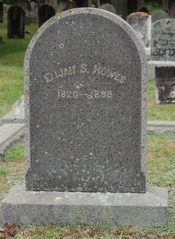
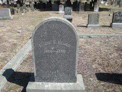
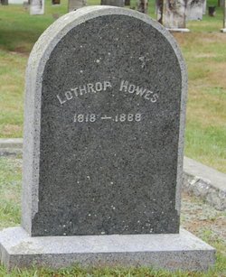
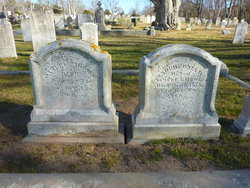
Elijah Smith Howes
| Birth | : | 14 Aug 1820 |
| Death | : | 1898 |
| Burial | : | Dennis Village Cemetery, Dennis, Barnstable County, USA |
| Coordinate | : | 41.7373466, -70.1924286 |
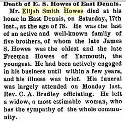
| Description | : | Name: Elijah Smith Howes Gender: Male Christening Date: Christening Place: , DENNIS, BARNSTABLE, MASSACHUSETTS Birth Date: 14 Aug 1820 Birthplace: , DENNIS, BARNSTABLE, MASSACHUSETTS Death Date: Name Note: Race: Father's Name: Lothrop Howes Father's Birthplace: Father's Age: Mother's Name: Elizabeth Mother's Birthplace: Mother's Age: Indexing Project (Batch) Number: C51041-3 System Origin: Massachusetts-VR GS Film number: 945518 Reference ID: 2:17514MR Citing this Record "Massachusetts, Births and Christenings, 1639-1915," index, FamilySearch (https://familysearch.org/pal:/MM9.1.1/FC39-VD4 : accessed 28 Mar 2013), Elijah Smith Howes, 14 Aug 1820. ** 1880 census Name: Elijah S. Howes Event Type: Census Event Date: 1880 Event Place:... Read More |
frequently asked questions (FAQ):
-
Where is Elijah Smith Howes's memorial?
Elijah Smith Howes's memorial is located at: Dennis Village Cemetery, Dennis, Barnstable County, USA.
-
When did Elijah Smith Howes death?
Elijah Smith Howes death on 1898 in
-
Where are the coordinates of the Elijah Smith Howes's memorial?
Latitude: 41.7373466
Longitude: -70.1924286
Family Members:
Parent

Spouse
Siblings
Flowers:


Nearby Cemetories:
1. Dennis Village Cemetery
Dennis, Barnstable County, USA
Coordinate: 41.7373466, -70.1924286
2. Hall Cemetery
Dennis, Barnstable County, USA
Coordinate: 41.7435989, -70.1943970
3. Howes Family Cemetery
Dennis, Barnstable County, USA
Coordinate: 41.7344017, -70.2014008
4. Nobscusset Indian Burial Ground
Dennis, Barnstable County, USA
Coordinate: 41.7451330, -70.1830350
5. Corporation Beach Memorial Park
Dennis, Barnstable County, USA
Coordinate: 41.7507000, -70.1875000
6. Paddock Cemetery
East Dennis, Barnstable County, USA
Coordinate: 41.7430992, -70.1735992
7. Worden Cemetery
East Dennis, Barnstable County, USA
Coordinate: 41.7425003, -70.1517029
8. Bass Hole Memorial Garden
Yarmouth Port, Barnstable County, USA
Coordinate: 41.7228810, -70.2355470
9. Sears Cemetery
West Brewster, Barnstable County, USA
Coordinate: 41.7442017, -70.1457977
10. Quaker Cemetery
Dennis, Barnstable County, USA
Coordinate: 41.7043991, -70.1713028
11. Oak Ridge Cemetery
South Dennis, Barnstable County, USA
Coordinate: 41.7111015, -70.1556015
12. Quivet Neck Cemetery
East Dennis, Barnstable County, USA
Coordinate: 41.7500000, -70.1417007
13. Ancient Cemetery
Yarmouth Port, Barnstable County, USA
Coordinate: 41.7111015, -70.2332993
14. Red Top Cemetery
Brewster, Barnstable County, USA
Coordinate: 41.7433014, -70.1342010
15. Thacher Property Burial Ground
Yarmouth Port, Barnstable County, USA
Coordinate: 41.7084800, -70.2438500
16. Ancient Cemetery
South Dennis, Barnstable County, USA
Coordinate: 41.6892014, -70.1568985
17. Woodside Cemetery
Yarmouth Port, Barnstable County, USA
Coordinate: 41.7000008, -70.2472000
18. Dillingham Cemetery
Brewster, Barnstable County, USA
Coordinate: 41.7444000, -70.1183014
19. Memorial Park
South Yarmouth, Barnstable County, USA
Coordinate: 41.6776350, -70.1925520
20. Georgetown Cemetery
South Yarmouth, Barnstable County, USA
Coordinate: 41.6731415, -70.1818695
21. Indian Memorial Cemetery
South Yarmouth, Barnstable County, USA
Coordinate: 41.6704400, -70.1913900
22. North Harwich Cemetery
North Harwich, Barnstable County, USA
Coordinate: 41.6956700, -70.1221700
23. South Dennis Cemetery
South Dennis, Barnstable County, USA
Coordinate: 41.6761017, -70.1556015
24. Quaker Meeting House Cemetery
South Yarmouth, Barnstable County, USA
Coordinate: 41.6689987, -70.1846008