
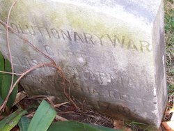
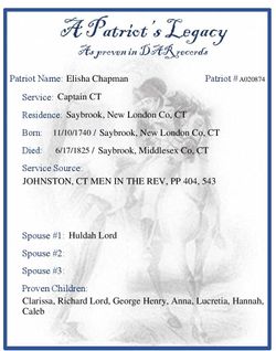
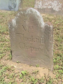
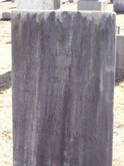
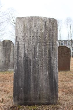
Elisha Chapman
| Birth | : | 10 Nov 1740 Old Saybrook, Middlesex County, Connecticut, USA |
| Death | : | 17 Jun 1825 Old Saybrook, Middlesex County, Connecticut, USA |
| Burial | : | Rock Creek Cemetery, Meroa, Mitchell County, USA |
| Coordinate | : | 43.2352791, -92.9225006 |
frequently asked questions (FAQ):
-
Where is Elisha Chapman's memorial?
Elisha Chapman's memorial is located at: Rock Creek Cemetery, Meroa, Mitchell County, USA.
-
When did Elisha Chapman death?
Elisha Chapman death on 17 Jun 1825 in Old Saybrook, Middlesex County, Connecticut, USA
-
Where are the coordinates of the Elisha Chapman's memorial?
Latitude: 43.2352791
Longitude: -92.9225006
Family Members:
Parent
Spouse
Siblings
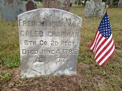
Children

Flowers:


Nearby Cemetories:
1. Rock Creek Cemetery
Meroa, Mitchell County, USA
Coordinate: 43.2352791, -92.9225006
2. West End Cemetery
Meroa, Mitchell County, USA
Coordinate: 43.2216682, -92.9250031
3. Eden Presbyterian Cemetery
Meroa, Mitchell County, USA
Coordinate: 43.2131004, -92.9103012
4. Dudley Cemetery
Dudley (historical), Mitchell County, USA
Coordinate: 43.2252998, -92.8743973
5. Tucker Cemetery
Osage, Mitchell County, USA
Coordinate: 43.2494011, -92.8319016
6. Calvary Cemetery
Osage, Mitchell County, USA
Coordinate: 43.2238998, -92.8300018
7. Oak Grove Cemetery
Mitchell, Mitchell County, USA
Coordinate: 43.3156013, -92.8707962
8. Osage Cemetery
Osage, Mitchell County, USA
Coordinate: 43.2916700, -92.8201700
9. Rudd Evergreen Cemetery
Rudd, Floyd County, USA
Coordinate: 43.1417007, -92.9214020
10. South Osage Mennonite Church Cemetery
Osage, Mitchell County, USA
Coordinate: 43.2544556, -92.7915573
11. Orchard Cemetery
Orchard, Mitchell County, USA
Coordinate: 43.2249985, -92.7838898
12. Spring Grove Cemetery
Nora Springs, Floyd County, USA
Coordinate: 43.1631012, -93.0211029
13. Sacred Heart Cemetery
Osage, Mitchell County, USA
Coordinate: 43.2742004, -92.7917023
14. Saint Johns Lutheran Cemetery
Rock Creek, Mitchell County, USA
Coordinate: 43.3295560, -92.9849770
15. Park Cemetery
Nora Springs, Floyd County, USA
Coordinate: 43.1444016, -92.9982986
16. Riverview Cemetery
Saint Ansgar, Mitchell County, USA
Coordinate: 43.3430328, -92.9220200
17. Saint Johns Lutheran Old Cemetery
Rock Creek, Mitchell County, USA
Coordinate: 43.3313904, -92.9897232
18. Rock Falls Cemetery
Rock Falls, Cerro Gordo County, USA
Coordinate: 43.2122192, -93.0858307
19. Rock Grove Township Cemetery
Nora Springs, Floyd County, USA
Coordinate: 43.1227989, -92.9880981
20. Grafton Cemetery
Grafton, Worth County, USA
Coordinate: 43.3252983, -93.0631027
21. Blakestad Cemetery
Saint Ansgar, Mitchell County, USA
Coordinate: 43.3711014, -92.9400024
22. Immanuel Lutheran Cemetery
Saint Ansgar, Mitchell County, USA
Coordinate: 43.3717003, -92.9257965
23. Emmanuel Lutheran Cemetery
Grafton, Worth County, USA
Coordinate: 43.3300018, -93.0691681
24. Saint Ansgar Cemetery
Saint Ansgar, Mitchell County, USA
Coordinate: 43.3777809, -92.9094391