
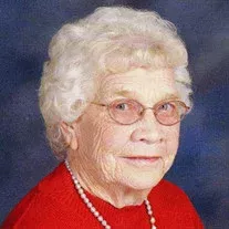
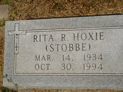
Elizabeth Ann “Betty” Stobbe Grudzinski
| Birth | : | 27 Sep 1931 Ashton, Sherman County, Nebraska, USA |
| Death | : | 1 Feb 2020 Loup City, Sherman County, Nebraska, USA |
| Burial | : | Saint Francis Cemetery, Ashton, Sherman County, USA |
| Coordinate | : | 41.2438000, -98.7994000 |
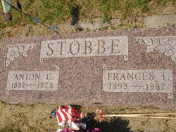
| Description | : | Elizabeth A. “Betty” Grudzinski, 88, of Ashton, died Saturday, Feb. 1, 2020, surrounded by her family, at Rose Lane Home in Loup City. Mass of Christian Burial will be 10:30 a.m. Thursday at St. Josaphat’s Catholic Church in Loup City. The Rev. Richard L. Piontkowski will celebrate the Mass. Private family inurnment will be in the St. Francis Catholic Cemetery in Ashton. A Parish Rosary will be recited 7 p.m. Wednesday at St. Josaphat’s Catholic Church. Betty was born to Anton C. and Frances I. (Badura) Stobbe on Sept. 27, 1931, on a farm southeast of Ashton. |
frequently asked questions (FAQ):
-
Where is Elizabeth Ann “Betty” Stobbe Grudzinski's memorial?
Elizabeth Ann “Betty” Stobbe Grudzinski's memorial is located at: Saint Francis Cemetery, Ashton, Sherman County, USA.
-
When did Elizabeth Ann “Betty” Stobbe Grudzinski death?
Elizabeth Ann “Betty” Stobbe Grudzinski death on 1 Feb 2020 in Loup City, Sherman County, Nebraska, USA
-
Where are the coordinates of the Elizabeth Ann “Betty” Stobbe Grudzinski's memorial?
Latitude: 41.2438000
Longitude: -98.7994000
Family Members:
Parent

Spouse
Siblings

Children
Flowers:


Nearby Cemetories:
1. Saint Francis Cemetery
Ashton, Sherman County, USA
Coordinate: 41.2438000, -98.7994000
2. Union Cemetery
Ashton, Sherman County, USA
Coordinate: 41.2214012, -98.7855988
3. Immanuel Lutheran Cemetery
Ashton, Sherman County, USA
Coordinate: 41.2140000, -98.8142000
4. Mount Carmel Cemetery
Howard County, USA
Coordinate: 41.2797012, -98.7328033
5. Austin Cemetery
Rockville, Sherman County, USA
Coordinate: 41.1880989, -98.8981018
6. Dannevirke Cemetery
Dannevirke, Howard County, USA
Coordinate: 41.3227997, -98.6986008
7. Saint Marys Cemetery
Rockville, Sherman County, USA
Coordinate: 41.1202000, -98.8255000
8. Kelso Cemetery
Howard County, USA
Coordinate: 41.1627998, -98.6707993
9. Danish Lutheran Cemetery
Farwell, Howard County, USA
Coordinate: 41.2134660, -98.6336020
10. Saint Anthony Catholic Cemetery
Farwell, Howard County, USA
Coordinate: 41.1845400, -98.6414700
11. Ebenezer Cemetery
Howard County, USA
Coordinate: 41.1264000, -98.7097015
12. Czechoslovakia Cemetery
Farwell, Howard County, USA
Coordinate: 41.2132988, -98.6224976
13. Scotch Cemetery
Farwell, Howard County, USA
Coordinate: 41.1917000, -98.6130981
14. Evergreen Cemetery
Loup City, Sherman County, USA
Coordinate: 41.2997017, -98.9852982
15. Saint Josaphats Cemetery
Loup City, Sherman County, USA
Coordinate: 41.3022003, -98.9847031
16. Verdurette Cemetery
Sherman County, USA
Coordinate: 41.1697006, -98.9757996
17. Bohemian National Graveyard
Howard County, USA
Coordinate: 41.2492070, -98.5927620
18. Cotesfield Cemetery
Cotesfield, Howard County, USA
Coordinate: 41.3358002, -98.6219025
19. Hayestown Cemetery
Rockville, Sherman County, USA
Coordinate: 41.0766983, -98.8043976
20. Souleville Cemetery
Sherman County, USA
Coordinate: 41.0782080, -98.7553360
21. Zeller Burial Site
Rockville, Sherman County, USA
Coordinate: 41.0725000, -98.8056000
22. Loup Fork Cemetery
Boelus, Howard County, USA
Coordinate: 41.1052600, -98.6631000
23. Saint Josephs Cemetery
Elba, Howard County, USA
Coordinate: 41.2930984, -98.5746994
24. Saint Wenceslaus Cemetery
Howard County, USA
Coordinate: 41.2056007, -98.5702972