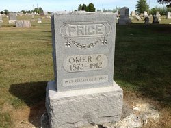
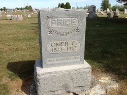
Elizabeth Ellen “Lizzie” Richards Price
| Birth | : | 1 Nov 1872 Hardin County, Ohio, USA |
| Death | : | 25 Jun 1952 Kenton, Hardin County, Ohio, USA |
| Burial | : | Lovelace Baptist Church Cemetery, Greene County, USA |
| Coordinate | : | 36.4009050, -82.6528710 |
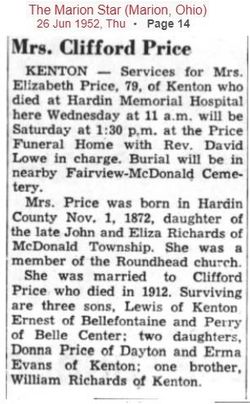
| Description | : | Mrs. Elizabeth Price KENTON - Final rites for Elizabeth Price, 79, of Kenton, who died Wednesday at Hardin Memorial hospital from complications of diseases, will be held at 1:30 p.m. Saturday at Price funeral home. The Rev. David Lowe will officiate and burial will be at Fairview-McDonald cemetery. A native of Hardin-co, she was born Nov. 1, 1872. She was a member of the Roundhead United Brethren church. She was married to Clifford Price, who preceded her in death in 1912. Surviving are three sons, Lewis of Kenton, Ernest of Bellefontaine and Perry of Belle Center; two daughters, Donna Price... Read More |
frequently asked questions (FAQ):
-
Where is Elizabeth Ellen “Lizzie” Richards Price's memorial?
Elizabeth Ellen “Lizzie” Richards Price's memorial is located at: Lovelace Baptist Church Cemetery, Greene County, USA.
-
When did Elizabeth Ellen “Lizzie” Richards Price death?
Elizabeth Ellen “Lizzie” Richards Price death on 25 Jun 1952 in Kenton, Hardin County, Ohio, USA
-
Where are the coordinates of the Elizabeth Ellen “Lizzie” Richards Price's memorial?
Latitude: 36.4009050
Longitude: -82.6528710
Family Members:
Parent
Spouse
Siblings
Children
Flowers:
Nearby Cemetories:
1. Lovelace Baptist Church Cemetery
Greene County, USA
Coordinate: 36.4009050, -82.6528710
2. Chimney Top Free Will Baptist Church Cemetery
Greene County, USA
Coordinate: 36.4034380, -82.6859110
3. Baines Cemetery
Washington County, USA
Coordinate: 36.4105988, -82.6175003
4. Fall Branch First Baptist Church Cemetery
Fall Branch, Washington County, USA
Coordinate: 36.4174995, -82.6213989
5. Fall Branch United Methodist Church Cemetery
Fall Branch, Washington County, USA
Coordinate: 36.4249992, -82.6299973
6. Haws Cemetery
Washington County, USA
Coordinate: 36.3833008, -82.6166992
7. Landon Carter Hale Cemetery
Fall Branch, Washington County, USA
Coordinate: 36.3694700, -82.6242380
8. Church of Christ Cemetery
Fall Branch, Washington County, USA
Coordinate: 36.3998200, -82.6020500
9. Bethany Free Will Baptist Church Cemetery
Jearoldstown, Greene County, USA
Coordinate: 36.3751490, -82.6964110
10. Bethesda Cumberland Presbyterian Church Cemetery
Greene County, USA
Coordinate: 36.3572000, -82.6580000
11. Kincheloe-Hooper Cemetery
Fall Branch, Washington County, USA
Coordinate: 36.3842010, -82.6014023
12. Logans Chapel Cemetery
Fall Branch, Washington County, USA
Coordinate: 36.3903008, -82.5955963
13. Gibson Cemetery
Washington County, USA
Coordinate: 36.4122009, -82.5924988
14. Carr-Whetsel Cemetery
Fall Branch, Sullivan County, USA
Coordinate: 36.4502600, -82.6626300
15. Solomon’s Temple Missionary Baptist Cemetery
Blair Gap, Sullivan County, USA
Coordinate: 36.4506600, -82.6776700
16. Chimney Top Cemetery
Jearoldstown, Greene County, USA
Coordinate: 36.4064429, -82.7196623
17. Crawford Cemetery
Kingsport, Sullivan County, USA
Coordinate: 36.4521640, -82.6780350
18. Light Cemetery
Kingsport, Sullivan County, USA
Coordinate: 36.4496470, -82.6872370
19. Murray Cemetery
Kingsport, Sullivan County, USA
Coordinate: 36.4534960, -82.6797580
20. Mill Creek Baptist Church Cemetery
Fall Branch, Sullivan County, USA
Coordinate: 36.4351220, -82.5951530
21. Steadman Cemetery
Sullivan Gardens, Sullivan County, USA
Coordinate: 36.4277992, -82.5894012
22. Murrell Family Cemetery
Sullivan Gardens, Sullivan County, USA
Coordinate: 36.4557900, -82.6299800
23. Fulkerson Cemetery
Washington County, USA
Coordinate: 36.4117012, -82.5766983
24. Mullins Cemetery
Sullivan Gardens, Sullivan County, USA
Coordinate: 36.4639143, -82.6546705

