
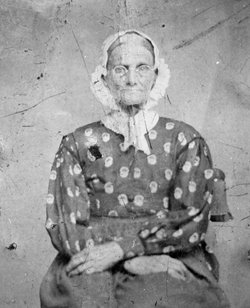

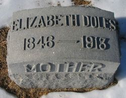
Elizabeth Hobson Doles
| Birth | : | 20 Feb 1846 Ross County, Ohio, USA |
| Death | : | 16 Apr 1913 Medicine Lodge, Barber County, Kansas, USA |
| Burial | : | Omaka Cemetery, Blenheim, Marlborough District, New Zealand |
| Coordinate | : | -41.5381800, 173.9401100 |
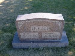
| Description | : | From the Barber County Index (Medicine Lodge, Kansas), April 23, 1913: A GOOD WOMAN GONE Mrs. Elizabeth Doles died at the home of her daughter, Mrs. Ellen Strickland, five miles west of this city, on Wednesday, April 16, 1913, from an attach of heart trouble. She had been afflicted for several years but was critically ill only a short time. The funeral was held at the Doles residence on Thursday afternoon at 2 o'clock, and the remains laid to rest in Highland Cemetery. Elizabeth Hobson was born in Ross County, Ohio, near Chillicothe, February 20, 1846; died near Medicine Lodge, Kansas, April 16,... Read More |
frequently asked questions (FAQ):
-
Where is Elizabeth Hobson Doles's memorial?
Elizabeth Hobson Doles's memorial is located at: Omaka Cemetery, Blenheim, Marlborough District, New Zealand.
-
When did Elizabeth Hobson Doles death?
Elizabeth Hobson Doles death on 16 Apr 1913 in Medicine Lodge, Barber County, Kansas, USA
-
Where are the coordinates of the Elizabeth Hobson Doles's memorial?
Latitude: -41.5381800
Longitude: 173.9401100
Family Members:
Spouse
Children
Flowers:


Nearby Cemetories:
1. Omaka Cemetery
Blenheim, Marlborough District, New Zealand
Coordinate: -41.5381800, 173.9401100
2. Old Renwick Cemetery
Marlborough District, New Zealand
Coordinate: -41.5014030, 173.8909900
3. Fairhall Cemetery
Blenheim, Marlborough District, New Zealand
Coordinate: -41.5294100, 173.8677800
4. Māori Island Urupā Otamawahu
Grovetown, Marlborough District, New Zealand
Coordinate: -41.4729310, 173.9778908
5. Rapaura Anglican Cemetery
Rapaura, Marlborough District, New Zealand
Coordinate: -41.4719700, 173.9014700
6. Rapaura Community Churchyard
Rapaura, Marlborough District, New Zealand
Coordinate: -41.4724800, 173.8995800
7. Pioneers Church Cemetery
Renwick, Marlborough District, New Zealand
Coordinate: -41.5091139, 173.8364765
8. Te Pokohiwi Urupā
Marlborough District, New Zealand
Coordinate: -41.5068950, 174.0612846
9. Wairau Bar Pilot House Graves
Spring Creek, Marlborough District, New Zealand
Coordinate: -41.4970923, 174.0582651
10. Ruakanakana Urupā
Kaituna, Marlborough District, New Zealand
Coordinate: -41.4463616, 173.8779400
11. Upper Wairau Valley Cemetery
Blenheim, Marlborough District, New Zealand
Coordinate: -41.5171130, 173.7974110
12. Wairau Affray Graves
Tuamarina, Marlborough District, New Zealand
Coordinate: -41.4285146, 173.9597007
13. Tuamarina Cemetery
Tuamarina, Marlborough District, New Zealand
Coordinate: -41.4280969, 173.9623665
14. Kaituna Cemetery
Kaituna, Marlborough District, New Zealand
Coordinate: -41.4694650, 173.8036590
15. Maher Family Cemetery
Kaituna, Marlborough District, New Zealand
Coordinate: -41.4682494, 173.7958289
16. Taylor Pass Cemetery
Seddon, Marlborough District, New Zealand
Coordinate: -41.6706624, 173.9871644
17. Seddon Cemetery
Seddon, Marlborough District, New Zealand
Coordinate: -41.6831810, 174.0582210
18. Langley Dale Cemetery
Marlborough District, New Zealand
Coordinate: -41.5076952, 173.7025647
19. Altimarlock Station
Altimarlock, Marlborough District, New Zealand
Coordinate: -41.7387595, 173.8579141
20. Robin Hood Bay Urupā
Marlborough District, New Zealand
Coordinate: -41.3541665, 174.0768701
21. Ocean Bay
Ocean Bay, Marlborough District, New Zealand
Coordinate: -41.3333300, 174.1000000
22. Kakapo Bay Cemetery
Kakapo Bay, Marlborough District, New Zealand
Coordinate: -41.3240576, 174.1040946
23. Whangatoetoe Bay
Marlborough District, New Zealand
Coordinate: -41.3414261, 174.1410659
24. Picton Gaolyard
Picton, Marlborough District, New Zealand
Coordinate: -41.2933357, 174.0046601