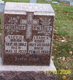
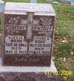
Elizabeth Karen “Lizzie” Tieke Roth
| Birth | : | 18 Sep 1862 Guttenberg, Clayton County, Iowa, USA |
| Death | : | 12 May 1932 Carroll, Carroll County, Iowa, USA |
| Burial | : | Mount Holly Cemetery, Mount Holly, Burlington County, USA |
| Coordinate | : | 40.0014000, -74.7863998 |
| Description | : | Guttenberg Press, Thursday, May 19, 1932, P4, C6 MRS. LIZZIE ROTH - Funeral services for Mrs. Lizzie Roth a former Guttenberg woman were held Monday morning at Carroll, Iowa. She died at her home there Thursday following a lingering illness. She was a daughter of John B. and Maria A. Tieke and was born at Guttenberg on September 18, 1862. On Jan. 24, 1881 she was married to Frank X. Roth, of Templeton, Iowa. They resided on a farm in that community until 20 years ago when they moved to Carroll... Read More |
frequently asked questions (FAQ):
-
Where is Elizabeth Karen “Lizzie” Tieke Roth's memorial?
Elizabeth Karen “Lizzie” Tieke Roth's memorial is located at: Mount Holly Cemetery, Mount Holly, Burlington County, USA.
-
When did Elizabeth Karen “Lizzie” Tieke Roth death?
Elizabeth Karen “Lizzie” Tieke Roth death on 12 May 1932 in Carroll, Carroll County, Iowa, USA
-
Where are the coordinates of the Elizabeth Karen “Lizzie” Tieke Roth's memorial?
Latitude: 40.0014000
Longitude: -74.7863998
Family Members:
Parent
Spouse
Siblings
Children
Flowers:
Nearby Cemetories:
1. Mount Holly Cemetery
Mount Holly, Burlington County, USA
Coordinate: 40.0014000, -74.7863998
2. Mount Holly Friends Cemetery
Mount Holly, Burlington County, USA
Coordinate: 39.9955600, -74.7869800
3. Woodlane Graveyard
Mount Holly, Burlington County, USA
Coordinate: 40.0099983, -74.7901993
4. Saint Andrew's Graveyard
Mount Holly, Burlington County, USA
Coordinate: 39.9878006, -74.7853012
5. Sacred Heart Cemetery
Hainesport, Burlington County, USA
Coordinate: 39.9887630, -74.8069080
6. Timbuctoo Civil War Memorial Cemetery
Westampton, Burlington County, USA
Coordinate: 39.9991000, -74.8126900
7. Brotherhood Cemetery
Hainesport, Burlington County, USA
Coordinate: 39.9880981, -74.8063965
8. Mount Moriah AME Church Cemetery
Hainesport, Burlington County, USA
Coordinate: 39.9878006, -74.8071976
9. Saint Pauls Lutheran Church Garden of Life
Hainesport, Burlington County, USA
Coordinate: 39.9865290, -74.8139710
10. Saint Pauls Lutheran Church Cemetery
Hainesport, Burlington County, USA
Coordinate: 39.9863014, -74.8150024
11. John Skene Gravesite
Burlington County, USA
Coordinate: 40.0371900, -74.8050200
12. Old Lumberton Cemetery
Lumberton, Burlington County, USA
Coordinate: 39.9590988, -74.8058014
13. Saint Martin in the Fields Memorial Garden
Lumberton, Burlington County, USA
Coordinate: 39.9581480, -74.8081230
14. Evergreen Cemetery
Lumberton, Burlington County, USA
Coordinate: 39.9562988, -74.8094025
15. Copany Meeting House Cemetery
Lower Springfield, Burlington County, USA
Coordinate: 40.0481186, -74.7539139
16. Easton Union Cemetery
Hainesport, Burlington County, USA
Coordinate: 39.9658012, -74.8503036
17. Rancocas Quaker Burying Ground
Rancocas, Burlington County, USA
Coordinate: 40.0014000, -74.8705978
18. Vincentown Baptist Cemetery
Vincentown, Burlington County, USA
Coordinate: 39.9395400, -74.7609690
19. Jesus Bread of Life Catholic Cemetery
Mount Laurel, Burlington County, USA
Coordinate: 39.9773600, -74.8673100
20. Old Scott Cemetery #01
Burlington, Burlington County, USA
Coordinate: 40.0608940, -74.8259277
21. Old Scott Cemetery #02
Burlington, Burlington County, USA
Coordinate: 40.0673900, -74.8102530
22. Arneys Mount Friends Burying Ground
Juliustown, Burlington County, USA
Coordinate: 40.0098250, -74.6970240
23. Vincentown Methodist Cemetery
Vincentown, Burlington County, USA
Coordinate: 39.9370900, -74.7488600
24. Vincentown Friends Cemetery
Vincentown, Burlington County, USA
Coordinate: 39.9352400, -74.7495500


