
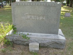
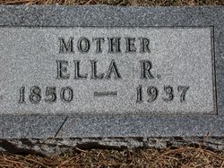
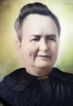
Ella Lucretia Ray Lantz
| Birth | : | 20 May 1850 Findlay, Hancock County, Ohio, USA |
| Death | : | 18 Jun 1937 Wauneta, Chase County, Nebraska, USA |
| Burial | : | Oakland Cemetery, Rome, Floyd County, USA |
| Coordinate | : | 34.2668320, -85.1473550 |
| Plot | : | 23-4SE-3 |
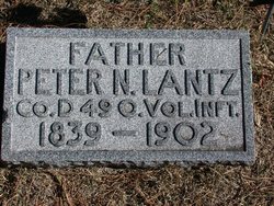
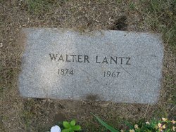
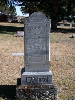
| Description | : | Ella Lucretia Ray was born on May 20, 1850, in Findlay, Ohio. She married Peter Nicholas Lantz in 1872 in Putnam County, Ohio. In 1880 their residence was in Blue Springs, Gage County, Nebraska. In 1900 they were living in Hayes County Nebraska. They had 11 children in 20 years. She died on June 18, 1937, in Wauneta, Nebraska, at the age of 87, and was buried there. Children: Mary May Lantz Hanna (1873 - 1923) Walter J Lantz (1874 - 1967) Gertrude Lantz (1875 - 1937 John Lantz (1880 - 1937) Raymond G Lantz (1880 - 1905) Anna Lantz (1883 - 1945) Marion E. Lantz... Read More |
frequently asked questions (FAQ):
-
Where is Ella Lucretia Ray Lantz's memorial?
Ella Lucretia Ray Lantz's memorial is located at: Oakland Cemetery, Rome, Floyd County, USA.
-
When did Ella Lucretia Ray Lantz death?
Ella Lucretia Ray Lantz death on 18 Jun 1937 in Wauneta, Chase County, Nebraska, USA
-
Where are the coordinates of the Ella Lucretia Ray Lantz's memorial?
Latitude: 34.2668320
Longitude: -85.1473550
Family Members:
Spouse
Children

Flowers:


Nearby Cemetories:
1. Oakland Cemetery
Rome, Floyd County, USA
Coordinate: 34.2668320, -85.1473550
2. East View Cemetery
Rome, Floyd County, USA
Coordinate: 34.2667007, -85.1457977
3. East View Pet Cemetery
Rome, Floyd County, USA
Coordinate: 34.2647990, -85.1449830
4. Sunset Hills Memorial Gardens Cemetery
Rome, Floyd County, USA
Coordinate: 34.2566986, -85.1455994
5. Old County Home Cemetery
Etowah, Floyd County, USA
Coordinate: 34.2643870, -85.1314700
6. Reece Cemetery
Floyd County, USA
Coordinate: 34.2789001, -85.1552963
7. Saint Mary's Garden
Rome, Floyd County, USA
Coordinate: 34.2578730, -85.1638270
8. Crowe Family Cemetery
Rome, Floyd County, USA
Coordinate: 34.2775400, -85.1294400
9. Oak Hill Cemetery
Rome, Floyd County, USA
Coordinate: 34.2592010, -85.1680984
10. Saint Peters Episcopal Church Memorial Garden
Rome, Floyd County, USA
Coordinate: 34.2537490, -85.1704300
11. Saint Peter's Episcopal Church Memorial Garden
Rome, Floyd County, USA
Coordinate: 34.2534700, -85.1704400
12. First Presbyterian Church Memorial Garden
Rome, Floyd County, USA
Coordinate: 34.2528730, -85.1716350
13. John Hume Cemetery
Floyd County, USA
Coordinate: 34.2868996, -85.1228027
14. Myrtle Hill Cemetery
Rome, Floyd County, USA
Coordinate: 34.2518997, -85.1791992
15. Hasty Road Cemetery
Floyd County, USA
Coordinate: 34.2611008, -85.1113968
16. Friendship Baptist Church Cemetery
Rome, Floyd County, USA
Coordinate: 34.2894970, -85.1188620
17. Old Antioch Cemetery
Floyd County, USA
Coordinate: 34.2341995, -85.1530991
18. Rodeph Sholom Cemetery
Rome, Floyd County, USA
Coordinate: 34.2442017, -85.1774979
19. Old Eastview Cemetery
Rome, Floyd County, USA
Coordinate: 34.2341400, -85.1573800
20. Williams Cemetery
Rome, Floyd County, USA
Coordinate: 34.2440700, -85.1083250
21. Morning View Cemetery
Rome, Floyd County, USA
Coordinate: 34.2995990, -85.1203656
22. Berry College Chapel Cemetery
Mount Berry, Floyd County, USA
Coordinate: 34.2860985, -85.1908035
23. Shadyside Cemetery
Rome, Floyd County, USA
Coordinate: 34.2444000, -85.1885986
24. Jones Bend Road Cemetery
Floyd County, USA
Coordinate: 34.3116989, -85.1619034