

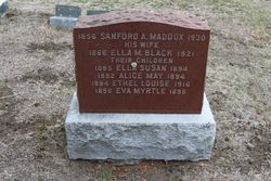
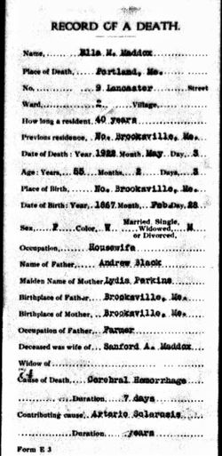
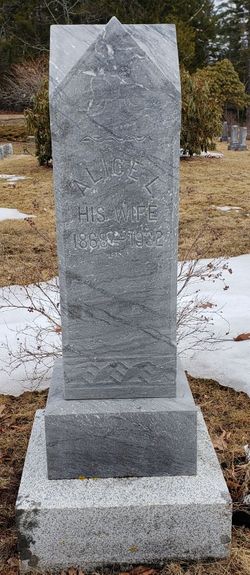
Ella M Black Maddox
| Birth | : | 28 Feb 1866 North Brooksville, Hancock County, Maine, USA |
| Death | : | 3 May 1922 Portland, Cumberland County, Maine, USA |
| Burial | : | Union Cemetery, Weatherly, Carbon County, USA |
| Coordinate | : | 40.9430008, -75.8254013 |
| Description | : | wife of Sanford A. Maddox |
frequently asked questions (FAQ):
-
Where is Ella M Black Maddox's memorial?
Ella M Black Maddox's memorial is located at: Union Cemetery, Weatherly, Carbon County, USA.
-
When did Ella M Black Maddox death?
Ella M Black Maddox death on 3 May 1922 in Portland, Cumberland County, Maine, USA
-
Where are the coordinates of the Ella M Black Maddox's memorial?
Latitude: 40.9430008
Longitude: -75.8254013
Family Members:
Parent
Spouse

Siblings
Children


Flowers:


Nearby Cemetories:
1. Union Cemetery
Weatherly, Carbon County, USA
Coordinate: 40.9430008, -75.8254013
2. Saint Nicholas Cemetery
Weatherly, Carbon County, USA
Coordinate: 40.9433363, -75.8361885
3. Saints Cyril and Methodius Postupack Cemetery
Weatherly, Carbon County, USA
Coordinate: 40.9290600, -75.8467700
4. Saint Joseph's Roman Catholic Church Cemetery
Weatherly, Carbon County, USA
Coordinate: 40.9780000, -75.7741000
5. Eckley Cemetery
Eckley, Luzerne County, USA
Coordinate: 40.9888820, -75.8630500
6. Methodist Episcopal Cemetery
Carbon County, USA
Coordinate: 40.9721000, -75.7595000
7. Maple Grove Cemetery
Beaver Meadows, Carbon County, USA
Coordinate: 40.9300880, -75.9075180
8. Old Reed Cemetery
Beaver Meadows, Carbon County, USA
Coordinate: 40.9000850, -75.8879760
9. Beaver Meadows Cemetery
Beaver Meadows, Carbon County, USA
Coordinate: 40.9286000, -75.9172000
10. Gates of Heaven Cemetery
Nesquehoning, Carbon County, USA
Coordinate: 40.8708000, -75.8099976
11. Laurytown Road Cemetery
Weatherly, Carbon County, USA
Coordinate: 40.9857300, -75.7460760
12. Saints Peter and Paul Byzantine Catholic Cemetery
Beaver Meadows, Carbon County, USA
Coordinate: 40.9344000, -75.9255000
13. Saint Mary's Roman Catholic Cemetery
Beaver Meadows, Carbon County, USA
Coordinate: 40.9348240, -75.9259990
14. Packer Cemetery
Weatherly, Carbon County, USA
Coordinate: 40.9009000, -75.9136000
15. Saint Mary's Byzantine Catholic Church Cemetery
Nesquehoning, Carbon County, USA
Coordinate: 40.8688370, -75.7879370
16. Sacred Heart Cemetery
Nesquehoning, Carbon County, USA
Coordinate: 40.8651190, -75.8040360
17. Protestant Cemetery
Nesquehoning, Carbon County, USA
Coordinate: 40.8649000, -75.8052000
18. Saints Cyril and Methodius Parish Cemetery
Nesquehoning, Carbon County, USA
Coordinate: 40.8693000, -75.7832000
19. Saint Johns Orthodox Cemetery
Nesquehoning, Carbon County, USA
Coordinate: 40.8698000, -75.7798000
20. Stockton Mine Disaster Cemetery
Hazleton, Luzerne County, USA
Coordinate: 40.9596640, -75.9325540
21. Saint James Episcopal Churchyard
Drifton, Luzerne County, USA
Coordinate: 41.0014880, -75.9062660
22. Evergreen Cemetery
Jim Thorpe, Carbon County, USA
Coordinate: 40.8800011, -75.7391968
23. Saint Ann's Parish Cemetery
Freeland, Luzerne County, USA
Coordinate: 41.0097008, -75.9067001
24. Immaculate Conception Cemetery
Jim Thorpe, Carbon County, USA
Coordinate: 40.8767014, -75.7427979