
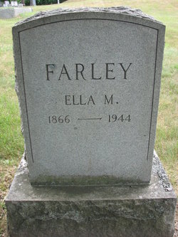
Ella Maria Farley Farley
| Birth | : | 28 Feb 1866 Hollis, Hillsborough County, New Hampshire, USA |
| Death | : | 4 Nov 1944 Melrose, Middlesex County, Massachusetts, USA |
| Burial | : | St. Michael's Burial Ground, Bath, Bath and North East Somerset Unitary Authority, England |
| Coordinate | : | 51.3838810, -2.3594090 |
| Description | : | Ella was a Hollis High School Graduate in 1884. She resided in West Townsend Massachusetts after graduation. She may have had children. Ella's death record gives her death age as 78 years 8 months 7 days. That calculates to February 28, 1866. Ella was a servant for John and Mary Colburn in Hollis in 1910 and 1920 censuses. In 1930 she lived in Townsend. Her very short marriage was the first for both of them. I didn't find any children. -------------------------------------------- New Hampshire, Death and Burial Records Index, 1654-1949: Name: Ella Maria Farley... Read More |
frequently asked questions (FAQ):
-
Where is Ella Maria Farley Farley's memorial?
Ella Maria Farley Farley's memorial is located at: St. Michael's Burial Ground, Bath, Bath and North East Somerset Unitary Authority, England.
-
When did Ella Maria Farley Farley death?
Ella Maria Farley Farley death on 4 Nov 1944 in Melrose, Middlesex County, Massachusetts, USA
-
Where are the coordinates of the Ella Maria Farley Farley's memorial?
Latitude: 51.3838810
Longitude: -2.3594090
Family Members:
Parent
Spouse
Siblings

Flowers:


Nearby Cemetories:
1. St. Michael's Burial Ground
Bath, Bath and North East Somerset Unitary Authority, England
Coordinate: 51.3838810, -2.3594090
2. Ss Michael & Paul Churchyard
Bath, Bath and North East Somerset Unitary Authority, England
Coordinate: 51.3834970, -2.3596980
3. Quaker Meeting House
Bath, Bath and North East Somerset Unitary Authority, England
Coordinate: 51.3823280, -2.3604380
4. Bath General Hospital Burial Ground
Bath and North East Somerset Unitary Authority, England
Coordinate: 51.3824715, -2.3614742
5. Bath Abbey
Bath, Bath and North East Somerset Unitary Authority, England
Coordinate: 51.3815310, -2.3586640
6. St. Mary de Stall Churchyard (Defunct)
Bath, Bath and North East Somerset Unitary Authority, England
Coordinate: 51.3813350, -2.3600353
7. St Mary's Chapel, Queens Square
Bath, Bath and North East Somerset Unitary Authority, England
Coordinate: 51.3827790, -2.3649790
8. Old Orchard Street Catholic Burial Vault
Bath, Bath and North East Somerset Unitary Authority, England
Coordinate: 51.3800370, -2.3579910
9. St James Old Burial Ground
Bath, Bath and North East Somerset Unitary Authority, England
Coordinate: 51.3798600, -2.3610100
10. St. Swithin Churchyard
Bath, Bath and North East Somerset Unitary Authority, England
Coordinate: 51.3885480, -2.3594500
11. St. Mary's Churchyard
Bathwick, Bath and North East Somerset Unitary Authority, England
Coordinate: 51.3876120, -2.3543540
12. St. John the Baptist Churchyard
Bathwick, Bath and North East Somerset Unitary Authority, England
Coordinate: 51.3886890, -2.3547030
13. Walcot Methodist Chapel Burial Ground
Bath, Bath and North East Somerset Unitary Authority, England
Coordinate: 51.3897080, -2.3579610
14. Saint Mark's Churchyard
Widcombe, Bath and North East Somerset Unitary Authority, England
Coordinate: 51.3766660, -2.3588010
15. Baptist Burial Ground
Widcombe, Bath and North East Somerset Unitary Authority, England
Coordinate: 51.3764216, -2.3556947
16. St Mary Magdalen Chapel
Widcombe, Bath and North East Somerset Unitary Authority, England
Coordinate: 51.3760486, -2.3643405
17. St. James' Cemetery
Bath, Bath and North East Somerset Unitary Authority, England
Coordinate: 51.3802000, -2.3722200
18. Old Baptist Burial Ground
Walcot, Bath and North East Somerset Unitary Authority, England
Coordinate: 51.3755070, -2.3544360
19. Abbey & St James' Graveyard for the Poor
Widcombe, Bath and North East Somerset Unitary Authority, England
Coordinate: 51.3753550, -2.3545640
20. Independent Burial Ground Argyle Chapel
Bath, Bath and North East Somerset Unitary Authority, England
Coordinate: 51.3925420, -2.3536920
21. Quaker Burial Ground
Widcombe, Bath and North East Somerset Unitary Authority, England
Coordinate: 51.3744350, -2.3498460
22. Smallcombe Vale Cemetery
Bathwick, Bath and North East Somerset Unitary Authority, England
Coordinate: 51.3757400, -2.3429400
23. St Thomas à Becket's Church
Widcombe, Bath and North East Somerset Unitary Authority, England
Coordinate: 51.3734250, -2.3465560
24. St. Mary The Virgin Churchyard
Bathwick, Bath and North East Somerset Unitary Authority, England
Coordinate: 51.3759930, -2.3411930