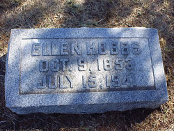
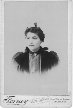
Ellen Chase Hobbs
| Birth | : | 9 Oct 1853 Long Grove, Scott County, Iowa, USA |
| Death | : | 15 Jul 1941 Solomon, Dickinson County, Kansas, USA |
| Burial | : | Prairie Mound Cemetery, Solomon, Dickinson County, USA |
| Coordinate | : | 38.9193993, -97.3527985 |
| Description | : | Daughter of Josephus Palmer Chase (born 1819 in OH or NY) & Irena Laurence Harmon (born 1817 in OH). Ellen was born in Long Grove, IA on October 9, 1853, the 5th of six children. The family moved, by wagon and ox team, to Humboldt Creek in Davis (Geary) county, Kansas in June of 1857. Later her father and eldest brother, George, went to Cripple Creek, CO., in search of gold. While there her father died from an attack of mountain fever and was buried in a miners grave at the foot of Pike's Peak in 1861. |
frequently asked questions (FAQ):
-
Where is Ellen Chase Hobbs's memorial?
Ellen Chase Hobbs's memorial is located at: Prairie Mound Cemetery, Solomon, Dickinson County, USA.
-
When did Ellen Chase Hobbs death?
Ellen Chase Hobbs death on 15 Jul 1941 in Solomon, Dickinson County, Kansas, USA
-
Where are the coordinates of the Ellen Chase Hobbs's memorial?
Latitude: 38.9193993
Longitude: -97.3527985
Family Members:
Parent
Spouse
Siblings
Children
Flowers:
Nearby Cemetories:
1. Prairie Mound Cemetery
Solomon, Dickinson County, USA
Coordinate: 38.9193993, -97.3527985
2. Mount Calvary Cemetery
Saline County, USA
Coordinate: 38.9247017, -97.3891983
3. Roggendorf Family Cemetery
New Cambria, Saline County, USA
Coordinate: 38.8803940, -97.3926160
4. Lemcke Cemetery
New Cambria, Saline County, USA
Coordinate: 38.8770730, -97.4022430
5. McReynolds Gravesite
Saline County, USA
Coordinate: 38.8520900, -97.4260900
6. Abilene Cemetery
Abilene, Dickinson County, USA
Coordinate: 38.9322014, -97.2217026
7. Mount Saint Joseph Cemetery
Abilene, Dickinson County, USA
Coordinate: 38.9442170, -97.2218690
8. Greenville Cemetery
Niles, Ottawa County, USA
Coordinate: 38.9794006, -97.4646988
9. Heart Land Prairie Cemetery
Niles, Ottawa County, USA
Coordinate: 38.9693700, -97.4732900
10. Dwight D. Eisenhower Municipal Building
Abilene, Dickinson County, USA
Coordinate: 38.9191100, -97.2155700
11. Saint John's Episcopal Church Memorial Garden
Abilene, Dickinson County, USA
Coordinate: 38.9202700, -97.2137300
12. Eisenhower Presidential Library and Museum Chapel
Abilene, Dickinson County, USA
Coordinate: 38.9118450, -97.2129410
13. Donmyer Cemetery
New Cambria, Saline County, USA
Coordinate: 38.8707500, -97.4861800
14. Poheta Cemetery
Kipp, Saline County, USA
Coordinate: 38.7980600, -97.3993300
15. Brown Memorial Cemetery
Abilene, Dickinson County, USA
Coordinate: 38.8755950, -97.1993410
16. Highland Cemetery
New Cambria, Saline County, USA
Coordinate: 38.9103012, -97.5199966
17. Green Lawn Cemetery
Holland, Dickinson County, USA
Coordinate: 38.7910995, -97.3158035
18. Sanborn Cemetery
New Cambria, Saline County, USA
Coordinate: 38.8510500, -97.5019400
19. Newbern Cemetery
Holland, Dickinson County, USA
Coordinate: 38.8133011, -97.2427979
20. Farmington Cemetery
Abilene, Dickinson County, USA
Coordinate: 38.8707800, -97.1860200
21. Harmony Cemetery
Holland, Dickinson County, USA
Coordinate: 38.7985430, -97.2632760
22. Prairiedale Cemetery
Talmage, Dickinson County, USA
Coordinate: 39.0471992, -97.2652969
23. White Cloud Cemetery
Manchester, Dickinson County, USA
Coordinate: 39.0744019, -97.3525009
24. Zion Cemetery
Abilene, Dickinson County, USA
Coordinate: 39.0319240, -97.2045850

