


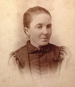
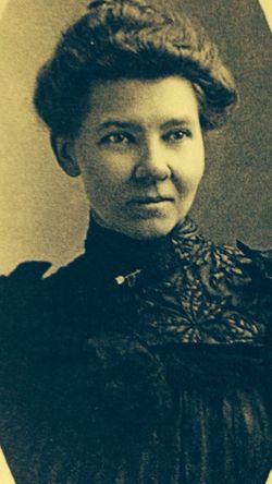
Ellen Columbia “Nellie” Rogers Roberts
| Birth | : | 3 Jun 1845 Pleasant Lake, Jackson County, Michigan, USA |
| Death | : | 18 Aug 1908 Dunlap, Harrison County, Iowa, USA |
| Burial | : | All Saints Cemetery, Jensen Beach, Martin County, USA |
| Coordinate | : | 27.2315559, -80.2202835 |
| Plot | : | Block 14 Row 11 |
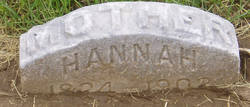
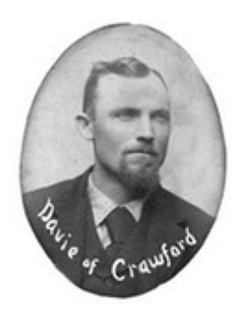
| Description | : | Ellen or 'Nellie' (as she was referred to by my family), was the daughter of Jonathan Rogers and Hannah Hoskins. Jonathan Rogers was 54 years old when he married 18 year old Hannah Hoskins (marriage records shows her maiden name as HARKINS) on April 30, 1842 in Jackson Co., Michigan. Jonathan Rogers evidently passed away after his enumeration in the 1850 U.S. Census dated August 23, 1850 and before the marriage of his wife, Hannah, to John Turner Davie. I am unable to locate their marriage record, but their first child was born in December... Read More |
frequently asked questions (FAQ):
-
Where is Ellen Columbia “Nellie” Rogers Roberts's memorial?
Ellen Columbia “Nellie” Rogers Roberts's memorial is located at: All Saints Cemetery, Jensen Beach, Martin County, USA.
-
When did Ellen Columbia “Nellie” Rogers Roberts death?
Ellen Columbia “Nellie” Rogers Roberts death on 18 Aug 1908 in Dunlap, Harrison County, Iowa, USA
-
Where are the coordinates of the Ellen Columbia “Nellie” Rogers Roberts's memorial?
Latitude: 27.2315559
Longitude: -80.2202835
Family Members:
Parent
Spouse
Siblings

Children
Flowers:


Nearby Cemetories:
1. All Saints Cemetery
Jensen Beach, Martin County, USA
Coordinate: 27.2315559, -80.2202835
2. Trinity United Methodist Church Memorial Garden
Jensen Beach, Martin County, USA
Coordinate: 27.2319880, -80.2357230
3. Washington Memorial Cemetery
Jensen Beach, Martin County, USA
Coordinate: 27.2496903, -80.2376692
4. Saint Marys Memorial Garden
Stuart, Martin County, USA
Coordinate: 27.1981930, -80.2424860
5. Possum Long House Memory Lane Garden
Stuart, Martin County, USA
Coordinate: 27.1940680, -80.2359490
6. First Presbyterian Church Memorial Garden
Stuart, Martin County, USA
Coordinate: 27.2258350, -80.2744370
7. Fernhill Memorial Gardens and Mausoleum
Stuart, Martin County, USA
Coordinate: 27.1851692, -80.2516556
8. Eden Cemetery
Eden, St. Lucie County, USA
Coordinate: 27.2809616, -80.2457197
9. Moores Cemetery
Stuart, Martin County, USA
Coordinate: 27.1764000, -80.2513240
10. Stuart Congregational Church Columbarium
Stuart, Martin County, USA
Coordinate: 27.1676740, -80.2375870
11. Forest Hills Memorial Park and Mausoleum
Palm City, Martin County, USA
Coordinate: 27.1883221, -80.2837753
12. Immanuel Lutheran Church Gardens
Palm City, Martin County, USA
Coordinate: 27.1726830, -80.2709630
13. First Congregational Church Memorial Garden
Port Saint Lucie, St. Lucie County, USA
Coordinate: 27.2707950, -80.3034550
14. Saint Lukes Episcopal Church Cemetery
Port Salerno, Martin County, USA
Coordinate: 27.1412688, -80.1924654
15. Peace Presbyterian Church Memorial Garden
Stuart, Martin County, USA
Coordinate: 27.1423600, -80.1872900
16. Palm City Presbyterian Church Columbarium
Palm City, Martin County, USA
Coordinate: 27.1609730, -80.2905230
17. Pine Rest Cemetery
Port Salerno, Martin County, USA
Coordinate: 27.1384800, -80.1955700
18. New Monrovia Cemetery
Port Salerno, Martin County, USA
Coordinate: 27.1376190, -80.1967730
19. Spruce Bluff Cemetery
Port Saint Lucie, St. Lucie County, USA
Coordinate: 27.2589550, -80.3327380
20. Mariner Sands Gardens
Stuart, Martin County, USA
Coordinate: 27.1261480, -80.1762170
21. Ashley Family Cemetery
Stuart, Martin County, USA
Coordinate: 27.1253160, -80.1763070
22. Episcopal Church of the Advent Memorial Garden
Palm City, Martin County, USA
Coordinate: 27.1509640, -80.3191460
23. Palms Cemetery
Ankona, St. Lucie County, USA
Coordinate: 27.3562306, -80.2831417
24. Holy Faith Episcopal Church Gardens
Port Saint Lucie, St. Lucie County, USA
Coordinate: 27.3381120, -80.3248980