
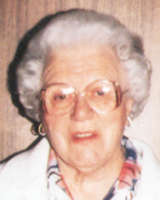
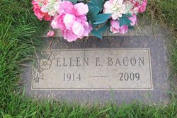
Ellen E. Christianson Bacon
| Birth | : | 11 Apr 1914 Black Eagle, Cascade County, Montana, USA |
| Death | : | 13 May 2009 Great Falls, Cascade County, Montana, USA |
| Burial | : | Hillcrest Cemetery, Rocky Ford, Otero County, USA |
| Coordinate | : | 38.0388985, -103.7071991 |
| Description | : | Great Falls Tribune Ellen E. (Christianson) Bacon, 95, of Great Falls, a homemaker, died of natural causes Wednesday at a local hospital. Visitation is 5 to 7 p.m. Sunday at O'Connor Funeral Home. Funeral Liturgy is 2 p.m. Monday at Our Lady of Lourdes Catholic Church, with burial in Mount Olivet Cemetery. Survivors include a daughter-in-law, Pat Smith of Black Eagle; sister-in-law Mary Ellen Christianson of Great Falls; four grandchildren, Michael J. Bacon and Camie (Mike) Zufelt of Helena, Douglas S. Bacon of Sheridan, Ore., and David (Cora) Bacon of Great Falls; 12 great-grandchildren; four great-great-grandchildren; and several nieces and nephews. Ellen was born... Read More |
frequently asked questions (FAQ):
-
Where is Ellen E. Christianson Bacon's memorial?
Ellen E. Christianson Bacon's memorial is located at: Hillcrest Cemetery, Rocky Ford, Otero County, USA.
-
When did Ellen E. Christianson Bacon death?
Ellen E. Christianson Bacon death on 13 May 2009 in Great Falls, Cascade County, Montana, USA
-
Where are the coordinates of the Ellen E. Christianson Bacon's memorial?
Latitude: 38.0388985
Longitude: -103.7071991
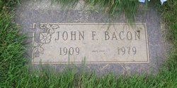
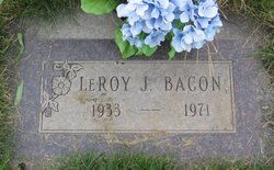
Family Members:
Spouse
Children
Flowers:


Nearby Cemetories:
1. Hillcrest Cemetery
Rocky Ford, Otero County, USA
Coordinate: 38.0388985, -103.7071991
2. Valley View Cemetery
Rocky Ford, Otero County, USA
Coordinate: 38.0388985, -103.7093964
3. Ormega Cemetery
La Junta, Otero County, USA
Coordinate: 37.9684000, -103.5770000
4. Fairview Cemetery
La Junta, Otero County, USA
Coordinate: 37.9873000, -103.5607000
5. Calvary Cemetery
La Junta, Otero County, USA
Coordinate: 37.9832000, -103.5622000
6. Holbrook Cemetery
Otero County, USA
Coordinate: 38.0842018, -103.5432968
7. Saint Andrews Episcopal Church Columbarium
La Junta, Otero County, USA
Coordinate: 37.9809000, -103.5455000
8. Manzanola Mountainview Cemetery
Manzanola, Otero County, USA
Coordinate: 38.0900002, -103.8764038
9. Lakeview Cemetery
Sugar City, Crowley County, USA
Coordinate: 38.2332993, -103.6725006
10. East Holbrook Mennonite Cemetery
Cheraw, Otero County, USA
Coordinate: 38.1101837, -103.4729767
11. Saint Paul’s Lutheran Cemetery
Otero County, USA
Coordinate: 38.0342000, -103.4542000
12. Olney Springs Cemetery
Olney Springs, Crowley County, USA
Coordinate: 38.1472282, -103.9310684
13. Valley View Cemetery
Ordway, Crowley County, USA
Coordinate: 38.2546997, -103.7489014
14. Bents Old Fort Cemetery
La Junta, Otero County, USA
Coordinate: 38.0416000, -103.4297000
15. Barnard Burial Site
Elder, Otero County, USA
Coordinate: 38.1235554, -103.9665095
16. Timpas Cemetery
Timpas, Otero County, USA
Coordinate: 37.8081000, -103.7681000
17. Fowler Cemetery
Fowler, Otero County, USA
Coordinate: 38.1301000, -104.0076000
18. Higbee Cemetery
Higbee, Otero County, USA
Coordinate: 37.7630997, -103.4555969
19. Martinez Cemetery
Otero County, USA
Coordinate: 37.7303009, -103.5002975
20. Nepesta Cemetery
Nepesta, Pueblo County, USA
Coordinate: 38.1672000, -104.1436000
21. Lucero Family Cemetery
Nepesta, Pueblo County, USA
Coordinate: 38.1677340, -104.1480540
22. Las Animas Cemetery
Las Animas, Bent County, USA
Coordinate: 38.0424995, -103.2174988
23. Boggsville National Historic Site Grounds
Boggsville, Bent County, USA
Coordinate: 38.0425130, -103.2102730
24. Arlington Cemetery
Arlington, Kiowa County, USA
Coordinate: 38.3232994, -103.3597031