
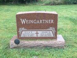
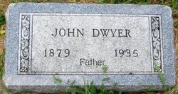
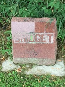
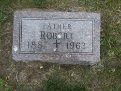
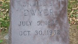
Ellen Frances “Ella” Dwyer Weingartner
| Birth | : | 20 Sep 1889 Clay County, South Dakota, USA |
| Death | : | 8 May 1966 |
| Burial | : | Rainsough Jewish Cemetery, Prestwich, Metropolitan Borough of Bury, England |
| Coordinate | : | 53.5185530, -2.2906950 |
frequently asked questions (FAQ):
-
Where is Ellen Frances “Ella” Dwyer Weingartner's memorial?
Ellen Frances “Ella” Dwyer Weingartner's memorial is located at: Rainsough Jewish Cemetery, Prestwich, Metropolitan Borough of Bury, England.
-
When did Ellen Frances “Ella” Dwyer Weingartner death?
Ellen Frances “Ella” Dwyer Weingartner death on 8 May 1966 in
-
Where are the coordinates of the Ellen Frances “Ella” Dwyer Weingartner's memorial?
Latitude: 53.5185530
Longitude: -2.2906950
Family Members:
Parent
Spouse
Siblings

Children

Flowers:


Nearby Cemetories:
1. Rainsough Jewish Cemetery
Prestwich, Metropolitan Borough of Bury, England
Coordinate: 53.5185530, -2.2906950
2. Agecroft Jewish Cemetery
Pendlebury, Metropolitan Borough of Salford, England
Coordinate: 53.5110302, -2.2955830
3. Agecroft Cemetery and Crematorium
Salford, Metropolitan Borough of Salford, England
Coordinate: 53.5100250, -2.2940500
4. St. Mary the Virgin Churchyard
Prestwich, Metropolitan Borough of Bury, England
Coordinate: 53.5294033, -2.2864891
5. St Paul's Churchyard
Salford, Metropolitan Borough of Salford, England
Coordinate: 53.5148800, -2.2725500
6. Great Synagogue Cemetery
Prestwich, Metropolitan Borough of Bury, England
Coordinate: 53.5315510, -2.2845730
7. St John The Evangelist Churchyard
Pendlebury, Metropolitan Borough of Salford, England
Coordinate: 53.5036200, -2.3088500
8. Saint Augustine's Churchyard
Pendlebury, Metropolitan Borough of Salford, England
Coordinate: 53.5107070, -2.3223960
9. Manchester Reform Jewish Old Cemetery
Whitefield, Metropolitan Borough of Bury, England
Coordinate: 53.5442728, -2.2918894
10. St. Thomas' Churchyard
Salford, Metropolitan Borough of Salford, England
Coordinate: 53.4921430, -2.2856130
11. St. Marks' Churchyard
Cheetham Hill, Metropolitan Borough of Manchester, England
Coordinate: 53.5113780, -2.2462660
12. Wesleyan Methodist Cemetery
Crumpsall, Metropolitan Borough of Manchester, England
Coordinate: 53.5142870, -2.2447610
13. St. Paul's Wesleyan Methodist Churchyard
Swinton, Metropolitan Borough of Salford, England
Coordinate: 53.5133900, -2.3397500
14. St Anne Churchyard
Clifton, Metropolitan Borough of Salford, England
Coordinate: 53.5277070, -2.3391650
15. St. Peter's Churchyard
Swinton, Metropolitan Borough of Salford, England
Coordinate: 53.5119130, -2.3413860
16. All Saints Churchyard Stand
Whitefield, Metropolitan Borough of Bury, England
Coordinate: 53.5501180, -2.2985570
17. Swinton Cemetery
Swinton, Metropolitan Borough of Salford, England
Coordinate: 53.5183372, -2.3457739
18. Blackley Cemetery and Crematorium
Blackley, Metropolitan Borough of Manchester, England
Coordinate: 53.5333176, -2.2394190
19. Stand United Reformed Church Burial Ground
Radcliffe, Metropolitan Borough of Bury, England
Coordinate: 53.5512300, -2.3140600
20. St Luke's Churchyard
Cheetham Hill, Metropolitan Borough of Manchester, England
Coordinate: 53.5041660, -2.2354680
21. Strangeways Prison Cemetery (Defunct)
Manchester, Metropolitan Borough of Manchester, England
Coordinate: 53.4925000, -2.2463890
22. Crumpsall Jewish Cemetery
Crumpsall, Metropolitan Borough of Manchester, England
Coordinate: 53.5124250, -2.2280270
23. New Jerusalem Church Burial
Radcliffe, Metropolitan Borough of Bury, England
Coordinate: 53.5542680, -2.3174070
24. Blackley Presbyterian Chapel Chapelyard
Blackley, Metropolitan Borough of Manchester, England
Coordinate: 53.5233100, -2.2248110