
| Birth | : | 26 Mar 1847 Jasper County, Iowa, USA |
| Death | : | 8 Mar 1932 French Camp, San Joaquin County, California, USA |
| Burial | : | Stockton Rural Cemetery, Stockton, San Joaquin County, USA |
| Coordinate | : | 37.9794006, -121.2869034 |
| Plot | : | Block 7A, Grave 650 |
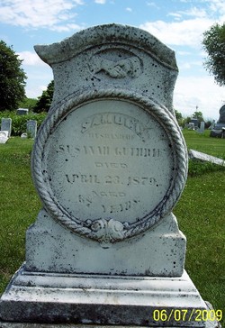
| Description | : | Per her death certificate, Ellen Custer died on 8 Mar 1932 at the San Joaquin County Hospital in French Camp, San Joaquin County, CA. She entered the hospital on 6 Mar 1932 and she was treated by the hospital staff until her death two days later. One of the staff treating her was Dr. William Friedberger. He determined Mrs. Custer died from "Valvular Heart Disease." She was thereafter buried in the Stockton Rural Cemetery without a grave marker on 10 Mar 1932, with the firm of B. C. Wallace of Stockton taking care of the funeral... Read More |
frequently asked questions (FAQ):
-
Where is Ellen Nancy Guthrie Custer's memorial?
Ellen Nancy Guthrie Custer's memorial is located at: Stockton Rural Cemetery, Stockton, San Joaquin County, USA.
-
When did Ellen Nancy Guthrie Custer death?
Ellen Nancy Guthrie Custer death on 8 Mar 1932 in French Camp, San Joaquin County, California, USA
-
Where are the coordinates of the Ellen Nancy Guthrie Custer's memorial?
Latitude: 37.9794006
Longitude: -121.2869034
Family Members:
Parent
Spouse

Siblings
Children
Flowers:


Nearby Cemetories:
1. Stockton Rural Cemetery
Stockton, San Joaquin County, USA
Coordinate: 37.9794006, -121.2869034
2. Stockton Woodland Mausoleum
Stockton, San Joaquin County, USA
Coordinate: 37.9762400, -121.2878000
3. Casa Bonita Mausoleum
Stockton, San Joaquin County, USA
Coordinate: 37.9752340, -121.2877800
4. San Joaquin Catholic Cemetery
Stockton, San Joaquin County, USA
Coordinate: 37.9707830, -121.2850190
5. Stockton State Hospital Cemetery
Stockton, San Joaquin County, USA
Coordinate: 37.9663110, -121.2846850
6. Temple Israel Cemetery
Stockton, San Joaquin County, USA
Coordinate: 37.9640541, -121.2784348
7. Central United Methodist Church Columbarium
Stockton, San Joaquin County, USA
Coordinate: 37.9825710, -121.3078170
8. Thomas Lindsay Gravesite
San Joaquin County, USA
Coordinate: 37.9573110, -121.2918430
9. David Kelsey Gravesite
Stockton, San Joaquin County, USA
Coordinate: 37.9573110, -121.2918430
10. Citizens Cemetery
Stockton, San Joaquin County, USA
Coordinate: 37.9559410, -121.2769120
11. Chinese Cemetery
French Camp, San Joaquin County, USA
Coordinate: 37.8819962, -121.2805862
12. Congregation Adas Yeshuran of Stockton Cemetery
French Camp, San Joaquin County, USA
Coordinate: 37.8784065, -121.2740784
13. Congregation of Ahavas Achim Cemetery
French Camp, San Joaquin County, USA
Coordinate: 37.8778419, -121.2753067
14. Live Oak Cemetery
Lodi, San Joaquin County, USA
Coordinate: 38.0868760, -121.2874780
15. Cherokee Memorial Park
Lodi, San Joaquin County, USA
Coordinate: 38.1017303, -121.2585983
16. Park View Cemetery
Manteca, San Joaquin County, USA
Coordinate: 37.8617249, -121.2238312
17. Islamic Cemetery of California
Lodi, San Joaquin County, USA
Coordinate: 38.1091730, -121.2563590
18. Collegeville Cemetery
Collegeville, San Joaquin County, USA
Coordinate: 37.9044800, -121.1466141
19. Saint John The Baptist Episcopal Columbarium
Lodi, San Joaquin County, USA
Coordinate: 38.1213500, -121.3074400
20. Lodi Memorial Park and Cemetery
Lodi, San Joaquin County, USA
Coordinate: 38.1319008, -121.2455978
21. Linden Cemetery
Linden, San Joaquin County, USA
Coordinate: 38.0226707, -121.0889053
22. Woodbridge Masonic Cemetery
Woodbridge, San Joaquin County, USA
Coordinate: 38.1496506, -121.3016663
23. East Union Cemetery
Manteca, San Joaquin County, USA
Coordinate: 37.8114014, -121.2350006
24. Harmony Grove Cemetery
Lockeford, San Joaquin County, USA
Coordinate: 38.1478004, -121.1755981