
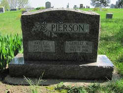
| Birth | : | Oct 1875 Sidney, Fremont County, Iowa, USA |
| Death | : | 1958 Sidney, Fremont County, Iowa, USA |
| Burial | : | Casterton Old Cemetery, Casterton, Glenelg Shire, Australia |
| Coordinate | : | -37.5948850, 141.3700380 |
| Plot | : | Section 2 Row 8 |
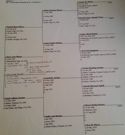
| Description | : | Elmira "Mida" Jordan was the daughter of Martha Elmira Henderson and John William Jordan. She married Ernest Warren Pierson, son of James Knox Pierson and Ava McBee, on 29 Oct 1899 at Hamburg. Ernest and Mida had the following known children: Bryce Cecil, Gladys Fern (Liggett), Iona P (Franks), Ada Mae (Keyser), Eva Mildred, Wanda Irene, and Opal F (Franks). Ernest was a farmer, drove a school bus, and served as city marshall for Sidney, Iowa until he became ill. He died in 1954 at the age of 79 years. Mida died in 1958. |
frequently asked questions (FAQ):
-
Where is Elmira Ellen “Mida” Jordan Pierson's memorial?
Elmira Ellen “Mida” Jordan Pierson's memorial is located at: Casterton Old Cemetery, Casterton, Glenelg Shire, Australia.
-
When did Elmira Ellen “Mida” Jordan Pierson death?
Elmira Ellen “Mida” Jordan Pierson death on 1958 in Sidney, Fremont County, Iowa, USA
-
Where are the coordinates of the Elmira Ellen “Mida” Jordan Pierson's memorial?
Latitude: -37.5948850
Longitude: 141.3700380
Family Members:
Parent

Spouse
Siblings
Children
Flowers:


Nearby Cemetories:
1. Casterton Old Cemetery
Casterton, Glenelg Shire, Australia
Coordinate: -37.5948850, 141.3700380
2. Casterton Cemetery
Casterton, Glenelg Shire, Australia
Coordinate: -37.5992440, 141.4088270
3. Sandford Cemetery
Sandford, Glenelg Shire, Australia
Coordinate: -37.6290998, 141.4562576
4. Merino Cemetery
Merino, Glenelg Shire, Australia
Coordinate: -37.6908180, 141.5434050
5. Heathfield Cemetery
Lake Mundi, Glenelg Shire, Australia
Coordinate: -37.5713233, 141.1436213
6. Strathdownie Cemetery
Strathdownie, Glenelg Shire, Australia
Coordinate: -37.7174000, 141.1676280
7. Rifle Ranges Pastoral Run
Digby, Glenelg Shire, Australia
Coordinate: -37.7813184, 141.5104222
8. Coleraine Cemetery
Coleraine, Southern Grampians Shire, Australia
Coordinate: -37.5974900, 141.6631400
9. Digby Cemetery
Digby, Glenelg Shire, Australia
Coordinate: -37.8196840, 141.5040810
10. Dergholm Cemetery
Dergholm, West Wimmera Shire, Australia
Coordinate: -37.3717520, 141.2253000
11. Chetwynd Cemetery
Chetwynd, West Wimmera Shire, Australia
Coordinate: -37.2791510, 141.3951660
12. Tarrayoukyan Cemetery
Tarrayoukyan, Southern Grampians Shire, Australia
Coordinate: -37.3253840, 141.5809310
13. Dartmoor Cemetery
Dartmoor, Glenelg Shire, Australia
Coordinate: -37.9148220, 141.2491380
14. Hotspur Cemetery
Hotspur, Glenelg Shire, Australia
Coordinate: -37.9297580, 141.5866650
15. Drik Drik Cemetery
Drik Drik, Glenelg Shire, Australia
Coordinate: -37.9858333, 141.2952778
16. Branxholme Cemetery
Branxholme, Southern Grampians Shire, Australia
Coordinate: -37.8396270, 141.8293930
17. Penola Cemetery
Penola, Wattle Range Council, Australia
Coordinate: -37.4009210, 140.8362800
18. Myamyn and Condah Public Cemetery
Condah, Glenelg Shire, Australia
Coordinate: -37.9634660, 141.7333370
19. Penola Old Cemetery
Penola, Wattle Range Council, Australia
Coordinate: -37.3670740, 140.8412400
20. Harrow Cemetery
Harrow, Southern Grampians Shire, Australia
Coordinate: -37.1566380, 141.6217120
21. Balmoral Cemetery
Balmoral, Southern Grampians Shire, Australia
Coordinate: -37.2754100, 141.8308440
22. Hamilton Lawn Cemetery
Hamilton, Southern Grampians Shire, Australia
Coordinate: -37.7166210, 141.9958450
23. Hamilton Cemetery
Hamilton, Southern Grampians Shire, Australia
Coordinate: -37.7292360, 142.0042510
24. Pioneer Park
Mount Gambier, Mount Gambier City, Australia
Coordinate: -37.8348290, 140.7840010